Enable Location

We need your location to show you interesting places around you

Discover nearby places

Find interesting locations and hidden gems around you

Precise directions

Get accurate directions and distances to places

Your location is never shared with other users. It's only used when you tap the location button.

Ruxley Gravel Pits

Log in to your account

Start exploring — it's free

Trusted by 63,007 travelers worldwide

Continue with Google
Continue with Apple
or

We will send you a code to connect

By continuing, you accept our Terms and Conditions and our Privacy Policy

Check your inbox

We've sent a pincode in your inbox. Please enter the code below.

Ruxley Gravel Pits
Discussion Reviews 1 Photos
1.7k Popularity

Ruxley Gravel Pits, Nature conservation area in London Borough of Bromley, England

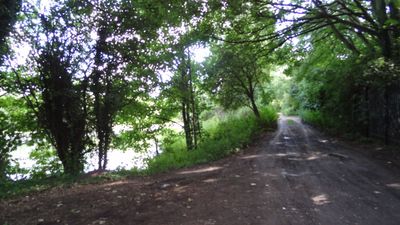
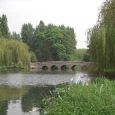
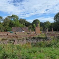
Ruxley Gravel Pits is a nature conservation site comprising several water-filled pits in the London Borough of Bromley. The River Cray flows through some of the lakes while natural springs feed others.

The site functioned as a gravel extraction facility between 1929 and 1951 before natural regeneration transformed it into an ecosystem. Official protection arrived in 1975 to safeguard this developing habitat.

The location serves as a research center for scientists studying 500 plant species, 169 bird varieties, and numerous insect populations in their natural environment.

Access to this site is limited and governed by conditions for specific activities. Visitors should check in advance which areas are open and what rules apply for use.

Rare plant species flourish in the lakes and along their edges, creating specialized habitats for adapted insects. The water surfaces display seasonal changes in their plant life that draw different kinds of wildlife.

The community of curious travelers

AroundUs brings together thousands of curated places, local tips, and hidden gems, enriched daily by 60,000 contributors worldwide.

Start exploring
GPS coordinates
51.41000,0.11700
Latest update
December 14, 2025 13:05
Around this place
Foots Cray Meadows
United Kingdom

Foots Cray Meadows

1.9 km
Frognal House
United Kingdom

Frognal House

1.2 km
St Botolph's Church, Ruxley
United Kingdom

St Botolph's Church, Ruxley

1.2 km
The Bull
United Kingdom

The Bull

756 m
Parish Church of St John the Evangelist
United Kingdom

Parish Church of St John the Evangelist

1.8 km
Church of St Mary
United Kingdom

Church of St Mary

1.7 km
Church of St Paulinus
United Kingdom

Church of St Paulinus

925 m
Parish Church of All Saints
United Kingdom

Parish Church of All Saints

1.3 km
Manor House
United Kingdom

Manor House

1.9 km
St Mary Cray War Memorial
United Kingdom

St Mary Cray War Memorial

1.7 km
Sidcup War Memorial
United Kingdom

Sidcup War Memorial

1.9 km
The Seven Stars Public House
United Kingdom

The Seven Stars Public House

917 m
Sheffield Monument (In Churchyard Of Parish Church Of St John The Evangelist)
United Kingdom

Sheffield Monument (In Churchyard Of Parish Church Of St John The Evangelist)

1.7 km
Stable Block To Former Foots Cray Place
United Kingdom

Stable Block To Former Foots Cray Place

1.7 km
The Blue Anchor Public House
United Kingdom

The Blue Anchor Public House

1.6 km
Cray Viaduct
United Kingdom

Cray Viaduct

1.7 km
Bowling Pavillion, Foots Cray Place
United Kingdom

Bowling Pavillion, Foots Cray Place

1.6 km
1-3, Chapmans Lane
United Kingdom

1-3, Chapmans Lane

816 m
Sidcup Place (Including Ha Ha To East)
United Kingdom

Sidcup Place (Including Ha Ha To East)

1.7 km
Walls Surrounding And To West And South West Of Parish Church Of St James And Gatepiers And Gates To West Of Church
United Kingdom

Walls Surrounding And To West And South West Of Parish Church Of St James And Gatepiers And Gates To West Of Church

2 km
Ruxley Farmhouse
United Kingdom

Ruxley Farmhouse

1.1 km
K6 Telephone Kiosk Junction Of Sandy Lane
United Kingdom

K6 Telephone Kiosk Junction Of Sandy Lane

766 m
Lime Tree House
United Kingdom

Lime Tree House

1.6 km
Tomb Of Frances Madocks To South Side Of Parish Church Of St James
United Kingdom

Tomb Of Frances Madocks To South Side Of Parish Church Of St James

2 km
87, High Street
United Kingdom

87, High Street

1.9 km
5-9, High Street
United Kingdom

5-9, High Street

1.6 km
Scadbury Manor moated site and fishponds
United Kingdom

Scadbury Manor moated site and fishponds

1.4 km
Milepost, Maidstone Road, Ruxley, E of Glebe Cottages, W of entrance to Manor Farm
United Kingdom

Milepost, Maidstone Road, Ruxley, E of Glebe Cottages, W of entrance to Manor Farm

1.3 km
Show the full map
Reviews
Share your experience

No review yet

Discussions
Start a discussion...

No discussion yet

« Ruxley Gravel Pits - Nature conservation area in London Borough of Bromley, England » is provided by Around Us (aroundus.com). Images and texts are derived from Wikimedia project under a Creative Commons license. You are allowed to copy, distribute, and modify copies of this page, under the conditions set by the license, as long as this note is clearly visible.

Discover hidden gems everywhere you go!

From secret cafés to breathtaking viewpoints, skip the crowded tourist spots and find places that match your style. Our app makes it easy with voice search, smart filtering, route optimization, and insider tips from travelers worldwide. Download now for the complete mobile experience.

Around Us App Screenshot

A unique approach to discovering new places

Le Figaro

All the places worth exploring

France Info

A tailor-made excursion in just a few clicks

20 Minutes

Around Us
Travel Guide & Maps
Download

Send to your phone

QR Code
1

Open the camera app on your mobile.

2

Point at the QR code with your camera. A notification will appear.

3

Tap the notification to open the link.