Sheriff Hutton Castle
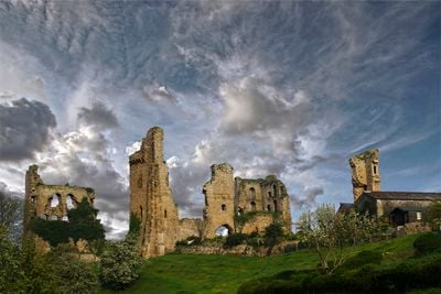
Sheriff Hutton Castle, Medieval quadrangular castle in Sheriff Hutton, England
Sheriff Hutton Castle is a rectangular fortified residence in Yorkshire with four stone towers marking its corners and walls that rise substantially above the ground. The layout follows a clear geometric design with corner bastions and defensive features characteristic of late medieval castle construction.
John Lewyn designed and built the fortress in 1382 for John Neville, incorporating advanced defensive techniques of the era. The structure with its four corner towers represented a new style of fortified residence that influenced later buildings across northern England.
The castle served as a school for children of noble families when Richard of Gloucester established a royal household for young aristocrats in 1484. The education of future leaders within these walls made it one of the most important places for aristocratic training in northern England.
The ruins sit on private land and visitors need to ask permission before exploring the site. It is best to arrange access in advance to ensure you can see the remains properly.
The name Sheriff Hutton refers to the official who once governed this area on behalf of the crown, making the castle part of a larger administrative network. Few visitors realize this connection between the settlement name and the broader system of royal control that shaped medieval England.
Location: Sheriff Hutton
Inception: 1382
Architects: John Lewyn
GPS coordinates: 54.08810,-1.00519
Latest update: December 8, 2025 19:51
Sutton Park
7 km
The Yorkshire Arboretum
7.1 km
Atlas Fountain
7.4 km
St Martin's Church, Whenby
4.1 km
Church of All Saints
4.9 km
Church of St Helen and the Holy Cross
570 m
Church of St Mary
5.3 km
Church of St Peter
5.2 km
Church of St John
7.1 km
Church of St Nicholas
7 km
Church of All Saints
4.9 km
Church of St Leonard
3.9 km
Church of St John Evangelist
7.2 km
Church of All Hallows
7 km
Church of St Martin
5 km
Monument To The 7th Earl Of Carlisle
6.3 km
Church of St Mary
5.9 km
Milestone, N of Sutton on the Forest
6.9 km
Carrmire Gates Wall And End Turrets
6.4 km
The Pyramid And Surrounding Piers
7.4 km
The Stables
7.1 km
The Obelisk
6.9 km
Milepost Approximately 440M North Of Lobster House, Claxton
6.4 km
Victoria Gate And Railings And Pier To North
7.1 km
Walled Garden Walls To Walled Garden With Gates Including The Satyr Gate And Corner Piers
7.1 km
Milepost Approximately 300 Yards East Of Field House, Flaxton
6.1 km
Milepost Approximately 159 Metres North East Of The Junction With The C61 Road
6.1 km
Milepost In Front Of Laughton House
6.9 kmVisited this place? Tap the stars to rate it and share your experience / photos with the community! Try now! You can cancel it anytime.
Discover hidden gems everywhere you go!
From secret cafés to breathtaking viewpoints, skip the crowded tourist spots and find places that match your style. Our app makes it easy with voice search, smart filtering, route optimization, and insider tips from travelers worldwide. Download now for the complete mobile experience.
A unique approach to discovering new places❞
— Le Figaro
All the places worth exploring❞
— France Info
A tailor-made excursion in just a few clicks❞
— 20 Minutes