St Christopher's Church, Pott Shrigley

Log in to your account

AroundUs is a community-driven map of interesting places, built by curious explorers like you. It grows with every review, story, and photo you share.
Connect to save your favorite spots, contribute locations, and create personalized routes.
Continue with Google
Continue with Apple
Continue with X
Continue with Facebook
Continue with email
By continuing, you accept our Terms and Conditions and our Privacy Policy
Create an account

St Christopher's Church, Pott Shrigley

Add to collection
Map
Suggest a change
Share

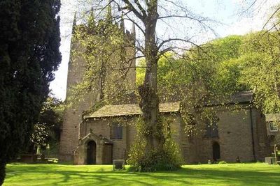
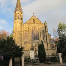
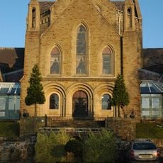
St Christopher's Church, Pott Shrigley, Medieval parish church in Pott Shrigley, England

St Christopher's Church is a medieval parish church in Pott Shrigley featuring a stone-slate roof, a west tower with battlements and pinnacles, and a nave with two wide aisles alongside a chancel. The building underwent substantial alteration with the addition of the Downes chantry chapel.

The church originated in the late 14th century as a chapel of ease for Prestbury parish and later developed into an independent place of worship. Key modifications over the centuries included the construction of the Downes chantry chapel, which shaped its present form.

The building contains relocated box pews from St James' Church in Gawsworth and memorials to the Downes and Lowther families created by prominent sculptors including John Bacon. These monuments reflect the artistic skill and social standing of families who shaped the interior over centuries.

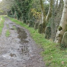
The church maintains regular Anglican services and welcomes visitors during operating hours on most days of the week. The churchyard and exterior can be freely explored, though the interior is best visited when services are not in progress.

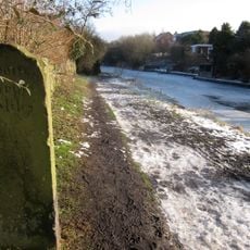
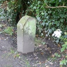
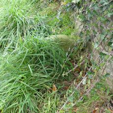
The churchyard contains a medieval preaching cross built from two large square stone blocks, with additional components added during the late Georgian period. This cross represents a rare surviving example of a platform where outdoor sermons were once delivered.

Location: Pott Shrigley

Inception: 15 century

Architectural style: English Gothic architecture

Website: http://pottshrigleychurch.org.uk

GPS coordinates: 53.30980,-2.08470

Latest update: December 14, 2025 13:01

Photos
Around this place
White Nancy
United Kingdom

White Nancy

2.2 km
Shrigley Hall
United Kingdom

Shrigley Hall

631 m
Clarence Mill
United Kingdom

Clarence Mill

1.5 km
St John the Baptist's Church, Bollington
United Kingdom

St John the Baptist's Church, Bollington

1.5 km
Bollington Methodist Church
United Kingdom

Bollington Methodist Church

1.9 km
Canal bridge number 22, 200 metres north west of Clark Green Farmhouse
United Kingdom

Canal bridge number 22, 200 metres north west of Clark Green Farmhouse

1.7 km
Canal Bridge Number 19
United Kingdom

Canal Bridge Number 19

2 km
Canal bridge number 23, 250 metres west of Winterford Farm
United Kingdom

Canal bridge number 23, 250 metres west of Winterford Farm

1.7 km
Hollin Hall Hotel
United Kingdom

Hollin Hall Hotel

2.2 km
Canal Bridge Number 27
United Kingdom

Canal Bridge Number 27

1.8 km
Canal Bridge Number 21
United Kingdom

Canal Bridge Number 21

1.8 km
Canal Bridge Number 25
United Kingdom

Canal Bridge Number 25

1.7 km
Canal Bridge Number 20
United Kingdom

Canal Bridge Number 20

1.7 km
Canal Bridge Number 26
United Kingdom

Canal Bridge Number 26

1.6 km
Chimney At Sj9378 7810
United Kingdom

Chimney At Sj9378 7810

1.3 km
Canal aqueduct over Palmerston Street
United Kingdom

Canal aqueduct over Palmerston Street

1.7 km
College of Missionary Chapel
United Kingdom

College of Missionary Chapel

580 m
Higher Doles Farmhouse
United Kingdom

Higher Doles Farmhouse

1.9 km
Macclesfield Canal: canal milestone at SJ 9305 7763
United Kingdom

Macclesfield Canal: canal milestone at SJ 9305 7763

2.1 km
Barn and shippon at Hedgerow Farm
United Kingdom

Barn and shippon at Hedgerow Farm

1.2 km
Macclesfield Canal distance marker at SJ 9325 7824
United Kingdom

Macclesfield Canal distance marker at SJ 9325 7824

1.5 km
Milestone on towpath south of canal bridge number 25
United Kingdom

Milestone on towpath south of canal bridge number 25

1.7 km
Weir At North End Of Clough Pool
United Kingdom

Weir At North End Of Clough Pool

2.2 km
Estate Boundary Stone At Sj 9401 7684
United Kingdom

Estate Boundary Stone At Sj 9401 7684

2.4 km
Brown House
United Kingdom

Brown House

1.9 km
Macclesfield Canal stone fence posts north of Bridge No.20
United Kingdom

Macclesfield Canal stone fence posts north of Bridge No.20

1.7 km
Distance stone on towpath 20 metres north of canal aqueduct
United Kingdom

Distance stone on towpath 20 metres north of canal aqueduct

1.7 km
Canal aqueduct over Grimshaw Lane
United Kingdom

Canal aqueduct over Grimshaw Lane

2.4 km
Show the full map
Reviews

Visited this place? Tap the stars to rate it and share your experience / photos with the community! Try now! You can cancel it anytime.

« St Christopher's Church, Pott Shrigley - Medieval parish church in Pott Shrigley, England » is provided by Around Us (aroundus.com). Images and texts are derived from Wikimedia project under a Creative Commons license. You are allowed to copy, distribute, and modify copies of this page, under the conditions set by the license, as long as this note is clearly visible.

Discover hidden gems everywhere you go!

From secret cafés to breathtaking viewpoints, skip the crowded tourist spots and find places that match your style. Our app makes it easy with voice search, smart filtering, route optimization, and insider tips from travelers worldwide. Download now for the complete mobile experience.

Around Us App Screenshot

A unique approach to discovering new places

Le Figaro

All the places worth exploring

France Info

A tailor-made excursion in just a few clicks

20 Minutes