Enable Location

We need your location to show you interesting places around you

Discover nearby places

Find interesting locations and hidden gems around you

Precise directions

Get accurate directions and distances to places

Your location is never shared with other users. It's only used when you tap the location button.

St Mary's Chapel, Lead

Log in to your account

Start exploring — it's free

Trusted by 61,473 travelers worldwide

Continue with Google
Continue with Apple
or

We will send you a code to connect

By continuing, you accept our Terms and Conditions and our Privacy Policy

Check your inbox

We've sent a pincode in your inbox. Please enter the code below.

St Mary's Chapel, Lead

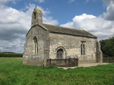
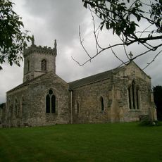
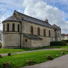
St Mary's Chapel, Lead, Medieval church in Lead, England

Description

St Mary's Chapel is a medieval stone building with a rectangular form and diagonal buttresses supporting its walls. A bell turret rises from the west gable, and the windows are divided into two sections with decorative trefoil designs typical of the period.

History

The chapel was founded on January 17, 1301, and was built near the location of the 1461 Battle of Towton. This battle became a pivotal moment during the Wars of the Roses fought in the Yorkshire region.

Culture

The floor slabs inside carry medieval inscriptions honoring the Tyas family members who commissioned this chapel for their manor house. Their names remain carved in stone, creating a connection between the building and its original patrons.

Practical

The building sits away from main roads and requires a walk through countryside to reach. Bringing a map or using navigation tools helps with finding it among the rural surroundings.

Did you know?

During the 1930s, local walkers rescued the chapel from decay and gave it the nickname Ramblers' Church. This volunteer effort became part of how the building is remembered today.

Location
Inception
14 century
GPS coordinates
53.82630,-1.29630
Latest update
December 11, 2025 18:11

AroundUs brings together thousands of curated places, local tips, and hidden gems, enriched daily by 60,000 contributors worldwide. Discover all places nearby (Lead).

Around this place
Hazlewood Castle
United Kingdom

Hazlewood Castle

3.3 km
Lotherton Hall
United Kingdom

Lotherton Hall

1.7 km
Nellie's Tree
United Kingdom

Nellie's Tree

4.1 km
Towton Hall
United Kingdom

Towton Hall

3.3 km
Parish Church of St Ricarius Or St Riquier
United Kingdom

Parish Church of St Ricarius Or St Riquier

3.1 km
Church of All Saints
United Kingdom

Church of All Saints

4.1 km
Church of All Saints
United Kingdom

Church of All Saints

1.2 km
Lotherton Chapel
United Kingdom

Lotherton Chapel

1.7 km
Milepost Against Wall Of Garden To St Wilfrids Roman Catholic Church
United Kingdom

Milepost Against Wall Of Garden To St Wilfrids Roman Catholic Church

3.1 km
Huddleston Hall
United Kingdom

Huddleston Hall

2.9 km
The Swan Hotel
United Kingdom

The Swan Hotel

3.1 km
Aberford Bridge
United Kingdom

Aberford Bridge

3.1 km
Gascoigne Almshouses And Attached Wardens Cottage
United Kingdom

Gascoigne Almshouses And Attached Wardens Cottage

3.2 km
Milestone Approximately 70 Metres South Of Junction With Back Lane
United Kingdom

Milestone Approximately 70 Metres South Of Junction With Back Lane

3.2 km
Dacre's Cross
United Kingdom

Dacre's Cross

2.2 km
The Church of the Immaculate Conception St John the Worker
United Kingdom

The Church of the Immaculate Conception St John the Worker

2.8 km
Shelter At Approximately Se428368
United Kingdom

Shelter At Approximately Se428368

3.8 km
Market Cross Beside South Gate To Church Of St Ricarius
United Kingdom

Market Cross Beside South Gate To Church Of St Ricarius

3.1 km
Lodge To Gascoigne Almshouses
United Kingdom

Lodge To Gascoigne Almshouses

3.2 km
Milestone Approximately 100 Metres North Of Junction With Scarthingwell Lane
United Kingdom

Milestone Approximately 100 Metres North Of Junction With Scarthingwell Lane

2.5 km
Milestone Approximately 20 Metres North Of Junction With Old London Road
United Kingdom

Milestone Approximately 20 Metres North Of Junction With Old London Road

3.6 km
Pikes Head Lodge
United Kingdom

Pikes Head Lodge

3.4 km
Milestone Approimately 50 Metres South Of Junction With Scarthingwell Lane
United Kingdom

Milestone Approimately 50 Metres South Of Junction With Scarthingwell Lane

2.4 km
Aberford House Including Front Garden Wall With Gatepiers And Inner Paved Parterre With Steps
United Kingdom

Aberford House Including Front Garden Wall With Gatepiers And Inner Paved Parterre With Steps

3.1 km
The Dark Arch
United Kingdom

The Dark Arch

4.2 km
Mile Post At Se433381
United Kingdom

Mile Post At Se433381

3.3 km
Aberford War Memorial
United Kingdom

Aberford War Memorial

3.1 km
Milestone, Great North Road, Old Micklefield
United Kingdom

Milestone, Great North Road, Old Micklefield

4 km
Show the full map
« St Mary's Chapel, Lead - Medieval church in Lead, England » is provided by Around Us (aroundus.com). Images and texts are derived from Wikimedia project under a Creative Commons license. You are allowed to copy, distribute, and modify copies of this page, under the conditions set by the license, as long as this note is clearly visible.

Discover hidden gems everywhere you go!

From secret cafés to breathtaking viewpoints, skip the crowded tourist spots and find places that match your style. Our app makes it easy with voice search, smart filtering, route optimization, and insider tips from travelers worldwide. Download now for the complete mobile experience.

Around Us App Screenshot

A unique approach to discovering new places

Le Figaro

All the places worth exploring

France Info

A tailor-made excursion in just a few clicks

20 Minutes

Around Us
Travel Guide & Maps
Download

Send to your phone

QR Code
1

Open the camera app on your mobile.

2

Point at the QR code with your camera. A notification will appear.

3

Tap the notification to open the link.