St Giles' Church, Imber

Log in to your account

AroundUs is a community-driven map of interesting places, built by curious explorers like you. It grows with every review, story, and photo you share.
Connect to save your favorite spots, contribute locations, and create personalized routes.
By continuing, you accept our Terms and Conditions and our Privacy Policy
Add to collection
Map
Suggest a change
Share

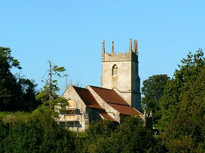
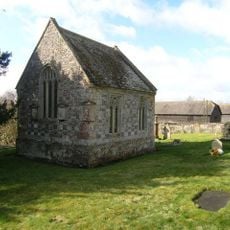
St Giles' Church, Imber, Medieval church in Imber, England

St Giles' Church in Imber is a limestone church with a square tower topped by five pinnacles and aisles extending along both sides. Large windows with stone tracery patterns punctuate the walls, allowing light into the interior spaces.

This church originated in the late 13th century as a parish center. In 1943, the entire community was evacuated so the area could be used for military training operations.

Interior wall paintings from the 15th century depict moral scenes such as the Weighing of Souls, serving as visual lessons for the community. These religious images helped convey spiritual teachings to people who could not read.

Access requires special permission in advance, and visits are limited to specific days during spring, summer, and winter due to the site's location within a military training zone. Plan ahead and check availability before traveling.

The tower contains hand-painted numerical patterns from 1692 marked on its interior walls. These markings represent some of the earliest documented records of bell-ringing sequences ever created.

Location: Heytesbury

Inception: 13 century

Website: https://imberchurch.org.uk

GPS coordinates: 51.23440,-2.05111

Latest update: December 12, 2025 09:03

Photos
Around this place
Knook Castle
United Kingdom

Knook Castle

4.4 km
Church of All Saints
United Kingdom

Church of All Saints

5.1 km
Milestone, Breach Hill; 230m S jcn Chitterne-Tilshead rd 7m E current track
United Kingdom

Milestone, Breach Hill; 230m S jcn Chitterne-Tilshead rd 7m E current track

5 km
Chapel Of St Mary
United Kingdom

Chapel Of St Mary

5.1 km
Two Monuments In Railed Enclosure, In The Churchyard, About 17 Metres South West Of The Tower Of Church Of St Giles
United Kingdom

Two Monuments In Railed Enclosure, In The Churchyard, About 17 Metres South West Of The Tower Of Church Of St Giles

56 m
Pear Tree House
United Kingdom

Pear Tree House

5.2 km
White Hart House
United Kingdom

White Hart House

5.2 km
The Manor
United Kingdom

The Manor

5 km
Clump House
United Kingdom

Clump House

5.2 km
The Round House
United Kingdom

The Round House

5 km
Ingram, Wallis And Parham Monuments In The Churchyard About 16 Metres South West Of Chapel Of St Mary
United Kingdom

Ingram, Wallis And Parham Monuments In The Churchyard About 16 Metres South West Of Chapel Of St Mary

5.1 km
The Glebe House
United Kingdom

The Glebe House

5.1 km
Milestone About 200 Metres North Along Green Lane To West Of St Mary's House
United Kingdom

Milestone About 200 Metres North Along Green Lane To West Of St Mary's House

4.8 km
The Old Malthouse
United Kingdom

The Old Malthouse

5.2 km
The Coach House
United Kingdom

The Coach House

5 km
Manor Farm House
United Kingdom

Manor Farm House

4.8 km
The Robbers' Stone
United Kingdom

The Robbers' Stone

5.2 km
Elm Farm
United Kingdom

Elm Farm

5.2 km
Stable To South Of The Manor
United Kingdom

Stable To South Of The Manor

5.1 km
The King's Head
United Kingdom

The King's Head

5.1 km
98, Chitterne Road
United Kingdom

98, Chitterne Road

5.2 km
Milestone By Junction Of Footpath From Great Cheverell And Lane To Coulston
United Kingdom

Milestone By Junction Of Footpath From Great Cheverell And Lane To Coulston

4 km
Gateway At The Gatehouse
United Kingdom

Gateway At The Gatehouse

4.9 km
Chitterne House
United Kingdom

Chitterne House

4.9 km
Milestone About 1 Mile South West Of Chitterne
United Kingdom

Milestone About 1 Mile South West Of Chitterne

5.2 km
Chitterne Lodge
United Kingdom

Chitterne Lodge

4.9 km
Robber's Stone
United Kingdom

Robber's Stone

4.5 km
Bowl barrow: one of a dispersed group of five barrows adjacent to the Imber-Warminster track
United Kingdom

Bowl barrow: one of a dispersed group of five barrows adjacent to the Imber-Warminster track

2.4 km
Show the full map
Reviews

Visited this place? Tap the stars to rate it and share your experience / photos with the community! Try now! You can cancel it anytime.

« St Giles' Church, Imber - Medieval church in Imber, England » is provided by Around Us (aroundus.com). Images and texts are derived from Wikimedia project under a Creative Commons license. You are allowed to copy, distribute, and modify copies of this page, under the conditions set by the license, as long as this note is clearly visible.

Discover hidden gems everywhere you go!

From secret cafés to breathtaking viewpoints, skip the crowded tourist spots and find places that match your style. Our app makes it easy with voice search, smart filtering, route optimization, and insider tips from travelers worldwide. Download now for the complete mobile experience.

Around Us App Screenshot

A unique approach to discovering new places

Le Figaro

All the places worth exploring

France Info

A tailor-made excursion in just a few clicks

20 Minutes