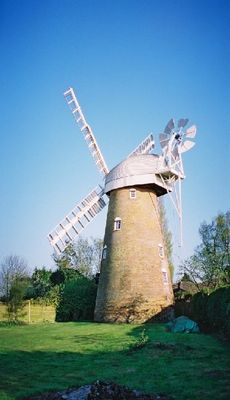
Stock Windmill, Tower windmill in Stock, United Kingdom
Stock Windmill is a five-story brick tower structure that stands about 52 feet tall and demonstrates traditional English mill construction methods. The building features four patent sails and a rotating six-bladed tail, which automatically adjusts the entire structure to face the wind.
The mill was built in the 1800s as a working grain-milling operation for the local community. After Essex County Council acquired it in 1945, significant restoration took place decades later to protect the historic structure.
For centuries, this mill served as a vital meeting point where local farmers brought their grain for processing. The structure itself shows how central such places were to community life and trade.
The building opens on select days during warmer months, so visitors should plan ahead and arrive early since visiting slots are limited. A typical visit takes one to two hours, and sturdy shoes are advisable because climbing multiple flights of stairs is required.
During its operating years, the mill was equipped with steam and internal combustion engines, meaning grain processing could continue even without wind. This practical setup shows how millers modernized their work to operate regardless of weather conditions.
Location: Stock
GPS coordinates: 51.66200,0.45600
Latest update: December 14, 2025 11:00
Ingatestone Hall
4.5 km
Norsey Wood
3.6 km
Lake Meadows
4.1 km
Church of St Mary
3.6 km
Crowsheath Wood
3.6 km
Milestone And Cover Plate 45 Metres South West Of Ivy Cottage
4.4 km
Church of All Saints
1.2 km
Church of St Margaret
3.8 km
Church of St Michael and All Angels
4.2 km
Church of St Peter
4.5 km
Church of St Mary and St Edward
3.7 km
The Cock Inn
976 m
The Red Lion Inn
4.4 km
The Spread Eagle Inn
4.1 km
Ingatestone Hall Gatehouse
4.5 km
The Three Compasses Public House
2.8 km
Stock and Buttsbury War Memorial
817 m
Whites Bridge
3.5 km
Milestone 27 Metres South South West Of The Spread Eagle Public House
4.1 km
Milestone 12 Metres North West Of 9 Maldon Road
3.9 km
Milestone 80 Metres East Of Whites Bridge
3.4 km
Gascoignes Farmhouse
2.8 km
Milestone, Maldon Road, by gate to public footpath
3.9 km
Milestone, opp. Spread Eagle PH
4.1 km
Milestone, 100m NE of Church Hall Road
4.4 km
Milestone, 30m E of Whites Bridge
3.5 km
Milestone, Margaretting Road, 100m E of car park entrance for Galleywood Common
4 km
Hanningfield Reservoir
3.4 kmVisited this place? Tap the stars to rate it and share your experience / photos with the community! Try now! You can cancel it anytime.
Discover hidden gems everywhere you go!
From secret cafés to breathtaking viewpoints, skip the crowded tourist spots and find places that match your style. Our app makes it easy with voice search, smart filtering, route optimization, and insider tips from travelers worldwide. Download now for the complete mobile experience.
A unique approach to discovering new places❞
— Le Figaro
All the places worth exploring❞
— France Info
A tailor-made excursion in just a few clicks❞
— 20 Minutes