Twmbarlwm, Iron Age hillfort and Norman castle site in Risca, Great Britain
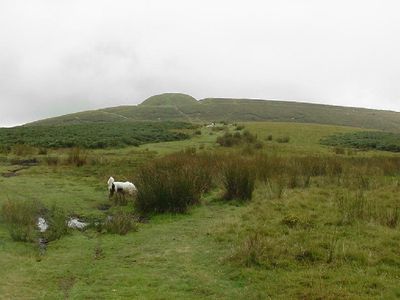
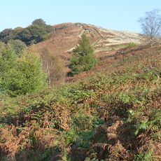
Twmbarlwm is a hilltop site with fortification remains on its peak that rises 419 meters above the surrounding landscape. The distinctive mound, known locally as the Twmp, shows traces of occupation and defenses from two separate periods in history.
The site was first built as a fort by the Silures tribe during the Iron Age, then later transformed by Norman settlers. This shift from a tribal stronghold to a medieval fortress shows how the purpose of this hilltop changed over the centuries.
The summit draws visitors who come for its connection to long-standing walking traditions in the area. Annual Good Friday walks show how this place remains active in the local community's identity.
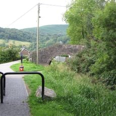
Several walking paths lead up from the car park below to the summit, with the shortest route taking about half a mile through hillside trails. The paths are clearly marked and offer different options for various levels of fitness and experience.
The hill is connected in local stories to treasure and mysterious bee swarms that supposedly guard the summit according to old tales. These folk legends give the place a legendary reputation that remains known among older residents today.
Location: Risca
Elevation above the sea: 419 m
GPS coordinates: 51.62767,-3.09374
Latest update: December 8, 2025 19:41
Mynydd Machen
3.3 km
St Mary and St Mercurius Coptic Orthodox Church
1.8 km
Mynydd y Lan
3.6 km
English Baptist Church
3 km
Church of St Luke
3.7 km
Hafod quarry
4.3 km
Risca Library
2.4 km
Church of St Mary Risca
1.7 km
Morbitorium
2.3 km
Church Of Saint Peter
2.9 km
Bethany English Baptist Church and attached Sunday School
2.4 km
Moriah Baptist Church
2.2 km
Abercarn Library
3.5 km
Former Risca Collieries Workmen's Institute
1.9 km
Palace Cinema
2.4 km
Canal Bridge over Monmouthshire and Brecon Canal by Moriah Hill
2.1 km
Jubilee Statue in Tredegar Grounds
2.3 km
Canal Bridge over Monmouthshire and Brecon Canal E of Pen y van
3.2 km
Canal Bridge over Monmouthshire and Brecon Canal W of Penrhiw
1.7 km
Canal Bridge over Monmouthshire and Brecon Canal N of Little Oak
4.3 km
Pontywaun Viaduct
2.6 km
Canal Bridge over Monmouthshire and Brecon Canal at Darren Road
1.5 km
Abercarn War Memorial
3.6 km
Canal Bridge over Monmouthshire and Brecon Canal S of Ty Sign
2.8 km
Entrance Gateway at Churchyard of St Mary Risca
1.7 km
Former Penllwyn Tramroad Viaduct at Nine Mile Point
4.3 km
Canal Bridge over Monmouthshire and Brecon Canal E of Cwmbyr
1.5 km
Pentre-bach And Attached Outbuildings
4.2 kmVisited this place? Tap the stars to rate it and share your experience / photos with the community! Try now! You can cancel it anytime.
Discover hidden gems everywhere you go!
From secret cafés to breathtaking viewpoints, skip the crowded tourist spots and find places that match your style. Our app makes it easy with voice search, smart filtering, route optimization, and insider tips from travelers worldwide. Download now for the complete mobile experience.
A unique approach to discovering new places❞
— Le Figaro
All the places worth exploring❞
— France Info
A tailor-made excursion in just a few clicks❞
— 20 Minutes