Enable Location

We need your location to show you interesting places around you

Discover nearby places

Find interesting locations and hidden gems around you

Precise directions

Get accurate directions and distances to places

Your location is never shared with other users. It's only used when you tap the location button.

The Bridestones

Log in to your account

Start exploring — it's free

Trusted by 66,907 travelers worldwide

Continue with Google
Continue with Apple
or

We will send you a code to connect

By continuing, you accept our Terms and Conditions and our Privacy Policy

Check your inbox

We've sent a pincode in your inbox. Please enter the code below.

Discussion Reviews 1 Photos
4.3k Popularity

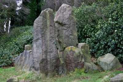
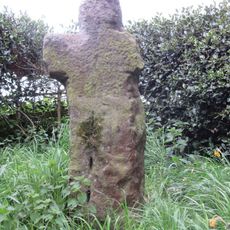
The Bridestones, Neolithic burial site in Congleton, England.

The Bridestones is a Neolithic burial site near Congleton, made up of a stone chamber built from large, flat slabs set upright. The chamber once had a central dividing wall, parts of which are still visible, giving a sense of how the interior was divided.

The site was built during the Neolithic period, somewhere between 3500 and 2400 BCE, and was used as a burial place for more than one person. Excavations carried out in the 1930s found traces of ancient cremations on the spot.

The name may come from Brigantia, a Celtic goddess, or from Old English words describing the shape of the stones. Visitors can see how the stones were deliberately placed to remain visible across the open land around them.

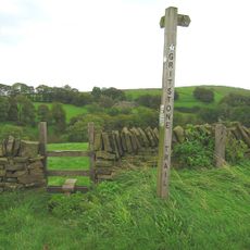
The monument sits on the western slope of Bosley Cloud hill and is open all year with no admission required. Because it stands on an open hillside, sturdy footwear and weatherproof clothing make the visit more comfortable.

The original structure once covered a much larger area and was surrounded by a stone circle with four portal stones at its entrance. Today only two of those portal stones remain standing, and most of the wider layout has disappeared over time.

The community of curious travelers

AroundUs brings together thousands of curated places, local tips, and hidden gems, enriched daily by 60,000 contributors worldwide.

Start exploring
Location
GPS coordinates
53.15669,-2.14161
Latest update
March 3, 2026 08:11
Around this place
Cheshire Gritstone Trail
United Kingdom

Cheshire Gritstone Trail

1.1 km
Church of St Lawrence, Rushton Spencer
United Kingdom

Church of St Lawrence, Rushton Spencer

2.8 km
Congleton Viaduct
United Kingdom

Congleton Viaduct

3 km
Macclesfield Canal Bridge Number 58 at SJ 9024 6514
United Kingdom

Macclesfield Canal Bridge Number 58 at SJ 9024 6514

3 km
Cross, Approximately 7 Metres South Of Nave Of Church Of St Lawrence
United Kingdom

Cross, Approximately 7 Metres South Of Nave Of Church Of St Lawrence

2.8 km
Hargreaves Memorial And Railed Enclosure Approximately 15 Metres South Of Church Of St Lawrence
United Kingdom

Hargreaves Memorial And Railed Enclosure Approximately 15 Metres South Of Church Of St Lawrence

2.8 km
Bridge
United Kingdom

Bridge

3 km
Hug Bridge
United Kingdom

Hug Bridge

2.8 km
Dane Aqueduct
United Kingdom

Dane Aqueduct

3.1 km
The Knot Inn
United Kingdom

The Knot Inn

3 km
Lymford Bridge
United Kingdom

Lymford Bridge

3 km
Macclesfield Canal Bridge Number 57 at SJ 9051 6518
United Kingdom

Macclesfield Canal Bridge Number 57 at SJ 9051 6518

3 km
Macclesfield Canal Bridge Number 60 at SJ 8927 6506
United Kingdom

Macclesfield Canal Bridge Number 60 at SJ 8927 6506

3.2 km
Cloud House Farm
United Kingdom

Cloud House Farm

1.9 km
Bridge No. 70
United Kingdom

Bridge No. 70

2.9 km
Canal milestone at SJ 8775 6378
United Kingdom

Canal milestone at SJ 8775 6378

3.3 km
Biddulph Old Hall
United Kingdom

Biddulph Old Hall

2.4 km
Bridge No. 72
United Kingdom

Bridge No. 72

2.6 km
Bridge No. 69
United Kingdom

Bridge No. 69

3.2 km
Milestone Nw Of Overton End Farm
United Kingdom

Milestone Nw Of Overton End Farm

1.2 km
Ringwork castle in Bailey's Wood
United Kingdom

Ringwork castle in Bailey's Wood

3.2 km
Macclesfield Canal aqueduct over Biddulph Valley Way
United Kingdom

Macclesfield Canal aqueduct over Biddulph Valley Way

2.6 km
Macclesfield Canal Milestone At Sj 8965 6517
United Kingdom

Macclesfield Canal Milestone At Sj 8965 6517

3.1 km
Macclesfield Canal Stone Fence Posts South Of Bridge No. 72
United Kingdom

Macclesfield Canal Stone Fence Posts South Of Bridge No. 72

2.7 km
Milestone Outside No 279
United Kingdom

Milestone Outside No 279

3.1 km
Macclesfield Canal Canal Milestone At Sj 8782 6233
United Kingdom

Macclesfield Canal Canal Milestone At Sj 8782 6233

2.8 km
Shepherd's Cross
United Kingdom

Shepherd's Cross

2 km
Milestone, Lee House, N of Biddulph
United Kingdom

Milestone, Lee House, N of Biddulph

3.1 km
Show the full map
Reviews
Share your experience

No review yet

Discussions
Start a discussion...

No discussion yet

« The Bridestones - Neolithic burial site in Congleton, England » is provided by Around Us (aroundus.com). Images and texts are derived from Wikimedia project under a Creative Commons license. You are allowed to copy, distribute, and modify copies of this page, under the conditions set by the license, as long as this note is clearly visible.

Discover hidden gems everywhere you go!

From secret cafés to breathtaking viewpoints, skip the crowded tourist spots and find places that match your style. Our app makes it easy with voice search, smart filtering, route optimization, and insider tips from travelers worldwide. Download now for the complete mobile experience.

Around Us App Screenshot

A unique approach to discovering new places

Le Figaro

All the places worth exploring

France Info

A tailor-made excursion in just a few clicks

20 Minutes

Around Us
Travel Guide & Maps
Download

Send to your phone

QR Code
1

Open the camera app on your mobile.

2

Point at the QR code with your camera. A notification will appear.

3

Tap the notification to open the link.