Chest opened
+${chestReward.xp} XP
Explorer
NOUVEAU ×${chestReward.collectible.quantity}
tapez pour fermer
Chest locked

Open chests in the app

Around Us is built for your phone — chests unlock when you walk, explore and capture nearby places.

Enable Location

We need your location to show you interesting places around you

Discover nearby places

Find interesting locations and hidden gems around you

Precise directions

Get accurate directions and distances to places

Your location is never shared with other users. It's only used when you tap the location button.

Thorpe Cloud

Log in to your account

Start exploring — it's free

Trusted by 72,887 travelers worldwide

Continue with Google
Continue with Apple
or

We will send you a code to connect

By continuing, you accept our Terms and Conditions and our Privacy Policy

Check your inbox

We've sent a pincode in your inbox. Please enter the code below.

Thorpe Cloud
Discussion Reviews 1 Photos
11.5k Popularity

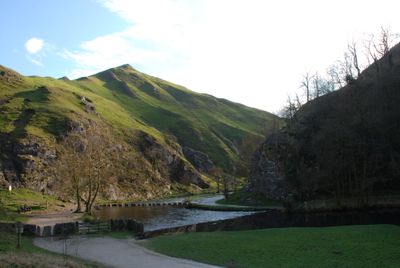
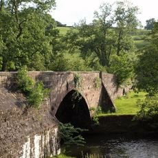
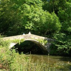
Thorpe Cloud, Limestone hill in Derbyshire, England

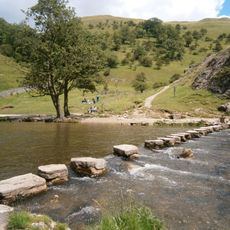
Thorpe Cloud is a limestone hill that rises to 287 meters between the villages of Thorpe and Ilam, forming a distinct peak at the southern entrance of Dovedale. The formation displays visible rock layers and steep slopes that make it a recognizable landmark visible from many directions across the valley floor.

The hill became part of the National Trust's South Peak Estate through a major land acquisition in 1934, ensuring its protection as a public walking destination. This action made the natural landscape accessible for visitors to explore and appreciate for generations to come.

Photographers and outdoor enthusiasts gather at Thorpe Cloud throughout the year to document their climbs and record the changing seasonal landscapes.

Several walking paths connect the base to the summit, accessible from parking areas near the Dovedale region. The route is best tackled in dry conditions, as the paths can become slippery when wet.

During summer solstice periods, observers at the summit can witness a double sunset phenomenon under specific weather conditions.

The community of curious travelers

AroundUs brings together thousands of curated places, local tips, and hidden gems, enriched daily by 60,000 contributors worldwide.

Start exploring
Location
Elevation above the sea
287 m
GPS coordinates
53.05604,-1.77616
Latest update
December 8, 2025 13:40
Around this place
Ilam Park
United Kingdom

Ilam Park

2 km
Church of St Leonard
United Kingdom

Church of St Leonard

989 m
Church of the Holy Cross
United Kingdom

Church of the Holy Cross

1.9 km
Tower Aproximately 20 Yards North Of Ilam Hall
United Kingdom

Tower Aproximately 20 Yards North Of Ilam Hall

2 km
Coldwall Bridge
United Kingdom

Coldwall Bridge

1.3 km
Mrs Watts-Russell Memorial
United Kingdom

Mrs Watts-Russell Memorial

1.6 km
St Bertram's Bridge
United Kingdom

St Bertram's Bridge

1.9 km
Dovedale House
United Kingdom

Dovedale House

1.7 km
Milestone At Ngr 150 497
United Kingdom

Milestone At Ngr 150 497

1.2 km
Gate, Gate Piers And Adjoining Walls To Ilam Park
United Kingdom

Gate, Gate Piers And Adjoining Walls To Ilam Park

1.7 km
School House
United Kingdom

School House

1.7 km
Dovedale Stepping Stones
United Kingdom

Dovedale Stepping Stones

363 m
Coach House And Stable Block Approximately 20 Yards South West Of Ilam Hall
United Kingdom

Coach House And Stable Block Approximately 20 Yards South West Of Ilam Hall

2 km
Bridge over River Manifold
United Kingdom

Bridge over River Manifold

1.5 km
Anglo-Scandinavian cross, 7m south of the south transept of the Church of the Holy Cross
United Kingdom

Anglo-Scandinavian cross, 7m south of the south transept of the Church of the Holy Cross

1.9 km
Ilam Church Of England School
United Kingdom

Ilam Church Of England School

1.7 km
Anglo-Scandinavian cross, 12m south of the south porch of the Church of the Holy Cross
United Kingdom

Anglo-Scandinavian cross, 12m south of the south porch of the Church of the Holy Cross

1.9 km
St Marys Bridge
United Kingdom

St Marys Bridge

700 m
Thorpe House
United Kingdom

Thorpe House

683 m
St Marys Bridge
United Kingdom

St Marys Bridge

726 m
Green Croft  Green Gables  Green Lea
United Kingdom

Green Croft Green Gables Green Lea

830 m
Gatehouse Lodge
United Kingdom

Gatehouse Lodge

1.7 km
Sharp Low bowl barrow
United Kingdom

Sharp Low bowl barrow

2.1 km
The Old House
United Kingdom

The Old House

985 m
Church Lodge
United Kingdom

Church Lodge

1.8 km
Turret, Loggia, Steps And Parapet To Terrace Immediately South South East Of Ilam Hall
United Kingdom

Turret, Loggia, Steps And Parapet To Terrace Immediately South South East Of Ilam Hall

2 km
Home Farmhouse
United Kingdom

Home Farmhouse

1.6 km
Sundial in churchyard, 10  yards south of south porch
United Kingdom

Sundial in churchyard, 10 yards south of south porch

1 km
Show the full map
Reviews
Share your experience

No review yet

Discussions
Start a discussion...

No discussion yet

« Thorpe Cloud - Limestone hill in Derbyshire, England » is provided by Around Us (aroundus.com). Images and texts are derived from Wikimedia project under a Creative Commons license. You are allowed to copy, distribute, and modify copies of this page, under the conditions set by the license, as long as this note is clearly visible.

Discover hidden gems everywhere you go!

From secret cafés to breathtaking viewpoints, skip the crowded tourist spots and find places that match your style. Our app makes it easy with voice search, smart filtering, route optimization, and insider tips from travelers worldwide. Download now for the complete mobile experience.

Around Us App Screenshot

A unique approach to discovering new places

Le Figaro

All the places worth exploring

France Info

A tailor-made excursion in just a few clicks

20 Minutes

Around Us
Travel Guide & Maps
Download

Send to your phone

QR Code
1

Open the camera app on your mobile.

2

Point at the QR code with your camera. A notification will appear.

3

Tap the notification to open the link.