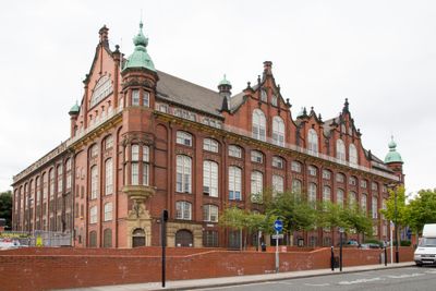
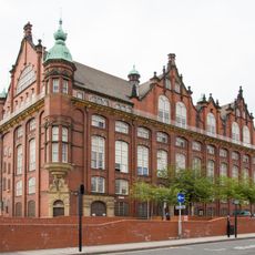
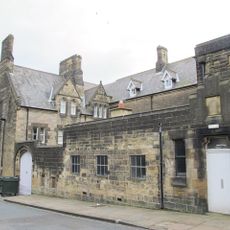
Tyne and Wear Archives Service, County record office in Newcastle upon Tyne, United Kingdom.
The Tyne and Wear Archives Service is a county record office in Newcastle upon Tyne that preserves documents dating back roughly 9 centuries and is housed on about 20 kilometers of shelving. The collection covers a wide range of materials related to the industrial and urban history of the region.
The archive was established in 1974 as an institution under Tyne and Wear County Council and brought together collections from the Newcastle Archives Office. Its current form took shape after a reorganisation in 1986 that made operations more efficient.
The archives hold extensive records of shipbuilding, engineering work, and industrial production that show the manufacturing heritage of the region. Visitors can see how these materials document the maritime and technical past of the area.
Visitors need to book in advance to access the search room, as it is not open to drop-in visitors at any time. Staff can assist with ordering document copies or research help if you contact them ahead of your visit.
The shipbuilding collection was added to the UNESCO Memory of the World Register, recognising the global importance of these documents. This makes it a place of international interest for anyone researching maritime history.
Location: Newcastle upon Tyne
Part of: Tyne & Wear Archives & Museums
Address: Blandford House, Blandford Square, Newcastle Upon Tyne, England, NE1 4JA
Website: https://twarchives.org.uk
GPS coordinates: 54.96900,-1.62500
Latest update: December 14, 2025 18:09
Turbinia
35 m
Discovery Museum
31 m
Centre for Life
329 m
St Mary's Cathedral, Newcastle upon Tyne
319 m
Hadrian's Tower
316 m
Tyne Theatre and Opera House
308 m
Former Co-operative Wholesale Society Printing Works
353 m
Blandford House
10 m
Alfred Wilson House
241 m
Grainger Memorial Fountain
243 m
Former Market Keeper's House
290 m
200 And 202, Westgate Road
257 m
1 Neville Street
341 m
Barclays Bank
292 m
26-36, Clayton Street West
317 m
11-33, Summerhill Street
330 m
The Coach House
115 m
190, Westgate Road
256 m
St Pauls Church Of England School (North Part)
278 m
Steps And Railings To Right Of Number 2
178 m
Railings And Walls To South And East Of Hospital Of St Mary The Virgin Almshouses
272 m
1-10, Winchester Terrace
303 m
St Anne's Convent And Walls Attached
214 m
236, Westgate Road
297 m
178, Westgate Road
261 m
260, Westgate Road
351 m
7-12, Summerhill Terrace
117 m
Hospital Of St Mary The Virgin Almshouses
312 mVisited this place? Tap the stars to rate it and share your experience / photos with the community! Try now! You can cancel it anytime.
Discover hidden gems everywhere you go!
From secret cafés to breathtaking viewpoints, skip the crowded tourist spots and find places that match your style. Our app makes it easy with voice search, smart filtering, route optimization, and insider tips from travelers worldwide. Download now for the complete mobile experience.
A unique approach to discovering new places❞
— Le Figaro
All the places worth exploring❞
— France Info
A tailor-made excursion in just a few clicks❞
— 20 Minutes