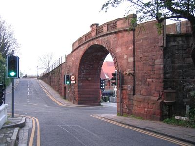
Watergate, Chester, Grade I listed arch bridge in Chester, England
Watergate is an arch bridge built with red sandstone that spans the A548 road in Chester's city center. Its structure features a basket arch with textured stonework and a parapet with stone railings on both sides.
The current structure was built between 1788 and 1790 by architect Joseph Turner, replacing a medieval gate that was damaged during the siege of Chester. Its construction marked a shift from defensive fortification to a functional crossing point.
This bridge is woven into Chester's city walls, showing how the town has kept its medieval defensive network alive and in use. Walking across it, you experience a connection that locals have relied on for centuries.
The footpath across the bridge connects Watergate Street to New Crane Street and links directly to Chester's city walls walk. The crossing is straightforward to navigate and clearly marked, making it easy to access this section of the historic circuit.
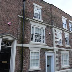
A Victorian drinking fountain from 1857 is fixed to the north abutment of the bridge, added decades after the structure was completed. This addition shows how the bridge adapted to serve new needs as the city changed.
Location: Cheshire West and Chester
Architects: Joseph Turner
Official opening: 1790
Made from material: stone
Part of: Chester city walls
GPS coordinates: 53.18940,-2.89740
Latest update: December 14, 2025 09:41
Stanley Palace
114 m
Guildhall, Chester
195 m
Bishop Lloyd's House
273 m
Chester Royal Infirmary
223 m
Old Custom House Inn, Chester
196 m
10–28 Nicholas Street, Chester
157 m
Watergate House, Chester
80 m
St Ursula's, Chester
286 m
Sedan House, Chester
67 m
Numbers 48 and 50 Street
263 m
Numbers 54 and 56 Street, Watergate Street and Row
251 m
Number 52 Street, Watergate Street and Row
256 m
Old Custom House Building, Chester
175 m
Numbers 58-66 Street
236 m
51 Watergate Street and 59 Watergate Row South
252 m
3, Stanley Street
128 m
5 And 7, St Martins Way
256 m
Number 39 Street/Numbers 47 and 49 Row
276 m
Numbers 44 and 46 Street
270 m
Numbers 34, 36 and 38 Row/Numbers 38, 40 and 42 Street
284 m
49 Watergate Street and 55-57 Watergate Row South
258 m
The Friars
262 m
43, White Friars
281 m
37 and 39, White Friars
304 m
41, White Friars
292 m
Part Of City Wall From The Watergate To Bonewaldesthorne Tower
194 m
Numbers 61 And 63 Street Numbers 71 And 77 Row
215 m
Part Of Roman Quay Wall South Of Lateral Steps From Nuns Road
294 mVisited this place? Tap the stars to rate it and share your experience / photos with the community! Try now! You can cancel it anytime.
Discover hidden gems everywhere you go!
From secret cafés to breathtaking viewpoints, skip the crowded tourist spots and find places that match your style. Our app makes it easy with voice search, smart filtering, route optimization, and insider tips from travelers worldwide. Download now for the complete mobile experience.
A unique approach to discovering new places❞
— Le Figaro
All the places worth exploring❞
— France Info
A tailor-made excursion in just a few clicks❞
— 20 Minutes