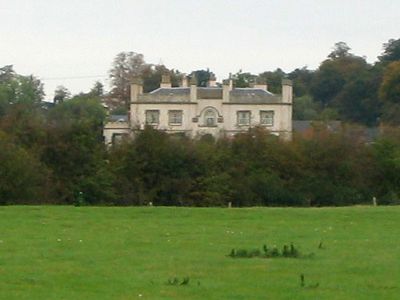
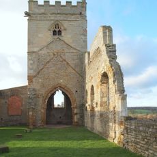
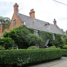
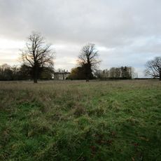
Wiverton Hall, Grade II* listed country house in Nottinghamshire, England
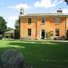
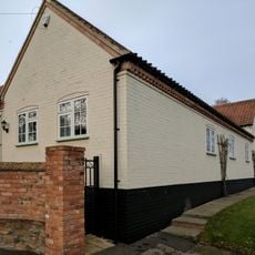
Wiverton Hall is a country house in Nottinghamshire that displays architectural features typical of the early 19th century. The building includes a notable service range positioned at the rear left, showing how estates organized domestic and working spaces separately.
A manor from 1450 created by Sir Thomas Chaworth was destroyed during the English Civil War. The current building was constructed in 1814 after the property passed to new ownership following the family's losses.
The property transferred ownership from the Chaworth family to the Musters through marriage in 1805, marking a significant change in the estate's lineage.
The house holds protected heritage status, which affects any alterations or maintenance work on the property. It is advisable to check access availability before visiting, as the grounds may have restricted hours.
During the English Civil War, the manor was fortified and hosted high-ranking royal visitors including a queen and prince. This military importance made it a focal point in the regional conflict.
Location: Wiverton Hall
GPS coordinates: 52.92010,-0.94069
Latest update: December 12, 2025 07:52
Langar Hall
1.9 km
St. Andrew's Church
1.9 km
Church of St. Mary and All Saints, Bingham
3.6 km
Holy Trinity Church, Tythby
1.6 km
Church of St. John of Beverley, Whatton
4.5 km
St. Giles' Church, Cropwell Bishop
3 km
St. Mary's Church, Barnstone
2.4 km
St. John's Church, Colston Bassett
3.4 km
St. Thomas' Church, Aslockton
4.8 km
Wheatsheaf Inn
3.1 km
Remains of Church of St Mary
3.1 km
Martins Arms Public House
3.5 km
16 And 20, Fern Road
3 km
The Court, Including Stable Wing And Dovecote
3.1 km
Granby War Memorial
3.8 km
Langar-cum-Barnstone War Memorial
1.9 km
West Lea
3.2 km
Market Cross
3.7 km
Grantham Canal, Canal 7 Miles Post Approximately 200 Metres East Of Foss Bridge
4 km
Langar School (Church Of England) School House
2 km
Grantham Canal, 9 3/4 Miles Post Approximately 100 Metres North Of Spencer's Bridge
4.7 km
Granby Farmhouse
3.7 km
Lych Gate War Memorial At Cropwell Butler Cemetery
2.7 km
The Grange
3.1 km
Grantham Canal, Canal 9 1/4 Miles Post Approximately 600 Metres South Of Colston Bridge
4.4 km
Church House (Playschool)
3.6 km
Wall To South And West Sides Of Churchyard Of Churchyard Of St Giles
3 km
Market Cross
3.5 kmVisited this place? Tap the stars to rate it and share your experience / photos with the community! Try now! You can cancel it anytime.
Discover hidden gems everywhere you go!
From secret cafés to breathtaking viewpoints, skip the crowded tourist spots and find places that match your style. Our app makes it easy with voice search, smart filtering, route optimization, and insider tips from travelers worldwide. Download now for the complete mobile experience.
A unique approach to discovering new places❞
— Le Figaro
All the places worth exploring❞
— France Info
A tailor-made excursion in just a few clicks❞
— 20 Minutes