National Coal Mining Museum for England

Log in to your account

AroundUs is a community-driven map of interesting places, built by curious explorers like you. It grows with every review, story, and photo you share.
Connect to save your favorite spots, contribute locations, and create personalized routes.
Continue with Google
Continue with Apple
Continue with X
Continue with Facebook
Continue with email
By continuing, you accept our Terms and Conditions and our Privacy Policy
Create an account
Add to collection
Map
Suggest a change
Share

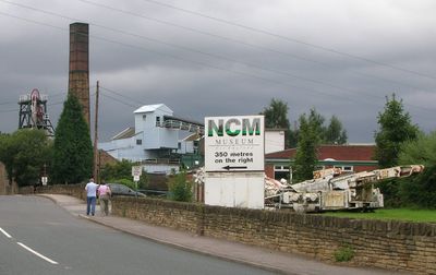
National Coal Mining Museum for England, Mining museum in Overton, England

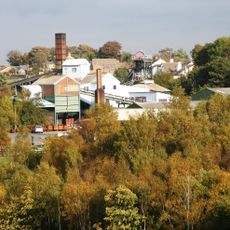
The National Coal Mining Museum is a mining museum located at the former Caphouse Colliery site, displaying exhibits about coal extraction and mining operations. The facility includes preserved underground tunnels, historical machinery, and equipment that document how miners worked and what they encountered below ground.

The museum occupies the Caphouse Colliery site, which began coal extraction in 1754 and became one of the largest mines in the region. After the mine closed in 1985, the location opened as a museum in 1988 to preserve more than 200 years of coal mining heritage.

Former miners lead visitors through the tunnels, sharing personal stories about working underground and how mining shaped the lives of families in the surrounding communities.

Visitors should expect cool and damp conditions underground, so wearing appropriate clothing and sturdy footwear is recommended. Guided tours can be arranged for people with mobility concerns, so those with special requirements should inquire ahead of time.

The museum operates a working pit for demonstration purposes, where historical mining techniques are still applied today to give visitors genuine understanding of the profession. These practical demonstrations show just how physically demanding and difficult the job of a miner truly was.

Location: Sitlington

Inception: 1988

Address: Caphouse Colliery, New Road, Wakefield WF4 4RH

Website: https://ncm.org.uk

GPS coordinates: 53.64330,-1.62110

Latest update: December 8, 2025 19:42

Photos
Around this place
Horbury Town Hall
United Kingdom

Horbury Town Hall

4.5 km
Thornhill Grammar School
United Kingdom

Thornhill Grammar School

2.5 km
Church of St Michael and All Angels, Thornhill
United Kingdom

Church of St Michael and All Angels, Thornhill

2.5 km
Christ Church
United Kingdom

Christ Church

4.4 km
Church of Holy Innocents
United Kingdom

Church of Holy Innocents

4.1 km
Church of St Mary and St Michael
United Kingdom

Church of St Mary and St Michael

3.2 km
Church of St James the Great
United Kingdom

Church of St James the Great

1.8 km
Church of St Michael
United Kingdom

Church of St Michael

3.1 km
Church of St Andrew
United Kingdom

Church of St Andrew

3.2 km
Thornhill Lees Hall
United Kingdom

Thornhill Lees Hall

4.1 km
Savoy Cinema
United Kingdom

Savoy Cinema

1.8 km
St John
United Kingdom

St John

3.4 km
Cleggford Bridge Over River Calder At Junction With Savile Road
United Kingdom

Cleggford Bridge Over River Calder At Junction With Savile Road

4.1 km
Memorial Stone And Base Of Market Cross Opposite Junction With Combs Road
United Kingdom

Memorial Stone And Base Of Market Cross Opposite Junction With Combs Road

2.5 km
6.25 Miles Post, 0.25 Mile West Of Junction With Grange Lane
United Kingdom

6.25 Miles Post, 0.25 Mile West Of Junction With Grange Lane

1.4 km
Calder And Hebble Navigation Milestone At Bridge Over Cut 200 Yards South East Of Lodge Farm
United Kingdom

Calder And Hebble Navigation Milestone At Bridge Over Cut 200 Yards South East Of Lodge Farm

3.1 km
Horbury Viaduct
United Kingdom

Horbury Viaduct

3 km
Winding House, Heapstead and Headstock at Caphouse Colliery
United Kingdom

Winding House, Heapstead and Headstock at Caphouse Colliery

207 m
5.25 Miles Post 200 Yards East Of Junction With Barnlsey Road
United Kingdom

5.25 Miles Post 200 Yards East Of Junction With Barnlsey Road

2.9 km
Milepost Approximately 500 Metres West Of West Bretton Traffic Island
United Kingdom

Milepost Approximately 500 Metres West Of West Bretton Traffic Island

3.3 km
Milestone At Junction With Wakefield Road
United Kingdom

Milestone At Junction With Wakefield Road

3.1 km
Standing cross at Emley
United Kingdom

Standing cross at Emley

3.4 km
Milestone In Front Of Number 30
United Kingdom

Milestone In Front Of Number 30

2.2 km
Milepost Approximately 1000 Metres North East Of West Bretton Traffic Island
United Kingdom

Milepost Approximately 1000 Metres North East Of West Bretton Traffic Island

3.9 km
Milepost Adjacent To White Swan Public House
United Kingdom

Milepost Adjacent To White Swan Public House

1.8 km
Horbury Basin
United Kingdom

Horbury Basin

3.2 km
Milepost 200 Yards South Of Junction With Litherop Lane
United Kingdom

Milepost 200 Yards South Of Junction With Litherop Lane

4.2 km
Milepost Approximately 100 Metres South Of West Bretton Traffic Island
United Kingdom

Milepost Approximately 100 Metres South Of West Bretton Traffic Island

3.6 km
Show the full map
Reviews

Visited this place? Tap the stars to rate it and share your experience / photos with the community! Try now! You can cancel it anytime.

« National Coal Mining Museum for England - Mining museum in Overton, England » is provided by Around Us (aroundus.com). Images and texts are derived from Wikimedia project under a Creative Commons license. You are allowed to copy, distribute, and modify copies of this page, under the conditions set by the license, as long as this note is clearly visible.

Discover hidden gems everywhere you go!

From secret cafés to breathtaking viewpoints, skip the crowded tourist spots and find places that match your style. Our app makes it easy with voice search, smart filtering, route optimization, and insider tips from travelers worldwide. Download now for the complete mobile experience.

Around Us App Screenshot

A unique approach to discovering new places

Le Figaro

All the places worth exploring

France Info

A tailor-made excursion in just a few clicks

20 Minutes