King John's Palace

Log in to your account

AroundUs is a community-driven map of interesting places, built by curious explorers like you. It grows with every review, story, and photo you share.
Connect to save your favorite spots, contribute locations, and create personalized routes.
Continue with Google
Continue with Apple
Continue with X
Continue with Facebook
Continue with email
By continuing, you accept our Terms and Conditions and our Privacy Policy
Create an account
Add to collection
Map
Suggest a change
Share

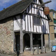
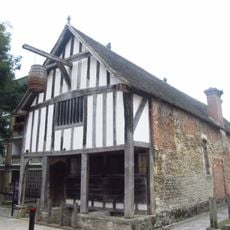
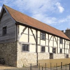
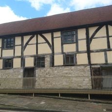
King John's Palace, Medieval merchant house in Southampton, England.

King John's Palace is a stone building in Norman style from the Middle Ages, consisting of two floors with small defensive openings on the ground level and large windows above. The structure combines practical storage space below with living quarters above, which featured a stone fireplace and solid masonry construction.

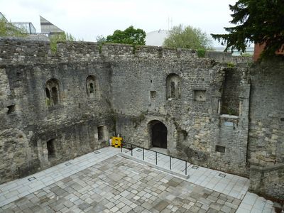
The building was constructed in the 1180s as a private residence for a wealthy merchant and stands as one of the city's oldest surviving structures. It was later incorporated into Southampton's defensive fortifications following a French attack in 1338, shifting from a purely domestic role to a strategic position.

The building shows how wealthy merchants lived and worked in medieval port towns, with separate spaces for storage below and living areas above with good light. The layout reveals the daily rhythm of a merchant's life, combining domestic comfort with the practical needs of trade.

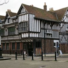
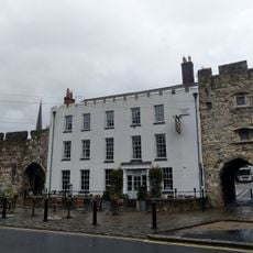
The building sits near Blue Anchor Lane in the center of Southampton and is easy to spot while walking through the old town streets. Visitors can view the exterior details at ground level, including the defensive features and window openings that show how the structure was built for multiple purposes.

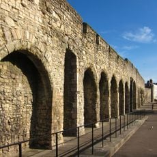
The west wall retains three original archways that once opened directly onto the medieval waterfront, where ships unloaded merchandise from across Europe. These rare surviving features show the direct link between the merchant's home and the busy port life that defined medieval Southampton.

Location: City of Southampton

Architectural style: Norman architecture

GPS coordinates: 50.89950,-1.40666

Latest update: December 13, 2025 11:42

Photos
Around this place
Medieval Merchant's House
United Kingdom

Medieval Merchant's House

148 m
Southampton town walls
United Kingdom

Southampton town walls

15 m
Southampton Tudor House and Garden
United Kingdom

Southampton Tudor House and Garden

48 m
St. Michael's Church, Southampton
United Kingdom

St. Michael's Church, Southampton

106 m
St Joseph Church, Southampton
United Kingdom

St Joseph Church, Southampton

71 m
Pilgrim Fathers' Memorial
United Kingdom

Pilgrim Fathers' Memorial

175 m
The Royal Standard Inn
United Kingdom

The Royal Standard Inn

57 m
The Duke Of Wellington Public House
United Kingdom

The Duke Of Wellington Public House

101 m
Medieval merchant's house and associated deposits at 58 French Street
United Kingdom

Medieval merchant's house and associated deposits at 58 French Street

137 m
Bugle House
United Kingdom

Bugle House

52 m
45, Bugle Street
United Kingdom

45, Bugle Street

70 m
Drinking Fountain
United Kingdom

Drinking Fountain

156 m
Gas Lamp
United Kingdom

Gas Lamp

65 m
47, Bugle Street
United Kingdom

47, Bugle Street

65 m
National Westminster Bank
United Kingdom

National Westminster Bank

178 m
9 And 10, Westgate Street
United Kingdom

9 And 10, Westgate Street

59 m
48, Bugle Street
United Kingdom

48, Bugle Street

65 m
5, St Michael's Square
United Kingdom

5, St Michael's Square

83 m
11 And 13, Bugle Street
United Kingdom

11 And 13, Bugle Street

158 m
88 And 90, French Street
United Kingdom

88 And 90, French Street

178 m
38-42, Bugle Street
United Kingdom

38-42, Bugle Street

91 m
Tudor Merchants Hall
United Kingdom

Tudor Merchants Hall

73 m
Southampton town wall: the West Gate
United Kingdom

Southampton town wall: the West Gate

60 m
Horse Trough
United Kingdom

Horse Trough

134 m
Sections of wall running south along Esplanade from south-west corner of Simnel Street to University Air Squadron Headquarters at south end of Bugle Street. Includes The Arcades, The West Gate, Blue Anchor Postern and Biddles Gate
United Kingdom

Sections of wall running south along Esplanade from south-west corner of Simnel Street to University Air Squadron Headquarters at south end of Bugle Street. Includes The Arcades, The West Gate, Blue Anchor Postern and Biddles Gate

28 m
Town wall: section between Simnal Street and the site of the Bugle Tower excluding the West Gate
United Kingdom

Town wall: section between Simnal Street and the site of the Bugle Tower excluding the West Gate

39 m
8, Westgate Street
United Kingdom

8, Westgate Street

57 m
The Tudor House, St Michael's Square
United Kingdom

The Tudor House, St Michael's Square

40 m
Show the full map
Reviews

Visited this place? Tap the stars to rate it and share your experience / photos with the community! Try now! You can cancel it anytime.

« King John's Palace - Medieval merchant house in Southampton, England » is provided by Around Us (aroundus.com). Images and texts are derived from Wikimedia project under a Creative Commons license. You are allowed to copy, distribute, and modify copies of this page, under the conditions set by the license, as long as this note is clearly visible.

Discover hidden gems everywhere you go!

From secret cafés to breathtaking viewpoints, skip the crowded tourist spots and find places that match your style. Our app makes it easy with voice search, smart filtering, route optimization, and insider tips from travelers worldwide. Download now for the complete mobile experience.

Around Us App Screenshot

A unique approach to discovering new places

Le Figaro

All the places worth exploring

France Info

A tailor-made excursion in just a few clicks

20 Minutes