Poole's Cavern, Show cave in Buxton Country Park, Derbyshire, United Kingdom.
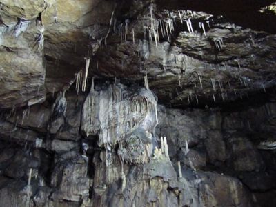
This limestone cave extends approximately 310 meters underground and displays remarkable stalactites, stalagmites, and mineral formations created over two million years through continuous water erosion and mineral deposits.
Archaeological excavations in the 1980s revealed that the cave was inhabited during the Bronze Age around 3,000 to 1,200 BCE, and it became one of the Seven Wonders of the Peak as listed by Thomas Hobbes in the 17th century.
Local legends associate the cave with a 15th-century outlaw named Poole who used it as a hideout, and it gained cultural significance when Mary Queen of Scots allegedly explored the cavern during her visits to the area.
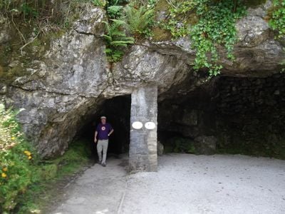
The cave operates daily from 9:45 AM to 5 PM with guided tours every half hour during peak season, featuring modern lighting systems and wheelchair accessibility for the first section of the cavern.
The cave contains distinctively colored 'poached egg' stalagmites caused by minerals from nearby lime-burning activities, and visitors can experience complete darkness when lights are turned off during special heritage tours.
Location: High Peak
Accessibility: Wheelchair limited access
Address: Green Ln, Buxton SK17 9DH, UK
Opening Hours: Monday-Friday 09:45-16:00; Saturday-Sunday 09:45-17:00
Phone: +44129826978
Website: https://poolescavern.co.uk
GPS coordinates: 53.25011,-1.92632
Latest update: October 16, 2025 07:35
Solomon's Temple, Buxton
911 m
Church of St Anne
818 m
Church of Saint Mary the Virgin
968 m
Christ Church
701 m
The Swan Public House
844 m
Sun Inn
884 m
The Octagon
1 km
Hartington Hotel
768 m
Roseleigh Hotel (Number 19) and Sherwood (Number 20)
744 m
Westminster Hotel (Number 21) and Eton House (Number 22)
705 m
Sandringham Hotel
827 m
Cheshire Cheese public house and attached railings
878 m
Cavendish House
894 m
Derby House
862 m
The Argyle
646 m
St Mary's Church War Memorial, Buxton
944 m
Tombstone to John Kane 20 metres south of the Church of Saint Anne
800 m
Grosvenor Mansions Numbers 1, 2 And 3
1 km
Numbers 1-6 and attached walls, railings and gates
622 m
Drinking Fountain
970 m
16 and 17, Broad Walk
790 m
Seven Ways (Number 1) and Somersby (Number 3)
550 m
Bath House
561 m
Walls and gates to Milnthorp Homes
431 m
Two bollards between Numbers 11 and 12
876 m
Lismore Fields Mesolithic and Neolithic settlement
645 m
Number 87 and attached garden walls
105 m
15 lamp standards along north west side of Broad Walk
982 mVisited this place? Tap the stars to rate it and share your experience / photos with the community! Try now! You can cancel it anytime.
Discover hidden gems everywhere you go!
From secret cafés to breathtaking viewpoints, skip the crowded tourist spots and find places that match your style. Our app makes it easy with voice search, smart filtering, route optimization, and insider tips from travelers worldwide. Download now for the complete mobile experience.
A unique approach to discovering new places❞
— Le Figaro
All the places worth exploring❞
— France Info
A tailor-made excursion in just a few clicks❞
— 20 Minutes