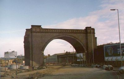
Horns Bridge, Railway bridge in Chesterfield, England.
Horns Bridge is a railway bridge in Chesterfield that crosses multiple transportation routes using seven brick arches and lattice girder construction. The structure spans over rail lines, roads, and two rivers at different levels, serving as a major engineering link in the area.
The current railway crossing opened in 1897, replacing an earlier brick arch structure from 1840 that had served the area. This newer version operated until 1957, reflecting changes in transportation infrastructure needs over several decades.
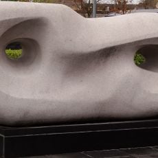
The modern sculpture 'Growth' on the traffic island at Horns Bridge represents the industrial legacy and future development of Chesterfield.
The location sits at a busy junction of rails, roads, and waterways, so expect active traffic from multiple directions. Visitors should be aware of ongoing transportation activity and plan their visit accordingly.
The area frequently experiences flooding during heavy rainfall and storms, making the spot prone to water challenges. The combination of height and proximity to both rivers creates regular conditions where water levels rise significantly.
Official opening: February 1897
GPS coordinates: 53.23090,-1.42153
Latest update: December 13, 2025 11:47
Church of St Mary and All Saints, Chesterfield
606 m
Chesterfield Museum and Art Gallery
649 m
The Post Office
780 m
United Reformed Church
858 m
Central Methodist Church
829 m
Unitarian Chapel
769 m
Cemetery Church And Chapel At Spital Cemetery
382 m
The Spread Eagle Public House
500 m
War Memorial in Churchyard to North East of St Mary's Church
655 m
Stephenson Memorial Hall
640 m
The Peacock Inn
755 m
The Royal Oak Inn
650 m
Winding Wheel
733 m
Curved Reclining Form (Rosewall)
874 m
The Market Hall
723 m
William And Glyn's Bank And Bank Chambers
671 m
9, Beetwell Street
504 m
National Westminster Bank
831 m
War Memorial and Steps in Front of Chesterfield Town Hall
945 m
69-79 Saltergate
909 m
42, St Mary's Gate
469 m
Physiotherpay Department Of Royal Hospital
902 m
69 And 71, Low Pavement
765 m
87, New Square
832 m
The Town Pump
717 m
43, Low Pavement
678 m
41, Low Pavement
673 m
Holywell Cross Post Office
832 mVisited this place? Tap the stars to rate it and share your experience / photos with the community! Try now! You can cancel it anytime.
Discover hidden gems everywhere you go!
From secret cafés to breathtaking viewpoints, skip the crowded tourist spots and find places that match your style. Our app makes it easy with voice search, smart filtering, route optimization, and insider tips from travelers worldwide. Download now for the complete mobile experience.
A unique approach to discovering new places❞
— Le Figaro
All the places worth exploring❞
— France Info
A tailor-made excursion in just a few clicks❞
— 20 Minutes