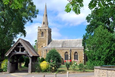
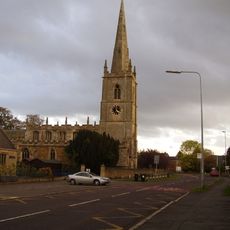
All Saints Church, Medieval church in Barrowby, England
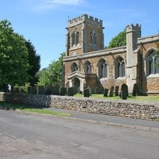
All Saints Church is a medieval church built from limestone and ironstone, standing on a hilltop overlooking the Vale of Belvoir with Gothic architectural elements throughout. The circular churchyard surrounding it provides pathways for walking and benches for resting.
The church appears in the Domesday Book of 1086, with the current building constructed around the 13th century and incorporating Saxon carvings into its design. This blend of early medieval history and Gothic architecture shapes the church's character.
The church serves as a gathering place for religious ceremonies and community events in the village. Local memorials and war graves reflect its role as a keeper of shared memories for Barrowby residents.
The church building is typically locked outside of service times, but the churchyard is accessible for visitors to explore freely. Interpretive panels around the grounds provide information about the site's history and features.
The churchyard is home to over 40 lichen species and serves as a roost for bats, making it an important wildlife habitat. Native plants like cowslip and black knapweed thrive among the graves, turning the cemetery into a living sanctuary.
Location: Barrowby
Inception: 13 century
Architectural style: English Gothic architecture
GPS coordinates: 52.91870,-0.69470
Latest update: December 14, 2025 16:43
Angel and Royal Hotel
3.5 km
Roman Catholic Church of St Mary
3.3 km
Westgate Hall
3.5 km
Church of St Sebastian
2.5 km
Church of Saint Lawrence
2.6 km
Blue Pig Inn
3.5 km
White Swan Public House
237 m
Blue Ram Inn
3.5 km
2, 4 And 6, North Parade
3.3 km
Denton Canal Bridge (No 65 On Grantham Canal)
2.6 km
7-9, Westgate
3.5 km
21A And 21B, Swingate
3.5 km
95 Westgate
3.5 km
24, North Parade
3.3 km
74, North Parade
3.3 km
Vine House
3.5 km
Grantham market cross
3.5 km
46, North Parade
3.3 km
Gateway And Screen Wall 1200 Metres North West Of Harlaxton Manor
3.5 km
8, Albion Street
3.4 km
Grantham Canal, Vincents Bridge On Grantham Canal
2.8 km
North House And Left Hand Section Of Premises Occupied By Electricity Board
3.3 km
5, Market Place
3.4 km
Holly House
246 m
3-11, North Parade
3.3 km
11, Swingate
3.5 km
1, 2, 3 And 3A, Westgate
3.5 km
Conduit House, Market Place
3.4 kmVisited this place? Tap the stars to rate it and share your experience / photos with the community! Try now! You can cancel it anytime.
Discover hidden gems everywhere you go!
From secret cafés to breathtaking viewpoints, skip the crowded tourist spots and find places that match your style. Our app makes it easy with voice search, smart filtering, route optimization, and insider tips from travelers worldwide. Download now for the complete mobile experience.
A unique approach to discovering new places❞
— Le Figaro
All the places worth exploring❞
— France Info
A tailor-made excursion in just a few clicks❞
— 20 Minutes