Sittingbourne and Kemsley Light Railway, Heritage narrow-gauge railway in Kent, England
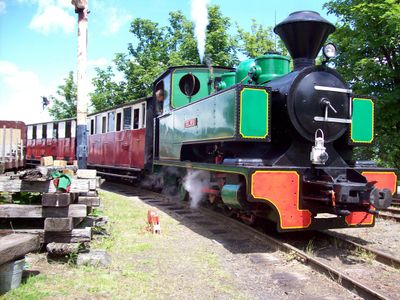
The Sittingbourne and Kemsley Light Railway is a narrow-gauge heritage railway in Kent that spans just over two miles and operates along its original route. The line features preserved station buildings, period trains, and infrastructure that reflect its industrial origins as a working goods line.
This railway was created in the early 1900s to move supplies between a local dock and a paper mill, supporting industrial operations in the region. It later passed to volunteer operators who transformed it into a public heritage line accessible to railway enthusiasts.
The railway takes its name from the two locations it originally connected, both tied to industrial activity and goods movement. Today visitors experience how this working line has transformed into a space where the industrial past is kept alive through regular operations.
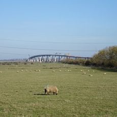
The railway operates on set days during its season and can be reached via its main station in town. Visitors should come prepared for outdoor travel with appropriate clothing since much of the journey passes through open countryside.
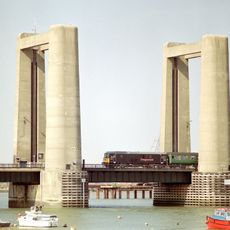
A striking feature is a large reinforced concrete viaduct that crosses the route, built in the early 1900s and counting among the longest of its kind in the country. This structure continues to carry trains today as part of the regular service.
Location: Kent
Address: Kemsley Down Station, Sittingbourne ME10 2JG
Website: http://sklr.net
GPS coordinates: 51.35750,0.75361
Latest update: December 9, 2025 18:47
Sheppey Crossing
3.7 km
Kingsferry Bridge
3.7 km
Church of All Saints, Murston
1.7 km
Church of the Holy Trinity
2.3 km
The Three Hats Inn
1.7 km
Church of St Nicholas
3.9 km
Church of St Peter and St Paul
4.5 km
Church of St Michael
2.2 km
Church of St Bartholomew
3 km
Church of St Lawrence
2.8 km
Church of St Giles
2.3 km
Church of St John the Baptist
4.4 km
Church of All Saints
2.8 km
Parish Church of the Holy Trinity
962 m
Parsonage Farm House
3.7 km
Great Grovehurst Farmhouse
1.6 km
Frognal Farmhouse And Garden Wall
3.8 km
Little Murston Farmhouse
1.5 km
Kingshill Farmhouse
3.1 km
Pheasants Farmhouse
2.1 km
Barn 50 Yards West Of Frognal Farmhouse
3.7 km
245 And 247, Borden Lane
4.3 km
Traditional Agricultural Barn
2.9 km
Tunstall House
4.5 km
Milestone, Canterbury Road, by No. 201 "The Milestone"
2.5 km
Milestone, London Road, Radfield, E of public footpath
3.6 km
Milestone, High Street, SW corner of St Michael's Churchyard, in pedestrian zone
2.2 km
Milestone, Fox Cottage, Chestnut Street, just E of town between J5 of M2 and Key Street roundabout
4.8 kmVisited this place? Tap the stars to rate it and share your experience / photos with the community! Try now! You can cancel it anytime.
Discover hidden gems everywhere you go!
From secret cafés to breathtaking viewpoints, skip the crowded tourist spots and find places that match your style. Our app makes it easy with voice search, smart filtering, route optimization, and insider tips from travelers worldwide. Download now for the complete mobile experience.
A unique approach to discovering new places❞
— Le Figaro
All the places worth exploring❞
— France Info
A tailor-made excursion in just a few clicks❞
— 20 Minutes