Hospital of St Lawrence, Bodmin
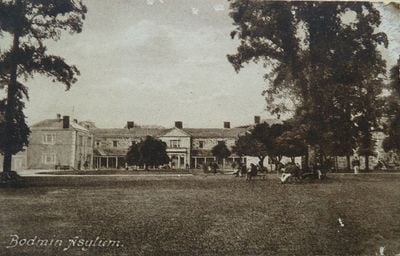
Hospital of St Lawrence, Bodmin, Grade II* listed former mental health hospital in Bodmin, England
The Hospital of St Lawrence is a Grade II* listed hospital complex in Bodmin, England, featuring buildings from the 19th century. The site displays a central block with radiating wings designed according to star-shaped architectural principles by John Foulston in 1818.
The facility opened in 1818 as Cornwall County Asylum to address mental health care needs, serving this purpose until its closure in 2002. William Robert Hicks introduced improved treatment methods in the 1840s that changed medical practices on site.
The hospital kept detailed medical records now stored at Kresen Kernow, documenting treatments and patient experiences across nearly two centuries. These archives offer insight into how medical care and daily life evolved within its walls.
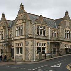
The site is no longer open to the public as it closed, with only certain sections protected under listed status. Visitors should respect the boundaries of the private grounds when viewing from outside.
The grounds held a dedicated burial site from 1850 to 1859 for deceased patients before interments moved to Bodmin Cemetery. This practice reveals much about patient care and dignity standards of that era.
Location: Bodmin
Inception: 1818
Architects: John Foulston
GPS coordinates: 50.46950,-4.73628
Latest update: December 12, 2025 14:26
Bodmin Jail
800 m
Bodmin Jail
821 m
Barley Sheaf Public House And Attached Mounting Block
889 m
Gilbert's Monument
981 m
Methodist Chapel
926 m
Old Library
848 m
20, Lower Bore Street
789 m
49 And 50, Fore Street
1.1 km
53, Fore Street
1.1 km
80, Fore Street
972 m
Lloyds Bank
1.1 km
Chestnuts
958 m
Bodmin Gaol Chaplaincy And Governor's House And Attached Iron Railings
844 m
55 And 57, Fore Street
1.1 km
Berrycombe Cross
876 m
Former Methodist Sunday School
954 m
96, Fore Street
902 m
Market House
1.1 km
No 42 With Attached Stables And Remains Of Barn
1.1 km
67 And 69, Fore Street
1 km
22, Lower Bore Street
783 m
28, Lower Bore Street
760 m
Forecourt Steps And Walls To Methodist Chapel
942 m
7, Lower Bore Street
872 m
71, Fore Street
1 km
64, Fore Street
1 km
Former Naval Officers Quarters Including Boundary Walls To East
798 m
Belgian Refugees WWI Memorial Tablet, Bodmin
845 mVisited this place? Tap the stars to rate it and share your experience / photos with the community! Try now! You can cancel it anytime.
Discover hidden gems everywhere you go!
From secret cafés to breathtaking viewpoints, skip the crowded tourist spots and find places that match your style. Our app makes it easy with voice search, smart filtering, route optimization, and insider tips from travelers worldwide. Download now for the complete mobile experience.
A unique approach to discovering new places❞
— Le Figaro
All the places worth exploring❞
— France Info
A tailor-made excursion in just a few clicks❞
— 20 Minutes