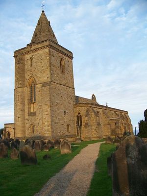
Church of St Oswald, Lythe, Medieval church in Lythe, England
The Church of St Oswald sits at the top of Lythe Bank and features Gothic architecture with a prominent tower visible from both land and sea. The building contains interior spaces with multiple altars and windows that allow light to fill the spacious choir and nave.
The building shows elements from the early 13th century but underwent changes in the late 18th century. Architect Sir Walter Tapper carried out a comprehensive restoration in the early 20th century.
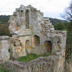
The church holds a collection of Anglo-Scandinavian carved stones that reflect the strong Viking-era influence once present in this region. These artifacts show how this coastal community connected with northern European cultures during the early medieval period.
The building can be visited daily from 8:30 AM until dusk, with parking available in the adjacent field or along the nearby lane. The ground around it can be slippery, especially in wet weather, so sturdy shoes are recommended.
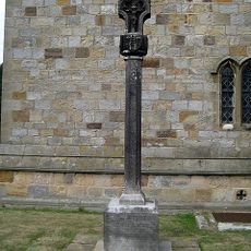
The churchyard holds a listed memorial that honors 17 local casualties from World War I and seven unidentified sailors who died at sea. These names represent a local story of loss from a conflict that deeply affected this coast.
Location: Lythe
Inception: 13 century
Website: https://achurchnearyou.com/church/19381/more-information
GPS coordinates: 54.50660,-0.68856
Latest update: December 14, 2025 18:06
Mulgrave Castle
1.8 km
Lythe War Memorial
14 m
The Fox and Hounds Public House
2 km
Milestone, Lythe Bank, N of Sandsend
613 m
Alum works at Kettleness
3.3 km
Edwardian Shelter 15 Metres West Of Cliff Lift
4.6 km
Raw Pastures Farmhouse
2.1 km
Kettleness Farmhouse
3.2 km
Abingdon House and house adjoining to west
454 m
High Farmhouse
502 m
Milestone, High Street East Barnby, jct with Ashton Lane and Maltby Lane
2.2 km
Oakdene
363 m
Barnby Tofts Farmhouse
3 km
Middle Farmhouse
470 m
Raven Hill Farmhouse And Barn Adjoining
1.8 km
Greystone Farmhouse
3 km
Cliff House
3 km
Overdale Farmhouse
1.1 km
Low Farmhouse
405 m
Art Nouveau Shelter 30 Metres West Of Cliff Lift
4.5 km
Standing stone on Brockrigg known as Wade's Stone, 420m south east of Brockrigg Farm
2.4 km
The Wishing Chair Cross cross base at junction of Stakesby Road and Westbourne Road
4.1 km
Foss Castle
2.3 km
Milestone, nr Bends sign
4.4 km
Milestone, Guisborough Road opp track to farm
3.9 km
Milestone, Guisborough Road, just E of A169 TI
3.8 km
Milestone, Castle Road, Whitby
4.2 km
Fairfax Farm House
2.1 kmVisited this place? Tap the stars to rate it and share your experience / photos with the community! Try now! You can cancel it anytime.
Discover hidden gems everywhere you go!
From secret cafés to breathtaking viewpoints, skip the crowded tourist spots and find places that match your style. Our app makes it easy with voice search, smart filtering, route optimization, and insider tips from travelers worldwide. Download now for the complete mobile experience.
A unique approach to discovering new places❞
— Le Figaro
All the places worth exploring❞
— France Info
A tailor-made excursion in just a few clicks❞
— 20 Minutes