Enable Location

We need your location to show you interesting places around you

Discover nearby places

Find interesting locations and hidden gems around you

Precise directions

Get accurate directions and distances to places

Your location is never shared with other users. It's only used when you tap the location button.

St Clere

Log in to your account

Start exploring — it's free

Trusted by 62,161 travelers worldwide

Continue with Google
Continue with Apple
or

We will send you a code to connect

By continuing, you accept our Terms and Conditions and our Privacy Policy

Check your inbox

We've sent a pincode in your inbox. Please enter the code below.

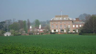
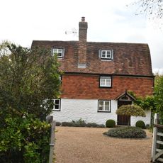
St Clere, Grade I listed country house in Kemsing, England

St Clere is a three-storey brick building with a basement and attic featuring a five-bay front facade topped with a 19th-century central porch. The structure preserves a mix of classical elements and later additions incorporated during various renovation periods.

The estate was originally known as Aldham dating to the 13th century before Sir John Sedley rebuilt it into its current form in 1625. Its long ownership history passed through various wealthy families of the region over the centuries.

The interior features a notable chimneypiece designed by Sir John Soane that was relocated from the old Bank of England. This element reflects a direct connection to one of London's most important financial buildings.

The building is protected as a Grade I listed structure, meaning any alterations are strictly regulated to preserve its historical characteristics. Access to the property may be limited and prior arrangements should be confirmed before visiting.

The estate served as the main filming location for the 1980 British mystery film The Mirror Crack'd starring Angela Lansbury as Miss Marple. This cinematic connection remains a notable detail for visitors familiar with the classic detective story.

The community of curious travelers

AroundUs brings together thousands of curated places, local tips, and hidden gems, enriched daily by 60,000 contributors worldwide.

Start exploring
Location
GPS coordinates
51.30940,0.26105
Latest update
December 12, 2025 14:40
Around this place
Dorton House
United Kingdom

Dorton House

4 km
Oldbury rock shelters
United Kingdom

Oldbury rock shelters

2.7 km
West Kingsdown Windmill
United Kingdom

West Kingsdown Windmill

3.2 km
Church of St Peter and St Paul, Seal
United Kingdom

Church of St Peter and St Paul, Seal

3.4 km
Church of St Peter
United Kingdom

Church of St Peter

2.8 km
Church of St George
United Kingdom

Church of St George

3.5 km
Church of St Mary
United Kingdom

Church of St Mary

2.1 km
Church of St Mary
United Kingdom

Church of St Mary

4.3 km
Church of Saint Mary the Virgin
United Kingdom

Church of Saint Mary the Virgin

2 km
Church of Saint Edmund
United Kingdom

Church of Saint Edmund

4.2 km
The Bull Hotel
United Kingdom

The Bull Hotel

3.5 km
The Three Post Boys Public House
United Kingdom

The Three Post Boys Public House

3.5 km
The Post Office
United Kingdom

The Post Office

3.4 km
Kemsing War Memorial
United Kingdom

Kemsing War Memorial

2.2 km
The George And Dragon Public House
United Kingdom

The George And Dragon Public House

3.4 km
Two milestones at West Kingsdown
United Kingdom

Two milestones at West Kingsdown

3.6 km
Noah's Ark
United Kingdom

Noah's Ark

2.3 km
Old Forge House
United Kingdom

Old Forge House

3 km
Ightham War Memorial
United Kingdom

Ightham War Memorial

3 km
Milestone on Pilgrim's Way
United Kingdom

Milestone on Pilgrim's Way

3 km
Milepost, London Road, opp "Sandsford House", outside "Ajacio", W of School Lane
United Kingdom

Milepost, London Road, opp "Sandsford House", outside "Ajacio", W of School Lane

3.5 km
Milestone, Old London Road, W of jct with High Street, opp. Coach Lodge
United Kingdom

Milestone, Old London Road, W of jct with High Street, opp. Coach Lodge

3.4 km
Milestone, Maidstone Road, Brough Green, by church
United Kingdom

Milestone, Maidstone Road, Brough Green, by church

3.7 km
Milestone, Sevenoaks Road, in wall of "Oakenhurst"
United Kingdom

Milestone, Sevenoaks Road, in wall of "Oakenhurst"

3.5 km
Milestone, Maidstone Road, E of village
United Kingdom

Milestone, Maidstone Road, E of village

3.3 km
Milestone, Seal Road, by No 206, 40m W of jct with Filmer Lane
United Kingdom

Milestone, Seal Road, by No 206, 40m W of jct with Filmer Lane

4.3 km
Milepost, London Road, by Holly Lodge, W of Ash Lane
United Kingdom

Milepost, London Road, by Holly Lodge, W of Ash Lane

2.8 km
Guidestone, Pilgrims Way, to W and adjoining track to Kemsing Down Nature Reserve, and jct with Childsbridge Lane
United Kingdom

Guidestone, Pilgrims Way, to W and adjoining track to Kemsing Down Nature Reserve, and jct with Childsbridge Lane

3 km
Show the full map
« St Clere - Grade I listed country house in Kemsing, England » is provided by Around Us (aroundus.com). Images and texts are derived from Wikimedia project under a Creative Commons license. You are allowed to copy, distribute, and modify copies of this page, under the conditions set by the license, as long as this note is clearly visible.

Discover hidden gems everywhere you go!

From secret cafés to breathtaking viewpoints, skip the crowded tourist spots and find places that match your style. Our app makes it easy with voice search, smart filtering, route optimization, and insider tips from travelers worldwide. Download now for the complete mobile experience.

Around Us App Screenshot

A unique approach to discovering new places

Le Figaro

All the places worth exploring

France Info

A tailor-made excursion in just a few clicks

20 Minutes

Around Us
Travel Guide & Maps
Download

Send to your phone

QR Code
1

Open the camera app on your mobile.

2

Point at the QR code with your camera. A notification will appear.

3

Tap the notification to open the link.