Enable Location

We need your location to show you interesting places around you

Discover nearby places

Find interesting locations and hidden gems around you

Precise directions

Get accurate directions and distances to places

Your location is never shared with other users. It's only used when you tap the location button.

St Mary and St Barlock's Church, Norbury

Log in to your account

Start exploring — it's free

Trusted by 61,891 travelers worldwide

Continue with Google
Continue with Apple
or

We will send you a code to connect

By continuing, you accept our Terms and Conditions and our Privacy Policy

Check your inbox

We've sent a pincode in your inbox. Please enter the code below.

St Mary and St Barlock's Church, Norbury

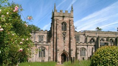
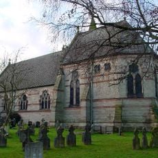
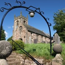
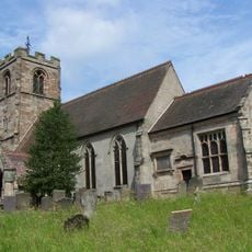
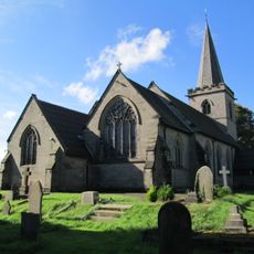
St Mary and St Barlock's Church, Norbury, Medieval church in Norbury, England

St Mary and St Barlock's Church is a medieval church building in Norbury with a chancel approximately 46 feet long and a nave approximately 49 feet long. The tower contains three bells from different centuries that remain in working order for the church community.

Construction of the church began in 1295 with the chancel built by the Fitzherbert family to replace an earlier Norman church. That earlier building had been established around 1179 by John Fitzherbert and served the community for generations.

The chancel windows display grisaille glass with coats of arms and geometric patterns that show early medieval English craftsmanship. These fine details tell the story of the families who built and maintained the building over centuries.

The building underwent comprehensive restoration in 2004, with specialists carefully cleaning and preserving the historic stained glass windows. Visitors should be aware of narrow staircases and low doorways that are typical features of medieval churches of this period.

The dedication to Saint Barlock refers to Saint Finbarr of Cork, revealing an Irish connection to this English parish church. This uncommon dedication likely stems from John Fitzherbert's earlier involvement in Irish administration, creating a personal link between his lands and the saint.

The community of curious travelers

AroundUs brings together thousands of curated places, local tips, and hidden gems, enriched daily by 60,000 contributors worldwide.

Start exploring
Inception
12 century
GPS coordinates
52.97880,-1.81455
Latest update
December 14, 2025 18:13
Around this place
Alton Towers Waterpark
United Kingdom

Alton Towers Waterpark

4.2 km
Wootton Lodge
United Kingdom

Wootton Lodge

3.3 km
Norbury Manor
United Kingdom

Norbury Manor

325 m
St John the Baptist's Church, Mayfield
United Kingdom

St John the Baptist's Church, Mayfield

3.7 km
Church of All Saints
United Kingdom

Church of All Saints

2.9 km
Church of St Peter
United Kingdom

Church of St Peter

3.1 km
Church of St Peter
United Kingdom

Church of St Peter

1.4 km
St Mary's Church
United Kingdom

St Mary's Church

3.6 km
Church of St Michael
United Kingdom

Church of St Michael

3.3 km
Quixhill Bridge
United Kingdom

Quixhill Bridge

2.8 km
Ellastone Bridge
United Kingdom

Ellastone Bridge

553 m
War Memorial South West of Denstone College
United Kingdom

War Memorial South West of Denstone College

4.2 km
Rocester Bridge
United Kingdom

Rocester Bridge

3.4 km
Tutbury Mill
United Kingdom

Tutbury Mill

3.4 km
Snelston War Memorial
United Kingdom

Snelston War Memorial

2.8 km
Village Cross And Drinking Fountain
United Kingdom

Village Cross And Drinking Fountain

3.1 km
Milepost At Ngr Sk 1074 3992
United Kingdom

Milepost At Ngr Sk 1074 3992

3 km
Milepost At Ngr Sk 1148 4353
United Kingdom

Milepost At Ngr Sk 1148 4353

1.6 km
Milepost Approximately 10 Yards North West Of Red House At Ngr Sk 1400 4412
United Kingdom

Milepost Approximately 10 Yards North West Of Red House At Ngr Sk 1400 4412

2.2 km
Milepost Opposite Stone Bank
United Kingdom

Milepost Opposite Stone Bank

3.2 km
Ousley Cross Base And Shaft At Ngr Sk 1255 4452
United Kingdom

Ousley Cross Base And Shaft At Ngr Sk 1255 4452

2.1 km
Milepost Approximately 50 Yards South West Of Prestwood Lane
United Kingdom

Milepost Approximately 50 Yards South West Of Prestwood Lane

1.9 km
Stubwood Methodist Chapel, Forecourt Walls, Railings And Gate
United Kingdom

Stubwood Methodist Chapel, Forecourt Walls, Railings And Gate

3.7 km
Cross Approximately 15 Yards South Of South Aisle Of Church Of St John Baptist
United Kingdom

Cross Approximately 15 Yards South Of South Aisle Of Church Of St John Baptist

3.7 km
Milepost At Ngr Sk 1257 4360
United Kingdom

Milepost At Ngr Sk 1257 4360

1.2 km
Milepost At Ngr Sk 1099 4123
United Kingdom

Milepost At Ngr Sk 1099 4123

1.9 km
Milepost, near Eid Low, between Wootton & Ramshorn
United Kingdom

Milepost, near Eid Low, between Wootton & Ramshorn

4.5 km
Milepost, Denstone
United Kingdom

Milepost, Denstone

3.2 km
Show the full map
« St Mary and St Barlock's Church, Norbury - Medieval church in Norbury, England » is provided by Around Us (aroundus.com). Images and texts are derived from Wikimedia project under a Creative Commons license. You are allowed to copy, distribute, and modify copies of this page, under the conditions set by the license, as long as this note is clearly visible.

Discover hidden gems everywhere you go!

From secret cafés to breathtaking viewpoints, skip the crowded tourist spots and find places that match your style. Our app makes it easy with voice search, smart filtering, route optimization, and insider tips from travelers worldwide. Download now for the complete mobile experience.

Around Us App Screenshot

A unique approach to discovering new places

Le Figaro

All the places worth exploring

France Info

A tailor-made excursion in just a few clicks

20 Minutes

Around Us
Travel Guide & Maps
Download

Send to your phone

QR Code
1

Open the camera app on your mobile.

2

Point at the QR code with your camera. A notification will appear.

3

Tap the notification to open the link.