Enable Location

We need your location to show you interesting places around you

Discover nearby places

Find interesting locations and hidden gems around you

Precise directions

Get accurate directions and distances to places

Your location is never shared with other users. It's only used when you tap the location button.

Stone Gappe

Log in to your account

Start exploring — it's free

Trusted by 62,419 travelers worldwide

Continue with Google
Continue with Apple
or

We will send you a code to connect

By continuing, you accept our Terms and Conditions and our Privacy Policy

Check your inbox

We've sent a pincode in your inbox. Please enter the code below.

Stone Gappe

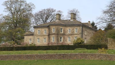
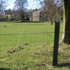
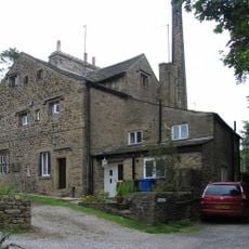
Stone Gappe, Grade II* listed house in Lothersdale, England.

Stone Gappe is a three-story residence built of hammer-dressed stone with five symmetrical bays and a hipped slate roof. The house displays characteristic features of 18th-century English country architecture and remains protected as a listed building.

Built in 1725 for William Bawdwen, the house represents the architectural tradition of English country estates of that era. Original interior features, particularly the staircases, have survived and reflect the craftsmanship typical of the period.

Stone Gappe hosted Charlotte Brontë during her time as a governess in 1839, an experience that touched her deeply and shaped her later writing. Walking through the rooms today, visitors can imagine the daily life of one of England's most celebrated authors during this period.

The building is located in the small village of Lothersdale and can be viewed from the exterior. The site requires some planning to reach, as the area sits away from major transport hubs, but the journey is worthwhile for anyone interested in historical architecture.

The composer Frederick Delius visited the house on several occasions when Dr. J Black and Clare Delius resided there. This musical connection is often overlooked by visitors today, adding another layer to the house's history.

The community of curious travelers

AroundUs brings together thousands of curated places, local tips, and hidden gems, enriched daily by 60,000 contributors worldwide.

Start exploring
Location
GPS coordinates
53.90790,-2.05032
Latest update
December 12, 2025 12:06
Around this place
Lund's Tower
United Kingdom

Lund's Tower

3.6 km
Wainman's Pinnacle
United Kingdom

Wainman's Pinnacle

3.3 km
Church of Holy Trinity
United Kingdom

Church of Holy Trinity

2.7 km
Christ Church
United Kingdom

Christ Church

534 m
Church of St Mary
United Kingdom

Church of St Mary

4.1 km
Milestone 200 Metres West Of Glusburn Institute
United Kingdom

Milestone 200 Metres West Of Glusburn Institute

3.3 km
Black Bull Inn
United Kingdom

Black Bull Inn

4.1 km
Sutton-in-Craven War Memorial
United Kingdom

Sutton-in-Craven War Memorial

4.1 km
Wellington HZ 251 Crash Memorial, Low Bradley
United Kingdom

Wellington HZ 251 Crash Memorial, Low Bradley

3.7 km
Milestone Near New Hall Farm At Ngr 985441
United Kingdom

Milestone Near New Hall Farm At Ngr 985441

2.3 km
Farnhill Jubilee Tower
United Kingdom

Farnhill Jubilee Tower

4.1 km
Milestone At Junction Of Main Street And Grange Road
United Kingdom

Milestone At Junction Of Main Street And Grange Road

4 km
Leeds And Liverpool Canal Farnhill Bridge 183A At Se0020 4663
United Kingdom

Leeds And Liverpool Canal Farnhill Bridge 183A At Se0020 4663

3.5 km
Dale End Mill
United Kingdom

Dale End Mill

845 m
Porridge Stoup
United Kingdom

Porridge Stoup

3.2 km
Carr Head Hall
United Kingdom

Carr Head Hall

1.6 km
Boundary Stone At Ngr 9485 4856
United Kingdom

Boundary Stone At Ngr 9485 4856

3.4 km
Milestone Near Hey Farm At Ngr 958428
United Kingdom

Milestone Near Hey Farm At Ngr 958428

3.1 km
Milestone 300 M North Of Farnhill Bridge, On A629
United Kingdom

Milestone 300 M North Of Farnhill Bridge, On A629

3.6 km
Boundary Stone Opposite Bridge End Farm
United Kingdom

Boundary Stone Opposite Bridge End Farm

2.9 km
Milestone At Junction With Lane Ends Lane
United Kingdom

Milestone At Junction With Lane Ends Lane

2 km
Trappes Hall
United Kingdom

Trappes Hall

4 km
Wellington HZ 251 Memorial, Low Bradley
United Kingdom

Wellington HZ 251 Memorial, Low Bradley

3.8 km
Guidestone, E of Lothersdale
United Kingdom

Guidestone, E of Lothersdale

565 m
Guidestone, jct Ings Lane into Low Bradley
United Kingdom

Guidestone, jct Ings Lane into Low Bradley

3.7 km
Base Of Carleton Cross At Ngr 9630 4760
United Kingdom

Base Of Carleton Cross At Ngr 9630 4760

1.9 km
Guidestone, Staggered X Rds Farnhill – Cononley
United Kingdom

Guidestone, Staggered X Rds Farnhill – Cononley

3.5 km
Milestone, NE of Lothersdale
United Kingdom

Milestone, NE of Lothersdale

756 m
Show the full map
« Stone Gappe - Grade II* listed house in Lothersdale, England » is provided by Around Us (aroundus.com). Images and texts are derived from Wikimedia project under a Creative Commons license. You are allowed to copy, distribute, and modify copies of this page, under the conditions set by the license, as long as this note is clearly visible.

Discover hidden gems everywhere you go!

From secret cafés to breathtaking viewpoints, skip the crowded tourist spots and find places that match your style. Our app makes it easy with voice search, smart filtering, route optimization, and insider tips from travelers worldwide. Download now for the complete mobile experience.

Around Us App Screenshot

A unique approach to discovering new places

Le Figaro

All the places worth exploring

France Info

A tailor-made excursion in just a few clicks

20 Minutes

Around Us
Travel Guide & Maps
Download

Send to your phone

QR Code
1

Open the camera app on your mobile.

2

Point at the QR code with your camera. A notification will appear.

3

Tap the notification to open the link.