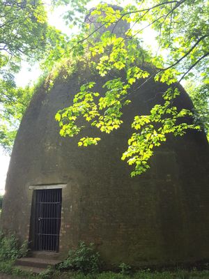
Rockingham Kiln, Grade II* listed pottery kiln in Swinton, England
The Rockingham Kiln is a striking structure with a distinctive bottle shape built from red brick, rising about 17 meters high. It formed the heart of a porcelain factory and displays the solid construction typical of 19th-century industrial production facilities.
The kiln was built in 1815 as the core of a porcelain factory that produced decorative wares until it shut down in 1842 due to financial troubles. This closure left the structure as a rare survivor from an era of intense pottery production in England.
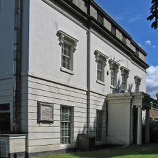
The factory earned renown for crafting fine porcelain pieces destined for royal households and wealthy collectors. Visitors walking around the structure can sense the pride that once surrounded this center of skilled craftsmanship.
The kiln is best viewed from the outside, where its full form and scale are clearly visible from the surrounding area. Local information can help clarify current access conditions if you plan to visit the site itself.
This kiln is one of the few surviving pottery kilns from that era still standing in England, and possibly the only one remaining in Yorkshire. It thus represents a rare window into the region's industrial past.
Location: Rotherham
Part of: Swinton Pottery (The Rockingham Works), 310m and 120m north west of Keeper's Cottage
GPS coordinates: 53.48420,-1.33759
Latest update: December 11, 2025 18:02
The Rockingham Mausoleum
3.2 km
Hoober Observatory
2.9 km
Wath Hall
2.2 km
Christ Church
2.8 km
Church of All Saints
2.2 km
Church of St Mary
2.9 km
Church of St Margaret
1.3 km
Mausoleum On East Side Of Newhill Park
1.7 km
Roman Ridge: section 300yds (270m) long N of Birchwood (E of Chemical Cottages)
883 m
Milepost Opposite Warren House Cottage
1.4 km
Grand Cinema
2.6 km
Mexborough Station And Station House
3.3 km
Hall Farmhouse
1.8 km
Roman Ridge: section 520yds (480m) E of Dyson's Cottage to Long Plantation
916 m
Hoober Hall
2.5 km
Swinton House
1.3 km
15, Fitzwilliam Street
1.3 km
Mausoleum Lodge
3 km
Milepost Approximately 100 Metres To North West Of Junction With Highthron Road
2.4 km
Hall Farmhouse
1.9 km
Roman Ridge: section 140yds (130m) long in Dyson's Plantation
760 m
Milestone Approximately 30 Metres To North West Of Mausoleum Lodge
3 km
Milepost Approximately 45 Metres South West Of Junction With Abdy Lane
498 m
Swinton Hall
1.3 km
Hawthorne Farmhouse
1.3 km
Milepost Approximately 350 Metres To East Of Junction With Warren Vale
1 km
Roman Ridge: section 400yds (370m) long S of Abdy Farm
1.1 km
Milestone, in parapet of bridge over disused canal
2.2 kmVisited this place? Tap the stars to rate it and share your experience / photos with the community! Try now! You can cancel it anytime.
Discover hidden gems everywhere you go!
From secret cafés to breathtaking viewpoints, skip the crowded tourist spots and find places that match your style. Our app makes it easy with voice search, smart filtering, route optimization, and insider tips from travelers worldwide. Download now for the complete mobile experience.
A unique approach to discovering new places❞
— Le Figaro
All the places worth exploring❞
— France Info
A tailor-made excursion in just a few clicks❞
— 20 Minutes