Enable Location

We need your location to show you interesting places around you

Discover nearby places

Find interesting locations and hidden gems around you

Precise directions

Get accurate directions and distances to places

Your location is never shared with other users. It's only used when you tap the location button.

Church of St Hubert

Log in to your account

Start exploring — it's free

Trusted by 63,023 travelers worldwide

Continue with Google
Continue with Apple
or

We will send you a code to connect

By continuing, you accept our Terms and Conditions and our Privacy Policy

Check your inbox

We've sent a pincode in your inbox. Please enter the code below.

Church of St Hubert
Discussion Reviews 1 Photos
1.5k Popularity

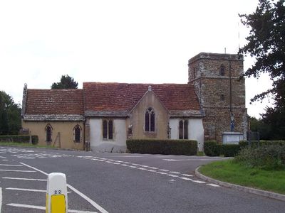
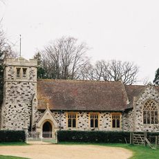
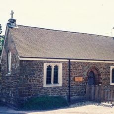
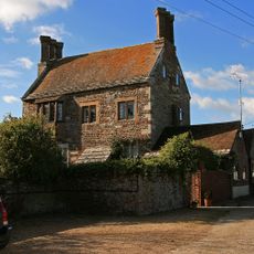
Church of St Hubert, 13th-century parish church in Corfe Mullen, England

St Hubert's Church is a 13th-century stone building in Corfe Mullen with a rectangular layout and a south transept. A church tower was added in the early 14th century and remains a defining feature of the structure.

The building began as a parish church in the 13th century and underwent expansion through the 14th century. Major changes came in 1841, when the north porch was converted into the vestry area.

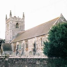
The churchyard holds an ancient yew tree over a thousand years old and a 14th-century cross base, both marks of long Christian worship in this place. These living and stone elements speak to generations who prayed and buried their dead here.

The church sits on elevated ground south of the River Stour, making it visible from a distance. The churchyard and building are generally accessible for visitors to view the exterior at any time.

The building was constructed using local heathstone, a material chosen specifically for the dry ground conditions at this site. This selection of building materials shows how craftspeople adapted their construction to local surroundings.

The community of curious travelers

AroundUs brings together thousands of curated places, local tips, and hidden gems, enriched daily by 60,000 contributors worldwide.

Start exploring
Location
GPS coordinates
50.78470,-2.03442
Latest update
December 14, 2025 15:00
Around this place
Kingston Lacy
United Kingdom

Kingston Lacy

2.9 km
Philae obelisk
United Kingdom

Philae obelisk

2.8 km
Wimborne Model Town
United Kingdom

Wimborne Model Town

3.4 km
Merley House
United Kingdom

Merley House

3.2 km
St Stephen's Church, Pamphill
United Kingdom

St Stephen's Church, Pamphill

2.9 km
Corfe Barrows Nature Park
United Kingdom

Corfe Barrows Nature Park

2.4 km
The Vine, Pamphill
United Kingdom

The Vine, Pamphill

2.7 km
Church of St Mary the Virgin
United Kingdom

Church of St Mary the Virgin

3.3 km
176-188, Church Street
United Kingdom

176-188, Church Street

3.2 km
Chapel Of St Margaret And St Anthony
United Kingdom

Chapel Of St Margaret And St Anthony

3.4 km
White Mill Bridge
United Kingdom

White Mill Bridge

2.9 km
Julian's Bridge
United Kingdom

Julian's Bridge

3.1 km
Pamphill Manor House
United Kingdom

Pamphill Manor House

2.6 km
Footbridge Over The River Winterbourne, 200 Metres West Of King Street
United Kingdom

Footbridge Over The River Winterbourne, 200 Metres West Of King Street

3.6 km
Churchyard Wall
United Kingdom

Churchyard Wall

3.3 km
Poplar Farm Including Attached Barn To North
United Kingdom

Poplar Farm Including Attached Barn To North

2 km
Stable Block To West Of Dean's Court
United Kingdom

Stable Block To West Of Dean's Court

3.6 km
Garden Wall 20 M South Of Kingston Lacy House
United Kingdom

Garden Wall 20 M South Of Kingston Lacy House

2.9 km
Sarcophagus 15 M South Of The Stables At Kingston Lacy House
United Kingdom

Sarcophagus 15 M South Of The Stables At Kingston Lacy House

2.8 km
Barn Opposite White Mill
United Kingdom

Barn Opposite White Mill

2.9 km
Garden Wall To North-West Of Dean's Court
United Kingdom

Garden Wall To North-West Of Dean's Court

3.5 km
Court House
United Kingdom

Court House

247 m
Two Corinthian Capitals Approximately 60 M South Of Kingston Lacy House
United Kingdom

Two Corinthian Capitals Approximately 60 M South Of Kingston Lacy House

2.9 km
Milestone, opp. Little Chef and Petrol station
United Kingdom

Milestone, opp. Little Chef and Petrol station

1.7 km
Milestone, Blandford Road, Corfe Mullen
United Kingdom

Milestone, Blandford Road, Corfe Mullen

1.2 km
Milestone, grass area opp. St Huberts church
United Kingdom

Milestone, grass area opp. St Huberts church

71 m
Milestone, Blandford Road, 160m N of cross-roads with Station Rd, in front of Burton Lux
United Kingdom

Milestone, Blandford Road, 160m N of cross-roads with Station Rd, in front of Burton Lux

3.3 km
Milestone, 50m W of 'Coventry Arms' Pub, outside most westerly house in village
United Kingdom

Milestone, 50m W of 'Coventry Arms' Pub, outside most westerly house in village

383 m
Show the full map
Reviews
Share your experience

No review yet

Discussions
Start a discussion...

No discussion yet

« Church of St Hubert - 13th-century parish church in Corfe Mullen, England » is provided by Around Us (aroundus.com). Images and texts are derived from Wikimedia project under a Creative Commons license. You are allowed to copy, distribute, and modify copies of this page, under the conditions set by the license, as long as this note is clearly visible.

Discover hidden gems everywhere you go!

From secret cafés to breathtaking viewpoints, skip the crowded tourist spots and find places that match your style. Our app makes it easy with voice search, smart filtering, route optimization, and insider tips from travelers worldwide. Download now for the complete mobile experience.

Around Us App Screenshot

A unique approach to discovering new places

Le Figaro

All the places worth exploring

France Info

A tailor-made excursion in just a few clicks

20 Minutes

Around Us
Travel Guide & Maps
Download

Send to your phone

QR Code
1

Open the camera app on your mobile.

2

Point at the QR code with your camera. A notification will appear.

3

Tap the notification to open the link.