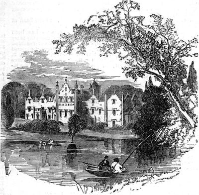
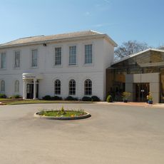
Gilston Park 400 Metres Along Drive West South West From Cumber Land Lodge, Grade II* listed country house in Gilston, England.
Gilston Park is an English country house built around 1852 that extends over approximately 400 meters along a private drive from Cumberland Lodge. The building displays typical Victorian architectural features with solid stone construction and detailed stonework.
Architect Philip Hardwick designed the building in 1852 for landowner John Hodgson using the popular Victorian architectural styles of the period. The estate became one of the notable country house projects of that era and gained recognition under national heritage protection.
The estate is protected as a historic building and displays characteristic features of Victorian country house design with carefully crafted details and stone construction visible today. The exterior and grounds convey a sense of the wealth and status of 19th-century landowners.
The estate is private but can be admired from the access road, where the stone architecture is clearly visible from the street. Details about its history and architectural design are available through the national heritage listing records.
Illustrations of the estate appeared in the Illustrated London News in 1851 before construction was fully complete. This early media attention reflects the strong public interest in this ambitious building project and Hardwick's reputation during that period.
The community of curious travelers
AroundUs brings together thousands of curated places, local tips, and hidden gems, enriched daily by 60,000 contributors worldwide.