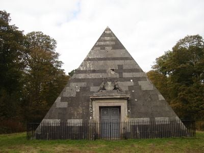
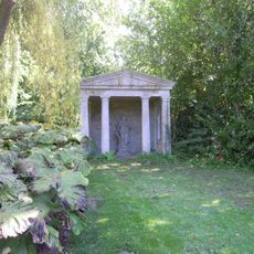
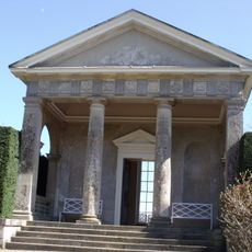
The Mausoleum, Neoclassical mausoleum in Blickling Park, England
The mausoleum is a neoclassical stone structure built on a square base with a central entrance and decorative carvings across its surfaces. Inside, eight wall recesses hold marble sarcophagi and memorial plaques arranged in a single chamber.
Architect Joseph Bonomi designed this structure between 1794 and 1796 as a burial place for John Hobart, the second Earl of Buckinghamshire. Its construction reflected changing burial practices among the English nobility during the late 18th century.
The mausoleum displays the Hobart family crest and heraldic symbols that connect to Anne Boleyn's presence at Blickling. These carved emblems reflect the family's importance to the estate's story.
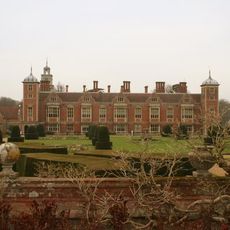
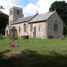
The National Trust manages this protected historic structure located within Blickling Park grounds. The exterior can be viewed from the grounds, though internal access may be restricted during certain times.
The structure was built from thousands of Portland stone blocks that have gradually changed color from light grey to various darker shades over centuries. This slow transformation reveals how stone ages under English weather.
Location: Blickling
GPS coordinates: 52.81920,1.21339
Latest update: December 8, 2025 19:52
Blickling Hall
1.5 km
Wolterton Hall
2.4 km
Church of St Lawrence
2.6 km
Church of St Margaret
2.7 km
Church of St Margaret
2.6 km
Church of St Peter and St Paul
3.1 km
Church of St Andrew
1.6 km
Church of St Mary
2.6 km
Temple In Garden Of Mannington Hall Circa 50 Metres South Of South East Corner Of Moat
3.3 km
Congregational Chapel
2.5 km
Pair Of Urns To North And South Of The Doric Temple
1.9 km
Saracen's Head
2.9 km
Buckinghamshire Arms Public House
1.4 km
Draw Bridge At Mannington Hall
3.4 km
Itteringham War Memorial
2.6 km
Service Range To South East Of Blickling Hall
1.5 km
The Doric Temple
1.9 km
The Tower House
850 m
Milestone On North Side Of B1354
1 km
Fountain, Approximately 50 Metres East Of Blickling Hall
1.5 km
The Orangery
1.8 km
Milestone On North Side Of B1354 Approx 280M West Of Flashpit Farmhouse
2.1 km
Manor Farm House And Attached Garden Walls
2.4 km
The Old Hall
3 km
RAF Oulton Memorial
2.1 km
Milestone, between Wolterton Hall and church ruins
2.5 km
Milepost, Norwich Road, opp. No. 74
2.6 km
Milestone, by Keepers Cottage
2.2 kmVisited this place? Tap the stars to rate it and share your experience / photos with the community! Try now! You can cancel it anytime.
Discover hidden gems everywhere you go!
From secret cafés to breathtaking viewpoints, skip the crowded tourist spots and find places that match your style. Our app makes it easy with voice search, smart filtering, route optimization, and insider tips from travelers worldwide. Download now for the complete mobile experience.
A unique approach to discovering new places❞
— Le Figaro
All the places worth exploring❞
— France Info
A tailor-made excursion in just a few clicks❞
— 20 Minutes