Multi-period site in Micheldever Wood, Archaeological site in Micheldever Wood, Hampshire, Great Britain.
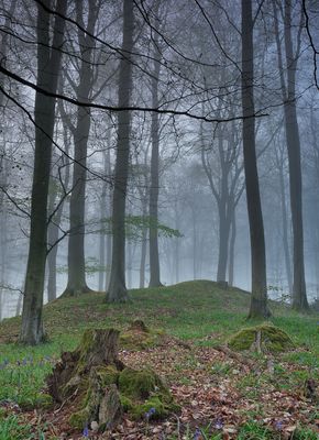
The multi-period site in Micheldever Wood is an archaeological location within a forest containing finds from different eras buried beneath the woodland canopy. The area holds earthen banks, stone heaps, and ground features that provide evidence of past settlement and economic activity.
The site was used by people across multiple epochs, as shown by archaeological excavations revealing different layers of occupation. It received protected status as a scheduled monument to preserve its varied remains for future generations.
The site shows how people lived and worked alongside the forest across different periods, visible in earthen banks, heaps of stones, and remnants of old crafts. These layers of human activity remain visible in the ground today and tell stories of diverse livelihoods.
The site is accessible via marked paths that guide visitors safely through the woodland. It is important to stay on these marked routes and respect the area to protect both the archaeological remains and the natural surroundings.
The location illustrates how challenging it is to protect and study archaeological treasures beneath a dense forest canopy. The combination of growing woodland and ancient remains makes it a special case of preserving history within nature.
The community of curious travelers
AroundUs brings together thousands of curated places, local tips, and hidden gems, enriched daily by 60,000 contributors worldwide.