Ash Hole Cavern

Log in to your account

AroundUs is a community-driven map of interesting places, built by curious explorers like you. It grows with every review, story, and photo you share.
Connect to save your favorite spots, contribute locations, and create personalized routes.
By continuing, you accept our Terms and Conditions and our Privacy Policy

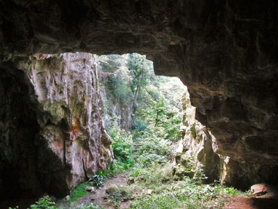
Ash Hole Cavern, Ancient limestone cave in Brixham, England.

The cave system features two entrances: a natural opening at the base of a sinkhole and a wider entrance created through quarrying activities in the 1800s.

Archaeological excavations in the 1830s revealed human remains, Roman coins from emperors Claudius and Nero, and pottery fragments dating back to the Bronze Age.

The cave contains wall inscriptions from the 1920s and holds archaeological materials now displayed at the Brixham Museum for public education.

Visitors can reach the cave entrance by following Mount Pleasant Road in Brixham, with additional information available at the local tourist center.

Reverend Henry Francis Lyte, composer of the hymn 'Abide With Me', conducted investigations searching for a supposed four-mile tunnel to Kingswear.

Location: Brixham

GPS coordinates: 50.40040,-3.49706

Latest update: March 31, 2025 11:41

Around this place
Show the full map
British Seaman’s Boys' Home
United Kingdom

British Seaman’s Boys' Home

770 m
Berry Head House
United Kingdom

Berry Head House

174 m
Brixham Breakwater
United Kingdom

Brixham Breakwater

838 m
Ranscombe House Hotel
United Kingdom

Ranscombe House Hotel

866 m
12, 14 And 16, Ranscombe Road
United Kingdom

12, 14 And 16, Ranscombe Road

910 m
Nos 18 And 20 Including Gate Piers On Street
United Kingdom

Nos 18 And 20 Including Gate Piers On Street

902 m
Brixham War Memorial
United Kingdom

Brixham War Memorial

696 m
Gateway To Wolborough House
United Kingdom

Gateway To Wolborough House

474 m
Ramparts, Counterscarp Revetment, Glacis, Musketry Wall Of Southern Fort
United Kingdom

Ramparts, Counterscarp Revetment, Glacis, Musketry Wall Of Southern Fort

699 m
Ranscombe Court (Terrace) Including Wall Along Ranscombe Road
United Kingdom

Ranscombe Court (Terrace) Including Wall Along Ranscombe Road

917 m
No 12 Including Front Area Wall And Railing
United Kingdom

No 12 Including Front Area Wall And Railing

171 m
Board Of Ordnance Boundary Stone No. 1 At Sx 9400 5595
United Kingdom

Board Of Ordnance Boundary Stone No. 1 At Sx 9400 5595

794 m
Nos 14-32 Including Front Garden Walls And Railings
United Kingdom

Nos 14-32 Including Front Garden Walls And Railings

106 m
Ruined Magazine And Blast Wall 1.8 Metres West Of Guardhouse, Southern Fort
United Kingdom

Ruined Magazine And Blast Wall 1.8 Metres West Of Guardhouse, Southern Fort

682 m
Board Of Ordnance Boundary Stone No 3 At Sx 9400 5615
United Kingdom

Board Of Ordnance Boundary Stone No 3 At Sx 9400 5615

614 m
Sentry Box In Northern Fort, Approximately 3 Metres North Of Hm Coastguard Lookout
United Kingdom

Sentry Box In Northern Fort, Approximately 3 Metres North Of Hm Coastguard Lookout

927 m
1, 2 And 3, Heath Road
United Kingdom

1, 2 And 3, Heath Road

901 m
Wolborough House
United Kingdom

Wolborough House

424 m
Hardy's Head Battery At Sx 9440 5675
United Kingdom

Hardy's Head Battery At Sx 9440 5675

352 m
Hm Coastguard Lookout In Northern Fort Including Perimeter Wall
United Kingdom

Hm Coastguard Lookout In Northern Fort Including Perimeter Wall

926 m
Napoleonic Fort Guardhouse, Approximately 30 Metres Inside Entrance To Northern Fort
United Kingdom

Napoleonic Fort Guardhouse, Approximately 30 Metres Inside Entrance To Northern Fort

657 m
Hm Coastguard Rescue Station Including Walls, Piers, Railings At Front Approach
United Kingdom

Hm Coastguard Rescue Station Including Walls, Piers, Railings At Front Approach

68 m
Slipway And Hard, Brixham Outer Harbour
United Kingdom

Slipway And Hard, Brixham Outer Harbour

587 m
Former Artillery Store Approximately 12 Metres West Of Coastguard Lookout In Northern Fort
United Kingdom

Former Artillery Store Approximately 12 Metres West Of Coastguard Lookout In Northern Fort

903 m
Nos 39-49 Including Front Garden Walls And Railings
United Kingdom

Nos 39-49 Including Front Garden Walls And Railings

921 m
The Old Redoubt and later Victorian Rifle Range Target, 540m south west of Berry Head Fort
United Kingdom

The Old Redoubt and later Victorian Rifle Range Target, 540m south west of Berry Head Fort

715 m
Berry Head Fort and battery and Hardy's Head Battery
United Kingdom

Berry Head Fort and battery and Hardy's Head Battery

788 m
Ramparts, Revetments, North Battery Platform, North And South Musketry Walls Of Northern Fort
United Kingdom

Ramparts, Revetments, North Battery Platform, North And South Musketry Walls Of Northern Fort

602 m
Show the full map

Reviews

Visited this place? Tap the stars to rate it and share your experience / photos with the community! Try now! You can cancel it anytime.

« Ash Hole Cavern - Ancient limestone cave in Brixham, England. » is provided by Around Us (aroundus.com). Images and texts are derived from Wikimedia project under a Creative Commons license. You are allowed to copy, distribute, and modify copies of this page, under the conditions set by the license, as long as this note is clearly visible.

Discover hidden gems everywhere you go!

From secret cafés to breathtaking viewpoints, skip the crowded tourist spots and find places that match your style. Our app makes it easy with voice search, smart filtering, route optimization, and insider tips from travelers worldwide. Download now for the complete mobile experience.

Around Us App Screenshot

A unique approach to discovering new places

Le Figaro

All the places worth exploring

France Info

A tailor-made excursion in just a few clicks

20 Minutes