Kingholm Quay

Log in to your account

AroundUs is a community-driven map of interesting places, built by curious explorers like you. It grows with every review, story, and photo you share.
Connect to save your favorite spots, contribute locations, and create personalized routes.
By continuing, you accept our Terms and Conditions and our Privacy Policy
Add to collection
Map
Suggest a change
Share

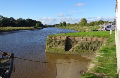
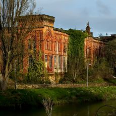
Kingholm Quay, Category B listed building at River Nith, Dumfries and Galloway, Scotland.

Kingholm Quay is a listed harbor structure on the eastern bank of the River Nith, featuring red-brick storage sheds and granite construction. A floating pontoon and slipway provide access to the water, making the site functional for small watercraft.

The site was originally known as Comyn's Holm before being renamed following Robert the Bruce's actions in 1306. The location subsequently became a gift to the Burgesses of Dumfries and eventually developed into a working harbor.

The site once served as a hub for local textile production, where workers created specialized fabrics for trousers and traditional Scottish patterns. This industrial past shaped the character of the place and remains visible in its buildings and structures today.

Visit during high tide to see the basin fully filled with water and the entire structure properly displayed. The site is openly accessible from the waterfront, offering clear views of the harbor layout from the elevated bank.

The harbor basin incorporates repurposed iron cannons as mooring posts, a practical remnant from earlier military times. A Victorian-era scouring system uses the natural flow of Kingholm Burn to flush out silt and keep the channel navigable.

Location: Dumfries and Galloway

Location: Dumfries

GPS coordinates: 55.04600,-3.60618

Latest update: December 13, 2025 12:23

Photos
Around this place
Dumfries Museum
United Kingdom

Dumfries Museum

2.2 km
Dumfries, 24 Burns Street, Robert Burns House
United Kingdom

Dumfries, 24 Burns Street, Robert Burns House

2.2 km
St Michael's Church, Dumfries
United Kingdom

St Michael's Church, Dumfries

2.1 km
Dumfries, Bankend Road, Crichton Royal Hospital, Crichton Memorial Church
United Kingdom

Dumfries, Bankend Road, Crichton Royal Hospital, Crichton Memorial Church

940 m
Dumfries, 29 Irish Street, Dumfries Youth Club
United Kingdom

Dumfries, 29 Irish Street, Dumfries Youth Club

2.3 km
Dumfries, Troqueer Road, Troqueer Parish Church
United Kingdom

Dumfries, Troqueer Road, Troqueer Parish Church

1.5 km
Dumfries, Church Street, Sinclair Memorial
United Kingdom

Dumfries, Church Street, Sinclair Memorial

2.2 km
Burns Mausoleum
United Kingdom

Burns Mausoleum

2.1 km
Dumfries, Suspension Bridge
United Kingdom

Dumfries, Suspension Bridge

2.1 km
Dumfries, Troqueer Road, Rosefield Mills
United Kingdom

Dumfries, Troqueer Road, Rosefield Mills

1.9 km
Dumfries, Dock Park, Bandstand
United Kingdom

Dumfries, Dock Park, Bandstand

1.8 km
Dumfries, Bankend Road, Crichton Royal Hospital, Easterbrook Hall
United Kingdom

Dumfries, Bankend Road, Crichton Royal Hospital, Easterbrook Hall

1.1 km
Dumfries, Glencaple Road, Castledykes View, Garden Walls; Gate Piers
United Kingdom

Dumfries, Glencaple Road, Castledykes View, Garden Walls; Gate Piers

1.3 km
Cast Iron Bench 5 Of 9
United Kingdom

Cast Iron Bench 5 Of 9

1.7 km
Cast Iron Bench 2 Of 9
United Kingdom

Cast Iron Bench 2 Of 9

1.9 km
Dumfries, Church Street, Burgh Museum And Observatory
United Kingdom

Dumfries, Church Street, Burgh Museum And Observatory

2.2 km
Cast Iron Bench 9 Of 9
United Kingdom

Cast Iron Bench 9 Of 9

1.7 km
Cast Iron Bench 3 Of 9
United Kingdom

Cast Iron Bench 3 Of 9

1.8 km
St Michael's Bridge
United Kingdom

St Michael's Bridge

2 km
Cast Iron Bench 8 Of 9
United Kingdom

Cast Iron Bench 8 Of 9

1.5 km
Dumfries, Bankend Road, Crichton Royal Hospital, Johnston House
United Kingdom

Dumfries, Bankend Road, Crichton Royal Hospital, Johnston House

1.1 km
Dumfries, St Michael Street, St Michael's Churchyard, Main Gate
United Kingdom

Dumfries, St Michael Street, St Michael's Churchyard, Main Gate

2.1 km
Cast Iron Bench 1 Of 9
United Kingdom

Cast Iron Bench 1 Of 9

1.9 km
Cast Iron Bench 4 Of 9
United Kingdom

Cast Iron Bench 4 Of 9

1.6 km
Cast Iron Bench 7 Of 9
United Kingdom

Cast Iron Bench 7 Of 9

1.6 km
Kirkpatrick Macmillan footbridge
United Kingdom

Kirkpatrick Macmillan footbridge

1.3 km
Dumfries, New Abbey Road, Maxwelltown War Memorial
United Kingdom

Dumfries, New Abbey Road, Maxwelltown War Memorial

2.1 km
Cast Iron Bench 6 Of 9
United Kingdom

Cast Iron Bench 6 Of 9

1.6 km
Show the full map
Reviews

Visited this place? Tap the stars to rate it and share your experience / photos with the community! Try now! You can cancel it anytime.

« Kingholm Quay - Category B listed building at River Nith, Dumfries and Galloway, Scotland » is provided by Around Us (aroundus.com). Images and texts are derived from Wikimedia project under a Creative Commons license. You are allowed to copy, distribute, and modify copies of this page, under the conditions set by the license, as long as this note is clearly visible.

Discover hidden gems everywhere you go!

From secret cafés to breathtaking viewpoints, skip the crowded tourist spots and find places that match your style. Our app makes it easy with voice search, smart filtering, route optimization, and insider tips from travelers worldwide. Download now for the complete mobile experience.

Around Us App Screenshot

A unique approach to discovering new places

Le Figaro

All the places worth exploring

France Info

A tailor-made excursion in just a few clicks

20 Minutes