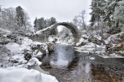
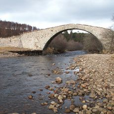
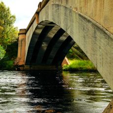
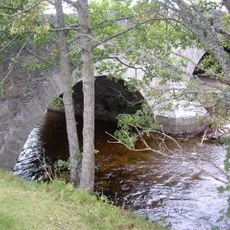
Carrbridge Packhorse Bridge, Stone packhorse bridge in Carrbridge, Scotland.
Carrbridge Packhorse Bridge is a single-span stone arch crossing the River Dulnain, built with roughly finished rubble stone. The narrow, high arch allowed packhorses to pass while giving floodwater room to flow underneath without obstruction.
Brigadier-General Alexander Grant commissioned this crossing in 1717, having the stonemason John Niccelsone build it to serve travelers and traders. The bridge lost its protective railings during severe floods in 1829, leaving only the bare arch structure that still stands today.
Locals call it Coffin Bridge because it allowed funeral processions to reach Duthil Church when water levels rose too high for other routes. The name reflects how the crossing served an essential role in the community's spiritual practices.
You can walk around the bridge to see it from several angles, and there are viewing spots on both banks of the river. Parking is available right beside the B9153 road, making it easy to stop and explore.
Severe floods in 1829 swept away the original railings, leaving only the bare stone arch exposed above the water. This accident gave the bridge its distinctive stripped-down appearance that has been preserved ever since.
Location: Highland
Location: Duthil and Rothiemurchus
Inception: 1717
GPS coordinates: 57.28383,-3.81583
Latest update: December 8, 2025 19:53
Strathspey Railway
5.4 km
Landmark Forest Adventure Park
627 m
Landmark Forest Adventure Park
702 m
Loch Garten
8.8 km
Craigellachie National Nature Reserve
10.7 km
Tomatin, Railway Viaduct Over River Findhorn
11.5 km
Duthil, Old Parish Church And Churchyard
3.2 km
Sluggan Bridge
3.8 km
Broomhill Bridge
9.1 km
Avielochan Chambered Cairn
6.2 km
Granish Cairn
7.4 km
Auchgourish botanical garden
5.5 km
Muckrach Castle
8.2 km
New Spey Bridge
13.3 km
Castle Roy
10 km
Findhorn Bridge
11.3 km
Slochd Viaduct
6 km
Boat Of Garten Station, Footbridge
5.5 km
Tomatin, Railway Viaduct Over Old A9 Road
12 km
Nethy Bridge
9.7 km
Avielochan
5.7 km
Tom a' Chaisteil
10.7 km
Carrbridge Station, Footbridge
880 m
Aviemore Railway Station, Signal Box
10.2 km
Aviemore, cairn 25m SW of 24 Muirton
9.5 km
Aviemore Station, Island Platform
10.6 km
Boat Of Garten Station, Signal Box
5.6 km
Aviemore stone circle
9.5 kmVisited this place? Tap the stars to rate it and share your experience / photos with the community! Try now! You can cancel it anytime.
Discover hidden gems everywhere you go!
From secret cafés to breathtaking viewpoints, skip the crowded tourist spots and find places that match your style. Our app makes it easy with voice search, smart filtering, route optimization, and insider tips from travelers worldwide. Download now for the complete mobile experience.
A unique approach to discovering new places❞
— Le Figaro
All the places worth exploring❞
— France Info
A tailor-made excursion in just a few clicks❞
— 20 Minutes