·

Enable Location

We need your location to show you interesting places around you

Discover nearby places

Find interesting locations and hidden gems around you

Precise directions

Get accurate directions and distances to places

Your location is never shared with other users. It's only used when you tap the location button.

Knocking Hoe

Log in to your account

Start exploring — it's free

Trusted by 62,650 travelers worldwide

Continue with Google
Continue with Apple
or

We will send you a code to connect

By continuing, you accept our Terms and Conditions and our Privacy Policy

Check your inbox

We've sent a pincode in your inbox. Please enter the code below.

Knocking Hoe, Nature reserve in Bedfordshire, England.

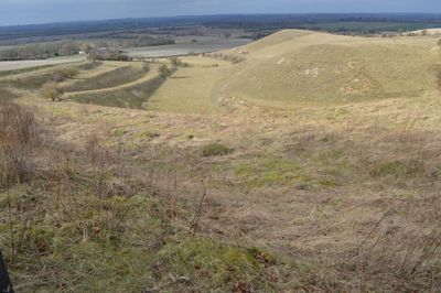
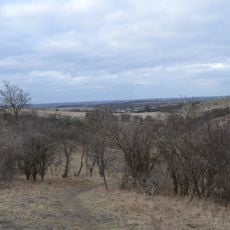
Knocking Hoe is a nature reserve in Bedfordshire featuring steep chalk grassland slopes that support uncommon plants such as moon carrot and field fleawort. The roughly 7.7-hectare site contains diverse microclimates across its valley sides that allow these specialized species to flourish.

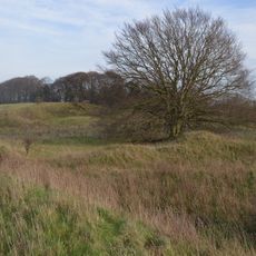
The site displays traces of medieval farming through its strip lynchet field system, which has remained largely unchanged for many centuries. This ancient land management approach inadvertently preserved the chalk grassland habitat that makes the reserve valuable today.

Natural England manages this protected reserve as a safeguard for rare plant communities that thrive in the chalk landscape. The site demonstrates modern conservation efforts to maintain grassland habitats for species that are found nowhere else in the region.

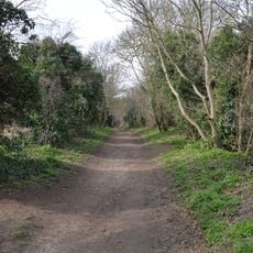
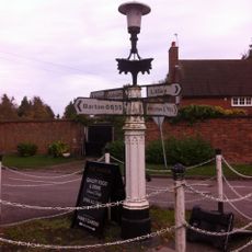
Access to the reserve is via a footpath from Hitchin Road in Pegsdon, with parking available roughly 500 meters south on the B655. Sturdy footwear is recommended since the steep slopes can become slippery, especially after rain.

The autumn lady's tresses orchids found here have been continuously studied for over fifty years, contributing to important botanical research. This long-term scientific work has greatly advanced understanding of the lifecycle of this rare orchid species.

The community of curious travelers

AroundUs brings together thousands of curated places, local tips, and hidden gems, enriched daily by 60,000 contributors worldwide.

Start exploring
Location
GPS coordinates
51.96300,-0.35500
Latest update
December 14, 2025 17:00
Around this place
Hexton Manor
United Kingdom

Hexton Manor

2.3 km
United Kingdom

Oughtonhead Common

3.7 km
Telegraph Hill, Hertfordshire
United Kingdom

Telegraph Hill, Hertfordshire

2.3 km
Oughtonhead Nature Reserve
United Kingdom

Oughtonhead Nature Reserve

3.8 km
Oughtonhead Lane
United Kingdom

Oughtonhead Lane

4.1 km
Deacon Hill
United Kingdom

Deacon Hill

1.4 km
Church of St Faith (Church of England)
United Kingdom

Church of St Faith (Church of England)

2.7 km
Barton Gravel Pit
United Kingdom

Barton Gravel Pit

3.3 km
Church of All Saints
United Kingdom

Church of All Saints

3.4 km
Church of St Mary Magdalene, Offley
United Kingdom

Church of St Mary Magdalene, Offley

4.1 km
Parish Church of Saint Margaret
United Kingdom

Parish Church of Saint Margaret

3.5 km
Church of St Mary (Church of England)
United Kingdom

Church of St Mary (Church of England)

1.9 km
Church of St Peter (C of E) at Corner with Holwell Road
United Kingdom

Church of St Peter (C of E) at Corner with Holwell Road

4.3 km
The Fox Inn
United Kingdom

The Fox Inn

1.9 km
Pirton Methodist Church
United Kingdom

Pirton Methodist Church

1.9 km
42, Church Street
United Kingdom

42, Church Street

3.4 km
14, 14A, 16 And 16A, Church Street
United Kingdom

14, 14A, 16 And 16A, Church Street

3.4 km
The Green Man Public House
United Kingdom

The Green Man Public House

3.7 km
Pirton War Memorial, Hertfordshire
United Kingdom

Pirton War Memorial, Hertfordshire

1.9 km
The Five Bells Public House
United Kingdom

The Five Bells Public House

3.4 km
Walnut Tree Farmhouse
United Kingdom

Walnut Tree Farmhouse

1.9 km
Offley War Memorial
United Kingdom

Offley War Memorial

4.1 km
High Down House With Buildings And Walls Around Courtyard On North Side
United Kingdom

High Down House With Buildings And Walls Around Courtyard On North Side

1.3 km
Montgrove Farmhouse
United Kingdom

Montgrove Farmhouse

3.8 km
Villagers Pump At Junction Of Village Street With Barton Road
United Kingdom

Villagers Pump At Junction Of Village Street With Barton Road

2.5 km
Farmbuildings Fronting Road At Walnut Tree Farm
United Kingdom

Farmbuildings Fronting Road At Walnut Tree Farm

1.9 km
Offley Place (Hertfordshire Educational Department Residential Centre) And Linked North Service Block
United Kingdom

Offley Place (Hertfordshire Educational Department Residential Centre) And Linked North Service Block

3.9 km
Three Gables
United Kingdom

Three Gables

1.7 km
Show the full map
« Knocking Hoe - Nature reserve in Bedfordshire, England » is provided by Around Us (aroundus.com). Images and texts are derived from Wikimedia project under a Creative Commons license. You are allowed to copy, distribute, and modify copies of this page, under the conditions set by the license, as long as this note is clearly visible.

Discover hidden gems everywhere you go!

From secret cafés to breathtaking viewpoints, skip the crowded tourist spots and find places that match your style. Our app makes it easy with voice search, smart filtering, route optimization, and insider tips from travelers worldwide. Download now for the complete mobile experience.

Around Us App Screenshot

A unique approach to discovering new places

Le Figaro

All the places worth exploring

France Info

A tailor-made excursion in just a few clicks

20 Minutes

Around Us
Travel Guide & Maps
Download

Send to your phone

QR Code
1

Open the camera app on your mobile.

2

Point at the QR code with your camera. A notification will appear.

3

Tap the notification to open the link.