Weston Turville Reservoir

Log in to your account

AroundUs is a community-driven map of interesting places, built by curious explorers like you. It grows with every review, story, and photo you share.
Connect to save your favorite spots, contribute locations, and create personalized routes.
By continuing, you accept our Terms and Conditions and our Privacy Policy
Add to collection
Map
Suggest a change
Share

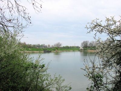
Weston Turville Reservoir, Protected reservoir in Weston Turville, England.

The 20-hectare water body features marshy fen, extensive reedbeds, and small woods that provide habitats for numerous waterfowl species throughout the year.

The reservoir was built in 1797 to supply water to a section of the Grand Union Canal, contributing to the regional transportation infrastructure.

The Aylesbury Sailing Club maintains an active presence at the reservoir, offering water activities and community engagement opportunities for local residents.

Visitors can access free parking in a dedicated lay-by on World's End Lane, with the nearest facilities available at the nearby garden center.

Reed warblers establish colonies at the site, building their nests among reed stems while water rails breed in the surrounding vegetation.

Location: Weston Turville

Elevation above the sea: 107 m

GPS coordinates: 51.77890,-0.75120

Latest update: March 2, 2025 23:11

Around this place
Show the full map
Halton House
United Kingdom

Halton House

1.7 km
Aston Clinton House
United Kingdom

Aston Clinton House

3 km
Wendover Woods
United Kingdom

Wendover Woods

2.8 km
Aston Clinton Ragpits
United Kingdom

Aston Clinton Ragpits

2.9 km
Bacombe and Coombe Hills
United Kingdom

Bacombe and Coombe Hills

3 km
St Michael and All Angels Church, Aston Clinton
United Kingdom

St Michael and All Angels Church, Aston Clinton

2.8 km
Church of St Michael and All Angels
United Kingdom

Church of St Michael and All Angels

1.3 km
Church of St Mary the Virgin, Weston Turville
United Kingdom

Church of St Mary the Virgin, Weston Turville

716 m
Parish Church of St Mary
United Kingdom

Parish Church of St Mary

2.5 km
Church of St Mary
United Kingdom

Church of St Mary

2.9 km
Bridge Over Canal In Grounds Of Halton House
United Kingdom

Bridge Over Canal In Grounds Of Halton House

1.3 km
Red Lion Hotel
United Kingdom

Red Lion Hotel

1.9 km
Wendover Clock Tower
United Kingdom

Wendover Clock Tower

1.9 km
Coombe Hill Monument
United Kingdom

Coombe Hill Monument

3.2 km
Yew Tree Cottage
United Kingdom

Yew Tree Cottage

3.7 km
The Pack Horse Public House
United Kingdom

The Pack Horse Public House

1.9 km
Dancersend Nature Reserve
United Kingdom

Dancersend Nature Reserve

3.5 km
Lychgate and Churchyard Wall to St Mary's Church
United Kingdom

Lychgate and Churchyard Wall to St Mary's Church

2.4 km
Boddington Camp: a slight univallate hillfort on the summit of Boddington Hill
United Kingdom

Boddington Camp: a slight univallate hillfort on the summit of Boddington Hill

2.6 km
Bank Farmhouse
United Kingdom

Bank Farmhouse

1.9 km
Milestone, Wendover Road; by No. 154, just N of A413 / A4010 roundabout
United Kingdom

Milestone, Wendover Road; by No. 154, just N of A413 / A4010 roundabout

2.3 km
The Red House
United Kingdom

The Red House

1.8 km
Barn To North Of Smalldeam Farmhouse
United Kingdom

Barn To North Of Smalldeam Farmhouse

3.5 km
Milestone, South Street; nr turn to Church Lane for St Mary the Virgin Church
United Kingdom

Milestone, South Street; nr turn to Church Lane for St Mary the Virgin Church

2.4 km
Milestone, Aylesbury Road; outside Recreation Ground
United Kingdom

Milestone, Aylesbury Road; outside Recreation Ground

911 m
Milestone, Risborough Road; 400m S of Terrick House Roundabout, nr Manor Mead
United Kingdom

Milestone, Risborough Road; 400m S of Terrick House Roundabout, nr Manor Mead

3.4 km
Milestone, Risborough Road; North Lee, near North Lee Farm
United Kingdom

Milestone, Risborough Road; North Lee, near North Lee Farm

2.7 km
Milestone, Station Road; outside No. 16
United Kingdom

Milestone, Station Road; outside No. 16

2.8 km
Show the full map

Reviews

Visited this place? Tap the stars to rate it and share your experience / photos with the community! Try now! You can cancel it anytime.

« Weston Turville Reservoir - Protected reservoir in Weston Turville, England » is provided by Around Us (aroundus.com). Images and texts are derived from Wikimedia project under a Creative Commons license. You are allowed to copy, distribute, and modify copies of this page, under the conditions set by the license, as long as this note is clearly visible.

Discover hidden gems everywhere you go!

From secret cafés to breathtaking viewpoints, skip the crowded tourist spots and find places that match your style. Our app makes it easy with voice search, smart filtering, route optimization, and insider tips from travelers worldwide. Download now for the complete mobile experience.

Around Us App Screenshot

A unique approach to discovering new places

Le Figaro

All the places worth exploring

France Info

A tailor-made excursion in just a few clicks

20 Minutes