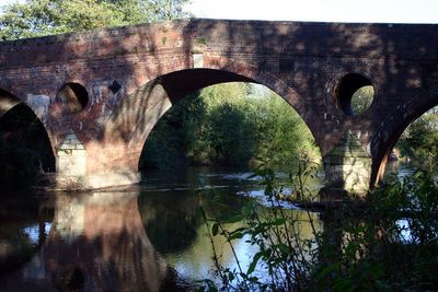
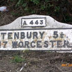
Eastham Bridge, Historic road bridge in Lindridge, England
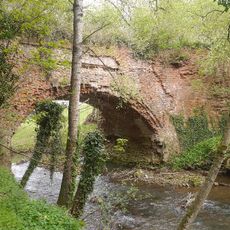
Eastham Bridge is a road crossing over the River Teme in Lindridge, originally built from brick and sandstone with three elliptical arches. The central opening spans wider than the two side passages.
The structure was built in 1793 as a toll crossing and kept that role until 1907, when Worcestershire County Council took ownership. Following its collapse in May 2016, it was rebuilt with a new steel structure that reopened in April 2017.
The bridge received Grade II listed status in October 1952, recognizing its architectural and engineering value within the national heritage protection framework of England.
The location is accessible by vehicle since the bridge is part of the main road allowing regular traffic. Visitors should be aware of active traffic on this road when exploring the structure and surrounding pathways.
The bridge displays a distinctive pattern of red and blue brickwork with circular flood outlets and pyramid-shaped tops on its square piers. These details make it recognizable and reveal the craftsmanship in its original construction.
Location: Eastham
Inception: 1793
Made from material: brick
GPS coordinates: 52.31864,-2.50139
Latest update: December 14, 2025 16:46
Sodington Hall
3.9 km
Church of St John the Baptist, Mamble
3.9 km
Church of St Michael and All Angels
4 km
Church of St Peter and St Paul
404 m
Church of All Saints
3.2 km
Church of St Michael
2.7 km
Church of All Saints
3.4 km
Church of St Michael
3 km
Church of St Lawrence
1.6 km
The Fox Inn
4 km
The Sun And Slipper Public House
3.9 km
Rea Aqueduct At Ngr So 6511 7030 (That Part In Neen Sollars Cp)
1.5 km
Shakenhurst
4.1 km
Lower Langley Farmhouse
4.1 km
Church Farmhouse
3 km
Milepost, Rochford Mount
2.9 km
Milestone, roadside at SO6544569565
689 m
Milestone, Linkhill Wood, S of "The Farm"
2.8 km
Milestone, W of Eastham Bridge
396 m
Milestone, E of Hill Top
2.7 km
Milestone, Lodge Farm, 300m E of "Fox Inn"
4.1 km
Milestone, 100m W of Station Nursery
1.9 km
Milestone, Aston Bank turn
3.2 km
Milestone, opp. drive to Woodston Farm
1.2 km
Milestone, W of Wood Park, by 30 mph sign entering Rochford from Tenbury
3.8 km
Milestone, Rochford Mount
2.9 km
Milestone, Broombank, on line of old road
1.4 km
Milestone, Hurcott, W of car park of "Tally Ho!" PH
3.6 kmVisited this place? Tap the stars to rate it and share your experience / photos with the community! Try now! You can cancel it anytime.
Discover hidden gems everywhere you go!
From secret cafés to breathtaking viewpoints, skip the crowded tourist spots and find places that match your style. Our app makes it easy with voice search, smart filtering, route optimization, and insider tips from travelers worldwide. Download now for the complete mobile experience.
A unique approach to discovering new places❞
— Le Figaro
All the places worth exploring❞
— France Info
A tailor-made excursion in just a few clicks❞
— 20 Minutes