Cudden Point, Coastal headland in St Hilary, United Kingdom
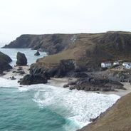
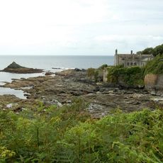
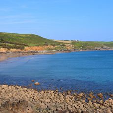
Cudden Point is a headland that extends into Mount's Bay along Cornwall's southern coast, marked by steep cliffs that drop sharply to the sea. The rocky outcrop forms a distinctive feature visible from both land and water.
The headland was recorded on maritime charts as early as 1813, serving as a critical reference point for ships navigating into Mount's Bay. Its long history as a navigation marker reflects the importance of this coastal feature to maritime traffic.
Local fishing communities have long relied on this headland as a navigation marker to guide their boats safely and identify productive waters.
The site is best reached by following marked walking paths from St Hilary village that lead directly to the headland. The open vantage points offer clear views across the coastline and bay without obstruction.
The cliffs host populations of Cuscuta epithymum, a parasitic plant species that relies on other plants for survival in this coastal environment. This unusual plant life makes the site botanically interesting for attentive visitors.
Location: St Hilary
GPS coordinates: 50.09921,-5.42695
Latest update: December 6, 2025 19:06
Cornwall holds scattered coves, historic manors, and ancient stone circles that together create a collection of places reflecting the region's history, culture, and landscape. Visitors can discover medieval castles like Tintagel Castle, climb lighthouses, explore underground caves, and walk through...
Pengersick Castle
3.2 km
Acton Castle
707 m
Chymorvah House
3.7 km
Church of Saint Germoe
3.9 km
The Church of St Piran and St Michael
2.2 km
Crown Inn
3 km
Milestone At Sw 545300
2.3 km
Trevenner Farmhouse And Trevenner Cottage
3.9 km
Gazebo At Sw 52023048
4.1 km
Cross At Approximately 13 Metres South Of Porch Of Church Of Saint Hilary
3.5 km
Porth-en-alls Lodge
822 m
Milestone At Sw 530305
3.4 km
Perranuthnoe War Memorial
2.2 km
Gate Piers And Flanking Walls, West Of Spindrift House
4.1 km
1-3, Turnpike Road
3.9 km
Milestone At Sw561294
2 km
Netherleigh Including Wall And Railings At The Front (North)
4.1 km
Tregurtha Downs mine complex
3.6 km
Lower-An-Gothaw
3.9 km
Cross At 4 Metres South Of Porch Of Church Of Saint Hilary
3.5 km
Spindrift House
4.1 km
Lunn-Aire And Adjoining House
4.1 km
Milestone At Sw576292
2.9 km
Hen-A-Noweth
4.1 km
Porth-en-alls
840 m
Chimney At Sw53753114
3.7 km
St Germoe's Chair
3.9 km
Perranuthnoe Beach
1.8 kmVisited this place? Tap the stars to rate it and share your experience / photos with the community! Try now! You can cancel it anytime.
Discover hidden gems everywhere you go!
From secret cafés to breathtaking viewpoints, skip the crowded tourist spots and find places that match your style. Our app makes it easy with voice search, smart filtering, route optimization, and insider tips from travelers worldwide. Download now for the complete mobile experience.
A unique approach to discovering new places❞
— Le Figaro
All the places worth exploring❞
— France Info
A tailor-made excursion in just a few clicks❞
— 20 Minutes