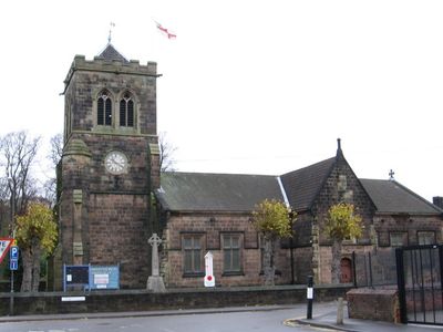
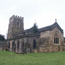
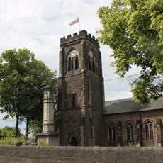
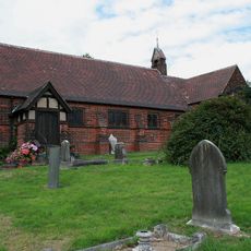
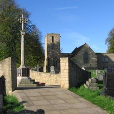
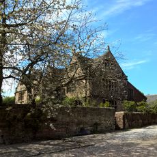
Christ Church, Grade II listed church in Ironville, United Kingdom
Christ Church is a Grade II listed building with characteristic Gothic features including pointed arches, tall spires, and fine stonework. The structure from the 19th century displays typical Victorian ecclesiastical design of its period.
Henry Isaac Stevens built the structure in 1852 during Derbyshire's industrial expansion, when Ironville experienced rapid growth. This period saw the creation of many new community institutions designed to serve the expanding population.
The church has long served as a gathering place where locals come for worship and community events. It reflects the religious values that held together the working communities of Ironville.
The building remains open to visitors who wish to view the Victorian church design and attend services. Regular religious services take place, offering insight into how the space is actively used by the local community.
The building combines religious requirements with influences from industrial construction methods of its era, creating a rare blend of sacred design and working-class functionality. This mixture shows how churches in industrial towns took on particular roles in their communities.
Location: Ironville
Inception: 1852
Architects: Henry Isaac Stevens
GPS coordinates: 53.06285,-1.35088
Latest update: December 14, 2025 18:40
Midland Railway – Butterley
3.2 km
Codnor Castle
2 km
Carnfield Hall
4.2 km
Butterley Reservoir, Derbyshire
3.5 km
Butterley Hall
3.2 km
St. Helen's Church, Selston
2.6 km
Ripley Town Hall
4 km
All Saints' Church, Ripley
3.9 km
Church of St James
1.1 km
Church of St Matthew
4.7 km
Church of St. Michael and All Angels, Underwood
4 km
St. Mary's Church, Westwood
1.4 km
St James' Church, Codnor
3.6 km
War Memorial and Railings
4.7 km
Church of St Helen
3.5 km
Church of St Andrew
3.4 km
Milepost At Sk 443 562
4.3 km
Jessop Monument
946 m
Codnor Park and Ironville War Memorial
21 m
Jacksdale War Memorial
1 km
Pinxton War Memorial Cross
3.6 km
Alfreton House
4.5 km
House Of Confinement
4.4 km
Signal Box To The North Of Track 480 Metres West Of Butterley Station, And 30 Metres East Of Asher Lane Railway Crossing
3.8 km
Milepost Adjacent To Number 8
4.1 km
Signal Box 30 Metres North East Of Cumberland House At The Midland Railway Trust Station
3.2 km
Stone Row
1.1 km
Padley Hall
4.2 kmVisited this place? Tap the stars to rate it and share your experience / photos with the community! Try now! You can cancel it anytime.
Discover hidden gems everywhere you go!
From secret cafés to breathtaking viewpoints, skip the crowded tourist spots and find places that match your style. Our app makes it easy with voice search, smart filtering, route optimization, and insider tips from travelers worldwide. Download now for the complete mobile experience.
A unique approach to discovering new places❞
— Le Figaro
All the places worth exploring❞
— France Info
A tailor-made excursion in just a few clicks❞
— 20 Minutes