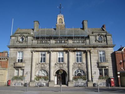
The Municipal Buildings, Grade II listed town hall in Crewe, England
The Municipal Buildings is a town hall in Crewe featuring English Baroque architecture with a symmetrical five-bay facade, Ionic columns, and decorative sandstone carvings throughout. Constructed from sandstone and stone slate, it now functions as a meeting space for Cheshire East Council.
Built between 1902 and 1905 by architect Henry Hare, this structure was completed during Crewe's rapid transformation from a small village into a major railway hub. The timing of its construction reflected the town's growing importance and prosperity at that era.
Carved figures on the facade depict local trades and industries, telling the story of what this community built its prosperity on. The weathervane on top resembles Stephenson's Rocket, reflecting how closely the town's identity ties to its railway history.
The building sits on Earle Street in central Crewe and is easily reached on foot from the town center. As it serves as the official home of Cheshire East Council, hours may vary depending on public events and meetings held there.
A bronze locomotive model crafted by Harry Lightfoot, a railway workshop fitter, sits in the foyer and stands as a remarkable example of worker craftsmanship. This piece captures the industrial skill and pride that characterized daily life in the town.
Location: Crewe
Inception: 1905
Architects: Henry Hare
Architectural style: English Baroque
Made from material: sandstone, stone slate
GPS coordinates: 53.09848,-2.43948
Latest update: December 14, 2025 16:46
Bentley Crewe
2.3 km
Crewe Heritage Centre
440 m
Crewe North Junction signal box
722 m
Lyceum Theatre
69 m
St Michael's Church, Coppenhall
991 m
St Mary's Church, Crewe
495 m
St Barnabas' Church, Crewe
1.6 km
St Michael and All Angels Church, Crewe Green
2.1 km
Christ Church Tower, Crewe
180 m
Union Street Baptist Church, Crewe
745 m
Crewe War Memorial
53 m
Boer War Memorial, Crewe
1.9 km
Clock Tower in Queen's Park
1.9 km
Crewe Heritage Centre
579 m
Christadelphian Hall
380 m
1867 buildings at Crewe Railway Station
1.1 km
Webb Orphanage, now Webb House
2 km
47, Delamere Street
478 m
76–90A, Victoria Street
388 m
1–19, Betley Street
301 m
The Market Hall
34 m
North Lodge to Crewe Hall Park
3 km
West Lodge at Queen's Park
1.9 km
East Lodge at Queen's Park
1.9 km
1–19, Dorfold Street
259 m
Milestone At Corner Of Narrow Lane
2 km
Milepost, Crewe Road; midway between Broughton Lane and Laidon Avenue jcts
2.3 km
Milepost, Crewe Road; N of Waterloo Road jct
3.1 kmVisited this place? Tap the stars to rate it and share your experience / photos with the community! Try now! You can cancel it anytime.
Discover hidden gems everywhere you go!
From secret cafés to breathtaking viewpoints, skip the crowded tourist spots and find places that match your style. Our app makes it easy with voice search, smart filtering, route optimization, and insider tips from travelers worldwide. Download now for the complete mobile experience.
A unique approach to discovering new places❞
— Le Figaro
All the places worth exploring❞
— France Info
A tailor-made excursion in just a few clicks❞
— 20 Minutes