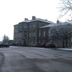
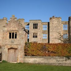
Kiveton Hall, Grade II listed house in Wales, United Kingdom.
Kiveton Hall is a stone-built house in Wales featuring a slate roof and three bays across its front elevation. The structure rises two storeys with an additional attic space above.
The current building replaced an earlier house built between 1698 and 1704 for Thomas Osborne, First Duke of Leeds, which was demolished in 1811. This rebuilding marked a transition for the estate in the early 19th century.
The building displays traditional English architectural elements with multi-pane windows and a curved central bay that shape its character.
The property is accessed through entrance gate piers, and visitors should be aware of regulations protecting Grade II listed buildings. Respect for the historic structure and its boundaries is important when visiting.
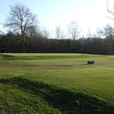
The property includes a ha-ha, a sunken wall that kept livestock away from gardens without interrupting views of the surrounding landscape. This clever design feature was common in English country estates and shows how practical and visual concerns were balanced.
Location: Wales
GPS coordinates: 53.34524,-1.25248
Latest update: December 14, 2025 17:02
Lindrick Golf Club
4.7 km
Aston Hall
3.4 km
Church of All Hallows
2.5 km
Church of All Saints, Aston cum Aughton
3.6 km
St John's Church, Throapham
4.8 km
Church of St James
2.1 km
Church of St Giles
4.5 km
Church of St Peter and St Paul
727 m
Church of St John the Baptist
2.2 km
Church of St Peter
3.1 km
Wales and Kiveton Park War Memorial at Junction of Church Street and Wales Road
2.1 km
Remains Of Cross Approximately 3 Metres To West Of Number 22
3.6 km
Sundial Approximately 5 Metres To South East Of Porch To Church Of St Peter
3.1 km
Ruins Of Thorpe Salvin Hall
3.1 km
Milestone, cut-off part of Worksop Road B6067 NW side jct 31 of M1
3 km
Chesterfield Canal Canal Milestone Immediately To West Of Milestone Lock
4.3 km
The Old Rectory
2.5 km
Railway Bridge At Kiveton Bridge Station
1.1 km
Harthill Schoolhouse
2.5 km
Milepost At Sk 46778332
3.1 km
Milepost Approximately 35 Metres To East Of Entrance To Todwick Grange
2 km
Medieval Cross 10 Metres South Of St Giles Church
4.5 km
Chesterfield Canal Canal Milestone Approximately 260 Metres To South East Of Devil's Hole Bridge
3.1 km
Milepost Opposite Junction With Lodge Lane
4.2 km
Milepost Approximately 200 Metres South East Of Junction With Lodge Lane
4.1 km
Harthill War Memorial, South Yorkshire
2.6 km
Gatehouse To Thorpe Salvin Hall
3.1 km
Milestone, between Worksop and South Anston
4.7 kmVisited this place? Tap the stars to rate it and share your experience / photos with the community! Try now! You can cancel it anytime.
Discover hidden gems everywhere you go!
From secret cafés to breathtaking viewpoints, skip the crowded tourist spots and find places that match your style. Our app makes it easy with voice search, smart filtering, route optimization, and insider tips from travelers worldwide. Download now for the complete mobile experience.
A unique approach to discovering new places❞
— Le Figaro
All the places worth exploring❞
— France Info
A tailor-made excursion in just a few clicks❞
— 20 Minutes