Chudleigh Fort

Log in to your account

AroundUs is a community-driven map of interesting places, built by curious explorers like you. It grows with every review, story, and photo you share.
Connect to save your favorite spots, contribute locations, and create personalized routes.
By continuing, you accept our Terms and Conditions and our Privacy Policy
Add to collection
Map
Suggest a change
Share

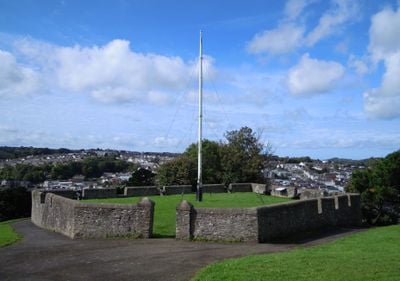
Chudleigh Fort, Military fortification in East-the-Water, Bideford, England

Chudleigh Fort is a five-sided stone structure positioned on high ground with views over the River Torridge, featuring seven cannons arranged along its edges. The fortification stands in the East-the-Water area of Bideford and operates as a public park maintained by Torridge District Council.

The fort began as an earthen gun platform built in 1642 during the English Civil War to defend the river valley. It was later rebuilt in stone during the 1800s, transforming it into the permanent structure visible today.

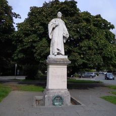
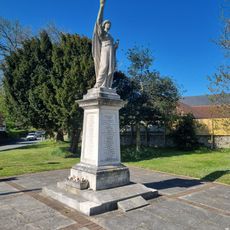
The fort functions as a memorial to local people who died during wartime, and visitors walking through the grounds can sense its role in the community's collective memory. The park setting allows people to reflect on these connections to the past while enjoying the riverside location.

The site is accessible and reached via Chudleigh Avenue in the East-the-Water neighborhood. The hilltop location means the grounds can be breezy and exposed, so it helps to check conditions before visiting.

A historical plaque at the site incorrectly attributes the fort to Major-General Chudleigh, when it was actually built by Sir George Chudleigh. This confusion highlights how commemorative markers can sometimes contain errors that puzzle visitors investigating the true origins of the place.

Location: Bideford

GPS coordinates: 51.01606,-4.19853

Latest update: December 14, 2025 11:41

Photos
Around this place
Bideford Long Bridge
United Kingdom

Bideford Long Bridge

345 m
Moreton House
United Kingdom

Moreton House

2.3 km
Torridge Bridge
United Kingdom

Torridge Bridge

1.5 km
Pannier Market
United Kingdom

Pannier Market

614 m
Church of St Mary
United Kingdom

Church of St Mary

498 m
Burton at Bideford
United Kingdom

Burton at Bideford

743 m
Church of St Margaret
United Kingdom

Church of St Margaret

2.9 km
Bideford Town Hall and Library
United Kingdom

Bideford Town Hall and Library

462 m
The Royal Hotel
United Kingdom

The Royal Hotel

172 m
The Burton at Bideford Art Gallery and Museum
United Kingdom

The Burton at Bideford Art Gallery and Museum

728 m
Bideford Railway Heritage Centre
United Kingdom

Bideford Railway Heritage Centre

176 m
Church of Holy Trinity
United Kingdom

Church of Holy Trinity

2.6 km
Church of St Peter
United Kingdom

Church of St Peter

2.6 km
Lavington United Reformed Church
United Kingdom

Lavington United Reformed Church

699 m
Masonic Hall, Caretaker's House At Rear And Garden Walls At Left And Rear
United Kingdom

Masonic Hall, Caretaker's House At Rear And Garden Walls At Left And Rear

682 m
Kings Arms Public House Including Barn At Rear
United Kingdom

Kings Arms Public House Including Barn At Rear

484 m
Statue of Charles Kingsley
United Kingdom

Statue of Charles Kingsley

636 m
Mill Bridge (That Part On Landcross Cp)
United Kingdom

Mill Bridge (That Part On Landcross Cp)

2.9 km
Bideford War Memorial Cross
United Kingdom

Bideford War Memorial Cross

37 m
Northam War Memorial
United Kingdom

Northam War Memorial

2.6 km
Old Toll
United Kingdom

Old Toll

2.7 km
Milestone Opposite Ship On Launch Public House (Not Included)
United Kingdom

Milestone Opposite Ship On Launch Public House (Not Included)

199 m
Twinaway Bungalow
United Kingdom

Twinaway Bungalow

1.2 km
Bideford And District Angling Club, Attached Walls And Gatepiers
United Kingdom

Bideford And District Angling Club, Attached Walls And Gatepiers

808 m
The Old Custom House
United Kingdom

The Old Custom House

597 m
Milestone Approximately 220 Metres North East Of Entrance To Pillhead House
United Kingdom

Milestone Approximately 220 Metres North East Of Entrance To Pillhead House

1.7 km
Methodist Church Including Schoolrooms And Hall
United Kingdom

Methodist Church Including Schoolrooms And Hall

744 m
Bradavin Farmhouse Including Lofted Outbuilding Adjoining To East
United Kingdom

Bradavin Farmhouse Including Lofted Outbuilding Adjoining To East

2.6 km
Show the full map
Reviews

Visited this place? Tap the stars to rate it and share your experience / photos with the community! Try now! You can cancel it anytime.

« Chudleigh Fort - Military fortification in East-the-Water, Bideford, England » is provided by Around Us (aroundus.com). Images and texts are derived from Wikimedia project under a Creative Commons license. You are allowed to copy, distribute, and modify copies of this page, under the conditions set by the license, as long as this note is clearly visible.

Discover hidden gems everywhere you go!

From secret cafés to breathtaking viewpoints, skip the crowded tourist spots and find places that match your style. Our app makes it easy with voice search, smart filtering, route optimization, and insider tips from travelers worldwide. Download now for the complete mobile experience.

Around Us App Screenshot

A unique approach to discovering new places

Le Figaro

All the places worth exploring

France Info

A tailor-made excursion in just a few clicks

20 Minutes