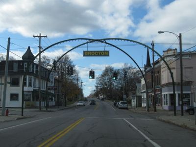
Enable Location

We need your location to show you interesting places around you

Discover nearby places

Find interesting locations and hidden gems around you

Precise directions

Get accurate directions and distances to places

Your location is never shared with other users. It's only used when you tap the location button.

Brocton Arch

Log in to your account

Start exploring — it's free

Trusted by 62,467 travelers worldwide

Continue with Google
Continue with Apple
or

We will send you a code to connect

By continuing, you accept our Terms and Conditions and our Privacy Policy

Check your inbox

We've sent a pincode in your inbox. Please enter the code below.

Brocton Arch

Brocton Arch is a steel gateway structure built in 1913 and located where Main Street intersects with Lake and Highland Avenues. The double-span design was engineered by the Phoenix Bridge Company and Farnham Machine and Foundry Company to serve as a welcoming entrance to the village.

The arch was constructed in 1913 as a welcome symbol celebrating the town's growth and community pride. Between 2012 and 2013, the structure underwent a major cleaning and restoration to preserve its integrity for future visitors and residents.

The arch serves as a community gateway and symbol of local pride for residents, marking where the village begins. Its presence shapes how people experience entering Brocton and connects them to their shared history.

The arch sits at a highly visible intersection on Main Street where multiple roads converge, making it easy to locate when arriving in the village. Access is open and unrestricted, allowing visitors to approach from any direction and stop to view or photograph it at any time.

Brocton Arch is one of the few remaining four-way street arches still standing east of the Mississippi River, making it a rare example. The bright green paint and the village name sign mounted on top were added later, reflecting how the community shaped and personalized the structure over time.

The community of curious travelers

AroundUs brings together thousands of curated places, local tips, and hidden gems, enriched daily by 60,000 contributors worldwide.

Start exploring
Location
GPS coordinates
42.38861,-79.44111
Latest update
February 9, 2026 07:44
Around this place
Palestine Park
United States of America

Palestine Park

20 km
Barcelona Light
United States of America

Barcelona Light

13.7 km
Dunkirk Light
United States of America

Dunkirk Light

13.7 km
Point Chautauqua Historic District
United States of America

Point Chautauqua Historic District

16.9 km
McClurg Museum
United States of America

McClurg Museum

13.4 km
L. Bliss House
United States of America

L. Bliss House

13.9 km
Rorig Bridge
United States of America

Rorig Bridge

13.9 km
Gerald Mack House
United States of America

Gerald Mack House

13.5 km
Frank A. Hall House
United States of America

Frank A. Hall House

13.3 km
Nixon Homestead
United States of America

Nixon Homestead

14.2 km
East Main Street Historic District
United States of America

East Main Street Historic District

12.6 km
Reuben Wright House
United States of America

Reuben Wright House

11.7 km
Henry Dwight Thompson House
United States of America

Henry Dwight Thompson House

13.2 km
Fredonia Commons Historic District
United States of America

Fredonia Commons Historic District

10.7 km
Smith Memorial Library
United States of America

Smith Memorial Library

20.1 km
The Pratt and Buckingham Octagon House
United States of America

The Pratt and Buckingham Octagon House

10.1 km
School No. 7
United States of America

School No. 7

15.7 km
French Portage Road Historic District
United States of America

French Portage Road Historic District

13.5 km
Harriet Campbell-Taylor House
United States of America

Harriet Campbell-Taylor House

13.7 km
Ward House
United States of America

Ward House

14.2 km
Reuben Gridley Wright Farm Complex
United States of America

Reuben Gridley Wright Farm Complex

11.9 km
Atwater-Stone House
United States of America

Atwater-Stone House

13.8 km
Stockton State Forest
United States of America

Stockton State Forest

12.5 km
York-Skinner House
United States of America

York-Skinner House

13.2 km
Fay-Usborne Mill
United States of America

Fay-Usborne Mill

13.1 km
Lewis Miller Cottage
United States of America

Lewis Miller Cottage

20.2 km
Norton Hall
United States of America

Norton Hall

19.9 km
McMahan Homestead
United States of America

McMahan Homestead

15 km
Show the full map
« Brocton Arch » is provided by Around Us (aroundus.com). Images and texts are derived from Wikimedia project under a Creative Commons license. You are allowed to copy, distribute, and modify copies of this page, under the conditions set by the license, as long as this note is clearly visible.

Discover hidden gems everywhere you go!

From secret cafés to breathtaking viewpoints, skip the crowded tourist spots and find places that match your style. Our app makes it easy with voice search, smart filtering, route optimization, and insider tips from travelers worldwide. Download now for the complete mobile experience.

Around Us App Screenshot

A unique approach to discovering new places

Le Figaro

All the places worth exploring

France Info

A tailor-made excursion in just a few clicks

20 Minutes

Around Us
Travel Guide & Maps
Download

Send to your phone

QR Code
1

Open the camera app on your mobile.

2

Point at the QR code with your camera. A notification will appear.

3

Tap the notification to open the link.