Canisteo Living Sign, National Register of Historic Places site in Canisteo, US.
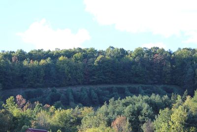
The Canisteo Living Sign is a landscape arrangement of approximately 270 Scotch pine trees planted on a hillside to spell out the town's name. The formation measures roughly 100 yards (91 meters) wide and 300 yards (274 meters) long, creating a visible pattern across the slope.
The sign was created in 1933 during the Depression era and later recognized with a listing in the National Register of Historic Places in 2004. This timeline shows how the creation has remained a lasting feature of the county landscape for many decades.
The name comes from a Seneca word, Kah-ni-sti-oh, which reflects the Native American roots of this region. Today visitors can see how the landscape itself preserves this connection through the planted trees that spell out the town's name.
The clearest views of the sign are available from several locations around town, especially near the Elementary School driveway on Greenwood Street. Early morning hours often provide better visibility since the sun angle helps highlight the tree arrangement.
The tree arrangement was specifically designed to serve as a navigation marker for aircraft, helping pilots orient themselves and confirm true north when flying over the region. This practical aviation function was a deliberate purpose when the sign was created.
The community of curious travelers
AroundUs brings together thousands of curated places, local tips, and hidden gems, enriched daily by 60,000 contributors worldwide.