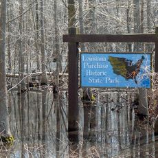
Fifth principal meridian, Principal meridian survey line in eastern Arkansas, US.
The Fifth Principal Meridian is a north-south survey line that begins at the Arkansas River mouth and serves as a foundational reference for land mapping. A granite monument marks the starting point where this line meets the baseline, establishing a crucial coordinate system for surveying multiple states.
This survey line was established in 1815 following the Louisiana Purchase, enabling systematic mapping of newly acquired territory. It became essential for surveying vast areas and establishing land divisions that would guide settlement patterns for generations.
The monument here reflects how early American surveyors systematically mapped and divided the land they were working with. Today visitors can see how these lines shaped property ownership and land use across multiple states.
The site can be reached via a boardwalk that crosses through the swamp to reach the intersection point, offering good access despite the wet terrain. Visitors should prepare for muddy and damp conditions and wear appropriate footwear for walking through swampy ground.
This line still serves as the reference system for property boundaries across multiple states more than two centuries after it was first drawn. Few visitors realize that the boundary line visible today still holds the same legal importance for land measurement that it did when first established.
The community of curious travelers
AroundUs brings together thousands of curated places, local tips, and hidden gems, enriched daily by 60,000 contributors worldwide.