Enable Location

We need your location to show you interesting places around you

Discover nearby places

Find interesting locations and hidden gems around you

Precise directions

Get accurate directions and distances to places

Your location is never shared with other users. It's only used when you tap the location button.

Fishtrap Lake

Log in to your account

Start exploring — it's free

Trusted by 62,527 travelers worldwide

Continue with Google
Continue with Apple
or

We will send you a code to connect

By continuing, you accept our Terms and Conditions and our Privacy Policy

Check your inbox

We've sent a pincode in your inbox. Please enter the code below.

Fishtrap Lake

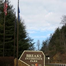
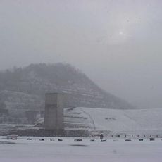
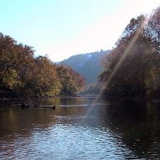
Fishtrap Lake, in the above park

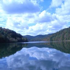
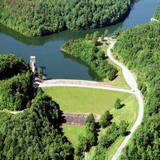
Fishtrap Lake is a reservoir in eastern Kentucky near Pikeville that stretches for more than sixteen miles across a narrow valley. The water is surrounded by dense forests and rocky shores, reaching depths of up to 84 feet in some areas, making it suitable for fishing and boating.

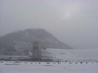
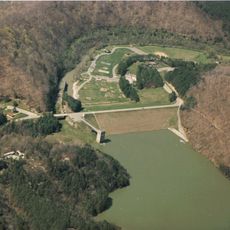
Construction on Fishtrap Dam began in 1962 and was completed in 1968, when President Lyndon Johnson officially opened it. The project was built by the U.S. Army Corps of Engineers to control flooding along the Big Sandy River and prevent damage to surrounding communities.

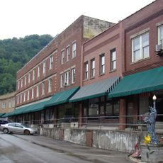
The lake's name comes from ancient fish traps that Native Americans built in this area. The region still carries stories of mountain families and their connection to these lands, making it a place where local history feels close during a visit.

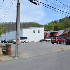
The lake is accessible by taking US 460 south from Pikeville, with different roads leading to the dam and upper sections. Visitors should wear sturdy shoes for walking on uneven terrain, and the steep, forested landscape means you should be prepared for hilly paths and rocky ground.

The dam at nearly 195 feet tall is Kentucky's highest, built by moving millions of cubic yards of earth and rock during construction. Archaeologists have found more than thirty ancient Native American sites near the lake, revealing a long history of occupation in this region before the modern era.

The community of curious travelers

AroundUs brings together thousands of curated places, local tips, and hidden gems, enriched daily by 60,000 contributors worldwide.

Start exploring
Location
GPS coordinates
37.43190,-82.41530
Latest update
February 9, 2026 08:23
Around this place
Breaks Interstate Park
United States of America

Breaks Interstate Park

18.4 km
United States of America

Pikeville Cut-Through

11.9 km
Jenny Wiley State Resort Park
United States of America

Jenny Wiley State Resort Park

40.3 km
Dewey Lake
United States of America

Dewey Lake

43.6 km
Coal House
United States of America

Coal House

29.3 km
Samuel May House
United States of America

Samuel May House

42.5 km
Elkhorn City Railroad Museum
United States of America

Elkhorn City Railroad Museum

15.6 km
Fishtrap Lake State Park
United States of America

Fishtrap Lake State Park

500 m
Ralph Stanley Museum
United States of America

Ralph Stanley Museum

31.6 km
Big Sandy Heritage Center
United States of America

Big Sandy Heritage Center

10.6 km
Sunnydale Farm
United States of America

Sunnydale Farm

33.4 km
Buchanan County Courthouse
United States of America

Buchanan County Courthouse

32.8 km
Martin Himler House
United States of America

Martin Himler House

45.5 km
Clinch Ranger District Cluster
United States of America

Clinch Ranger District Cluster

37.8 km
Methodist Episcopal Church, South
United States of America

Methodist Episcopal Church, South

40.9 km
Dickenson County Courthouse
United States of America

Dickenson County Courthouse

31.6 km
College Street Historic District
United States of America

College Street Historic District

10.6 km
Little Laurel Branch
United States of America

Little Laurel Branch

20.2 km
North Fork of the Pound
United States of America

North Fork of the Pound

39.8 km
Pikeville College Academy Building
United States of America

Pikeville College Academy Building

10.6 km
Williamson Historic District
United States of America

Williamson Historic District

29.8 km
Front Street Historic District
United States of America

Front Street Historic District

41.1 km
Pikeville Commercial Historic District
United States of America

Pikeville Commercial Historic District

10.5 km
Fitzpatrick-Harmon House
United States of America

Fitzpatrick-Harmon House

41.1 km
Matewan Depot Replica Welcome Center and Museum
United States of America

Matewan Depot Replica Welcome Center and Museum

30.4 km
North Fork Pound Reservoir
United States of America

North Fork Pound Reservoir

39.2 km
Matewan Historic District
United States of America

Matewan Historic District

30.6 km
Boldman Bridge
United States of America

Boldman Bridge

21.1 km
Show the full map
« Fishtrap Lake - in the above park » is provided by Around Us (aroundus.com). Images and texts are derived from Wikimedia project under a Creative Commons license. You are allowed to copy, distribute, and modify copies of this page, under the conditions set by the license, as long as this note is clearly visible.

Discover hidden gems everywhere you go!

From secret cafés to breathtaking viewpoints, skip the crowded tourist spots and find places that match your style. Our app makes it easy with voice search, smart filtering, route optimization, and insider tips from travelers worldwide. Download now for the complete mobile experience.

Around Us App Screenshot

A unique approach to discovering new places

Le Figaro

All the places worth exploring

France Info

A tailor-made excursion in just a few clicks

20 Minutes

Around Us
Travel Guide & Maps
Download

Send to your phone

QR Code
1

Open the camera app on your mobile.

2

Point at the QR code with your camera. A notification will appear.

3

Tap the notification to open the link.