Log in to your account

AroundUs is a community-driven map of interesting places, built by curious explorers like you. It grows with every review, story, and photo you share.
Connect to save your favorite spots, contribute locations, and create personalized routes.
Continue with Google
Continue with Apple
Continue with X
Continue with Facebook
Continue with email
By continuing, you accept our Terms and Conditions and our Privacy Policy
Create an account

Fort Prince George

Add to collection
Map
Suggest a change
Share

Fort Prince George, Colonial fort in Pickens County, South Carolina.

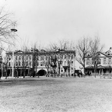
Fort Prince George was a fortified trading post built in 1753 with earthen and wooden walls arranged in a square shape and defended by a surrounding trench. The installation housed soldiers and merchants who managed commerce and military operations from this strategic location.

The fort was established in 1753 directly across from the Cherokee settlement of Keowee and operated as a major trading post for lower Cherokee towns until 1768. Its construction marked a shift in colonial presence and influence in the region.

The place served as a meeting point where British soldiers and Cherokee people conducted business and built relationships that shaped daily life. Both communities relied on the exchange of goods and information that happened at this location.

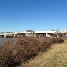
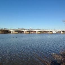
The site is now submerged beneath Lake Keowee, but visitors can learn about the location through nearby overlooks and regional museums that display findings from archaeological work. Historical interpretation centers provide context about the people who lived and worked there during the colonial period.

Extensive archaeological digs in the 1970s uncovered everyday objects like musket balls, cannonballs, rum bottles, and cooking tools that had been abandoned at the site. These discoveries offer rare glimpses into how people actually lived and what they used at this remote frontier location.

GPS coordinates: 38.88100,-76.98746

Latest update: December 10, 2025 20:04

Photos
Around this place
Washington Navy Yard
United States of America

Washington Navy Yard

1 km
Emancipation Memorial
United States of America

Emancipation Memorial

1 km
Congressional Cemetery
United States of America

Congressional Cemetery

887 m
National Museum of the United States Navy
United States of America

National Museum of the United States Navy

1.1 km
Eastern Market
United States of America

Eastern Market

998 m
Tingey House
United States of America

Tingey House

823 m
D.C. Jail
United States of America

D.C. Jail

1 km
Mary McLeod Bethune Memorial
United States of America

Mary McLeod Bethune Memorial

979 m
11th Street Bridges
United States of America

11th Street Bridges

1 km
Lincoln Park
United States of America

Lincoln Park

988 m
Officers Quarters, Washington Navy Yard
United States of America

Officers Quarters, Washington Navy Yard

831 m
Latrobe Gate
United States of America

Latrobe Gate

850 m
Marine Corps Museum
United States of America

Marine Corps Museum

784 m
United States of America

Barracks Row

654 m
East Capitol Street Car Barn
United States of America

East Capitol Street Car Barn

1 km
Public Vault at the Congressional Cemetery
United States of America

Public Vault at the Congressional Cemetery

770 m
Holy Comforter-St. Cyprian Catholic Church
United States of America

Holy Comforter-St. Cyprian Catholic Church

957 m
Washington and Georgetown Railroad Car House
United States of America

Washington and Georgetown Railroad Car House

763 m
Friendship House
United States of America

Friendship House

973 m
Olive Risley Seward
United States of America

Olive Risley Seward

1.1 km
Alexander Dallas Bache Monument
United States of America

Alexander Dallas Bache Monument

835 m
Saint Paul African Union Methodist Church
United States of America

Saint Paul African Union Methodist Church

1.2 km
Commandant's Office, Washington Navy Yard
United States of America

Commandant's Office, Washington Navy Yard

1.1 km
Pennsylvania Avenue Bridge
United States of America

Pennsylvania Avenue Bridge

932 m
Southeast Neighborhood Library
United States of America

Southeast Neighborhood Library

846 m
Marion Park
United States of America

Marion Park

1.1 km
John Philip Sousa Bridge
United States of America

John Philip Sousa Bridge

946 m
Latrobe cenotaphs
United States of America

Latrobe cenotaphs

830 m
Show the full map
Reviews

Visited this place? Tap the stars to rate it and share your experience / photos with the community! Try now! You can cancel it anytime.

« Fort Prince George - Colonial fort in Pickens County, South Carolina » is provided by Around Us (aroundus.com). Images and texts are derived from Wikimedia project under a Creative Commons license. You are allowed to copy, distribute, and modify copies of this page, under the conditions set by the license, as long as this note is clearly visible.

Discover hidden gems everywhere you go!

From secret cafés to breathtaking viewpoints, skip the crowded tourist spots and find places that match your style. Our app makes it easy with voice search, smart filtering, route optimization, and insider tips from travelers worldwide. Download now for the complete mobile experience.

Around Us App Screenshot

A unique approach to discovering new places

Le Figaro

All the places worth exploring

France Info

A tailor-made excursion in just a few clicks

20 Minutes