Enable Location

We need your location to show you interesting places around you

Discover nearby places

Find interesting locations and hidden gems around you

Precise directions

Get accurate directions and distances to places

Your location is never shared with other users. It's only used when you tap the location button.

Gambrill State Park

Log in to your account

Start exploring — it's free

Trusted by 62,586 travelers worldwide

Continue with Google
Continue with Apple
or

We will send you a code to connect

By continuing, you accept our Terms and Conditions and our Privacy Policy

Check your inbox

We've sent a pincode in your inbox. Please enter the code below.

Gambrill State Park

Gambrill State Park, State park in Frederick County, Maryland, US

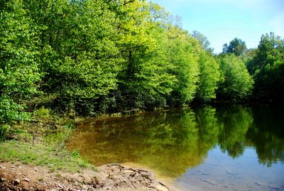
Gambrill State Park is a forested mountain area covering more than 1,200 acres with elevations climbing to around 1,800 feet. A network of over 16 miles of trails connects different parts of the park for various recreational activities throughout the seasons.

The park was established in 1934 when Frederick transferred the land to Maryland and named it after James H. Gambrill Jr., a local conservation advocate. Workers from the Civilian Conservation Corps built stone structures and recreational facilities during the 1930s that remain visible throughout the property today.

The Civilian Conservation Corps workers constructed stone shelters and recreational facilities during the Great Depression, leaving a lasting architectural legacy.

The park provides 31 family campsites and four wooden cabins throughout its grounds, along with visitor facilities and picnic areas. The property is open year-round, though weather conditions at higher elevations can change quickly, so visitors should be prepared for variable conditions.

High Knob and Rock Run are elevated spots where visitors can look out over the surrounding Catoctin Mountains. These locations serve as habitats for black bears and other forest creatures that occasionally cross paths with park visitors.

The community of curious travelers

AroundUs brings together thousands of curated places, local tips, and hidden gems, enriched daily by 60,000 contributors worldwide.

Start exploring
Location
Inception
1934
GPS coordinates
39.47330,-77.49190
Latest update
December 9, 2025 18:47
Around this place
Hood College
United States of America

Hood College

8.5 km
Building 470
United States of America

Building 470

6.8 km
One-Million-Liter Test Sphere
United States of America

One-Million-Liter Test Sphere

6.9 km
Rose Hill Manor
United States of America

Rose Hill Manor

8.5 km
Schifferstadt
United States of America

Schifferstadt

7.9 km
Frederick Historic District
United States of America

Frederick Historic District

9.5 km
Way Off Broadway Dinner Theatre
United States of America

Way Off Broadway Dinner Theatre

6.9 km
Spring Bank Farm
United States of America

Spring Bank Farm

8.4 km
Nallin Farm House
United States of America

Nallin Farm House

7.3 km
Nallin Farm Springhouse and Bank Barn
United States of America

Nallin Farm Springhouse and Bank Barn

7.2 km
Beth Sholom Congregation
United States of America

Beth Sholom Congregation

8.9 km
Monocacy River bridge and viaduct
United States of America

Monocacy River bridge and viaduct

8.6 km
Middletown Historic District
United States of America

Middletown Historic District

5.5 km
Frederick Armory
United States of America

Frederick Armory

9.2 km
Airview Historic District
United States of America

Airview Historic District

4.9 km
Highland Lodge
United States of America

Highland Lodge

6.1 km
Henry Shoemaker Farmhouse
United States of America

Henry Shoemaker Farmhouse

8.9 km
Bowlus Mill House
United States of America

Bowlus Mill House

6.1 km
Edgewood
United States of America

Edgewood

6 km
Shafer's Mill
United States of America

Shafer's Mill

9.4 km
Routzahn-Miller Farmstead
United States of America

Routzahn-Miller Farmstead

8.6 km
Rich Mountain
United States of America

Rich Mountain

7 km
John C. Motter House
United States of America

John C. Motter House

8.7 km
Tuscarora Creek (Monocacy River) bridge
United States of America

Tuscarora Creek (Monocacy River) bridge

8.5 km
Stonebraker and Harbaugh–Shafer Building
United States of America

Stonebraker and Harbaugh–Shafer Building

5.8 km
Schifferstadt Architectural Museum
United States of America

Schifferstadt Architectural Museum

7.9 km
Kol Ami of Frederick
United States of America

Kol Ami of Frederick

9.4 km
James K.P. Wolfe House
United States of America

James K.P. Wolfe House

8.5 km
Show the full map
« Gambrill State Park - State park in Frederick County, Maryland, US » is provided by Around Us (aroundus.com). Images and texts are derived from Wikimedia project under a Creative Commons license. You are allowed to copy, distribute, and modify copies of this page, under the conditions set by the license, as long as this note is clearly visible.

Discover hidden gems everywhere you go!

From secret cafés to breathtaking viewpoints, skip the crowded tourist spots and find places that match your style. Our app makes it easy with voice search, smart filtering, route optimization, and insider tips from travelers worldwide. Download now for the complete mobile experience.

Around Us App Screenshot

A unique approach to discovering new places

Le Figaro

All the places worth exploring

France Info

A tailor-made excursion in just a few clicks

20 Minutes

Around Us
Travel Guide & Maps
Download

Send to your phone

QR Code
1

Open the camera app on your mobile.

2

Point at the QR code with your camera. A notification will appear.

3

Tap the notification to open the link.