Enable Location

We need your location to show you interesting places around you

Discover nearby places

Find interesting locations and hidden gems around you

Precise directions

Get accurate directions and distances to places

Your location is never shared with other users. It's only used when you tap the location button.

Geode State Park

Log in to your account

Start exploring — it's free

Trusted by 62,472 travelers worldwide

Continue with Google
Continue with Apple
or

We will send you a code to connect

By continuing, you accept our Terms and Conditions and our Privacy Policy

Check your inbox

We've sent a pincode in your inbox. Please enter the code below.

Geode State Park, State park and historic site in southeastern Iowa, United States.

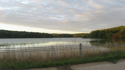
Geode State Park is a scenic area in southeastern Iowa centered around a large lake surrounded by wooded ridges and limestone cliffs. The lake covers roughly 187 acres within the park's 1,640-acre boundaries, creating a natural focal point for outdoor recreation.

The Civilian Conservation Corps built the park's core infrastructure starting in 1937, including roads, shelters, and facilities that serve visitors to this day. The work programs of that era shaped the layout and accessibility of the site.

The region was home to Native American peoples whose artifacts remain scattered across the land near the Skunk River. This heritage shapes how visitors understand the park's deeper connection to the landscape.

Two boat ramps provide access on the lake's east side, with speed limits enforced to protect the shoreline from damage. Plan your visit during daylight hours and check conditions before bringing watercraft to ensure a smooth experience.

The park office displays geode specimens that give the site its name, but visitors are not allowed to collect these rock formations within the boundaries. This restriction helps preserve the natural landscape for everyone to enjoy.

The community of curious travelers

AroundUs brings together thousands of curated places, local tips, and hidden gems, enriched daily by 60,000 contributors worldwide.

Start exploring
Location
Inception
1937
Architects
Central Design Office, Ames
Elevation above the sea
204 m
GPS coordinates
40.82610,-91.38030
Latest update
December 10, 2025 20:02
Around this place
Community Field
United States of America

Community Field

20.5 km
United States of America

Old Thresher's Reunion

20.1 km
Union Block
United States of America

Union Block

21.3 km
Harlan-Lincoln House
United States of America

Harlan-Lincoln House

21.6 km
Bridgeport Bridge
United States of America

Bridgeport Bridge

4.2 km
Masonic Temple Theater
United States of America

Masonic Temple Theater

21.4 km
Midwest Old Threshers Heritage Museums & Business Office
United States of America

Midwest Old Threshers Heritage Museums & Business Office

20.1 km
Henderson Lewelling House
United States of America

Henderson Lewelling House

20.5 km
Farmers Savings Bank
United States of America

Farmers Savings Bank

20.6 km
John and Lavina Bangs House
United States of America

John and Lavina Bangs House

9.8 km
Daniel McConn Barn
United States of America

Daniel McConn Barn

21.2 km
Henry County Courthouse
United States of America

Henry County Courthouse

21.2 km
Old Main
United States of America

Old Main

21.5 km
Holtkamp Round Barn
United States of America

Holtkamp Round Barn

15.9 km
Owen A. and Emma J. Garretson House
United States of America

Owen A. and Emma J. Garretson House

16.7 km
Former Mount Pleasant Public Library
United States of America

Former Mount Pleasant Public Library

21.4 km
Baptist Church
United States of America

Baptist Church

21.2 km
Smith and Weller Building
United States of America

Smith and Weller Building

11.4 km
Dennis Melcher Pottery and House
United States of America

Dennis Melcher Pottery and House

1.3 km
Joseph A. and Lydia A. Edwards House
United States of America

Joseph A. and Lydia A. Edwards House

16.7 km
G. W. S. Allen House
United States of America

G. W. S. Allen House

21.4 km
Isaac and Agnes
United States of America

Isaac and Agnes

20.5 km
Mount Pleasant City Hall
United States of America

Mount Pleasant City Hall

21.5 km
Collins-Bond House
United States of America

Collins-Bond House

20.5 km
Lamm-Pollmiller Farmstead District
United States of America

Lamm-Pollmiller Farmstead District

19 km
Henry County Savings Bank
United States of America

Henry County Savings Bank

21.3 km
Bicksler Block
United States of America

Bicksler Block

20.6 km
Cook-Johnson House
United States of America

Cook-Johnson House

20.7 km
Show the full map
« Geode State Park - State park and historic site in southeastern Iowa, United States » is provided by Around Us (aroundus.com). Images and texts are derived from Wikimedia project under a Creative Commons license. You are allowed to copy, distribute, and modify copies of this page, under the conditions set by the license, as long as this note is clearly visible.

Discover hidden gems everywhere you go!

From secret cafés to breathtaking viewpoints, skip the crowded tourist spots and find places that match your style. Our app makes it easy with voice search, smart filtering, route optimization, and insider tips from travelers worldwide. Download now for the complete mobile experience.

Around Us App Screenshot

A unique approach to discovering new places

Le Figaro

All the places worth exploring

France Info

A tailor-made excursion in just a few clicks

20 Minutes

Around Us
Travel Guide & Maps
Download

Send to your phone

QR Code
1

Open the camera app on your mobile.

2

Point at the QR code with your camera. A notification will appear.

3

Tap the notification to open the link.