Enable Location

We need your location to show you interesting places around you

Discover nearby places

Find interesting locations and hidden gems around you

Precise directions

Get accurate directions and distances to places

Your location is never shared with other users. It's only used when you tap the location button.

Governor Thomas Johnson Bridge

Log in to your account

Start exploring — it's free

Trusted by 63,123 travelers worldwide

Continue with Google
Continue with Apple
or

We will send you a code to connect

By continuing, you accept our Terms and Conditions and our Privacy Policy

Check your inbox

We've sent a pincode in your inbox. Please enter the code below.

Governor Thomas Johnson Bridge
Discussion Reviews 1 Photos
10.9k Popularity

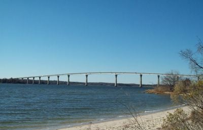
Governor Thomas Johnson Bridge, Road bridge across Patuxent River in Maryland, US

The Governor Thomas Johnson Bridge crosses the Patuxent River between St. Mary's County and Calvert County, standing 43 meters high. It uses both arch and beam design to handle traffic on the road and allow boats to pass underneath.

The bridge opened in December 1977 and connected two counties that had been separated before. This opening made traveling through southern Maryland easier for people living and working in the area.

The bridge includes separate paths for cyclists, showing how the region values different ways to travel beyond cars. This design choice reflects a practical attitude toward moving people through the landscape.

The bridge accommodates cars, trucks, and bicycles with separate paths for each. It is useful to check traffic conditions before crossing, particularly during rush hours or after heavy rain.

The structure combines arch and beam techniques in a way that lets it carry traffic while allowing sailing boats to pass underneath. This dual approach solved a common challenge when building bridges over navigable rivers.

The community of curious travelers

AroundUs brings together thousands of curated places, local tips, and hidden gems, enriched daily by 60,000 contributors worldwide.

Start exploring
Location
Location
Official opening
1977
Height
43 m
GPS coordinates
38.32631,-76.47145
Latest update
December 8, 2025 13:44
Reviews
Share your experience

No review yet

Discussions
Start a discussion...

No discussion yet

« Governor Thomas Johnson Bridge - Road bridge across Patuxent River in Maryland, US » is provided by Around Us (aroundus.com). Images and texts are derived from Wikimedia project under a Creative Commons license. You are allowed to copy, distribute, and modify copies of this page, under the conditions set by the license, as long as this note is clearly visible.

Discover hidden gems everywhere you go!

From secret cafés to breathtaking viewpoints, skip the crowded tourist spots and find places that match your style. Our app makes it easy with voice search, smart filtering, route optimization, and insider tips from travelers worldwide. Download now for the complete mobile experience.

Around Us App Screenshot

A unique approach to discovering new places

Le Figaro

All the places worth exploring

France Info

A tailor-made excursion in just a few clicks

20 Minutes

Around Us
Travel Guide & Maps
Download

Send to your phone

QR Code
1

Open the camera app on your mobile.

2

Point at the QR code with your camera. A notification will appear.

3

Tap the notification to open the link.