Enable Location

We need your location to show you interesting places around you

Discover nearby places

Find interesting locations and hidden gems around you

Precise directions

Get accurate directions and distances to places

Your location is never shared with other users. It's only used when you tap the location button.

Harlan County Reservoir

Log in to your account

Start exploring — it's free

Trusted by 62,281 travelers worldwide

Continue with Google
Continue with Apple
or

We will send you a code to connect

By continuing, you accept our Terms and Conditions and our Privacy Policy

Check your inbox

We've sent a pincode in your inbox. Please enter the code below.

Harlan County Reservoir

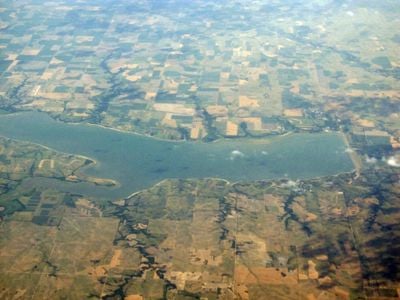
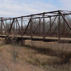
Harlan County Reservoir, body of water

Harlan County Reservoir is a large lake in south-central Nebraska that spans about 13,000 acres. The water has gentle shorelines with trees and rocky points, while the basin contains both shallow zones along the edges and deeper sections where fish gather around structures.

The reservoir was created by damming the river to control water flow and supply water to nearby communities. Since its completion, it has become a popular destination for recreation and fishing while helping to manage floods in the region.

The reservoir takes its name from Harlan County, where it is located. You can observe how local anglers and families use the water throughout the day, with fishing boats heading out at sunrise and people gathering along the shores in the evening.

The reservoir has public boat ramps and marinas where you can rent boats or launch your own. Nearby you will find campsites, RV parks, and shops for bait and fishing equipment, making it easy to spend a day or weekend here.

In winter the surface freezes and permits ice fishing for walleye, with anglers using GPS to find their best spots. This season requires special techniques like slow pulls with jerkbaits to attract fish that are less aggressive in cold water.

The community of curious travelers

AroundUs brings together thousands of curated places, local tips, and hidden gems, enriched daily by 60,000 contributors worldwide.

Start exploring
Location
GPS coordinates
40.06306,-99.29056
Latest update
February 7, 2026 11:01
Around this place
Pioneer Village
United States of America

Pioneer Village

57 km
Home on the Range Cabin
United States of America

Home on the Range Cabin

35.1 km
William Ducker House
United States of America

William Ducker House

65.1 km
Prairie Dog Creek Bridge
United States of America

Prairie Dog Creek Bridge

17.4 km
Franklin Bridge
United States of America

Franklin Bridge

28.9 km
Salem Swedish Methodist Episcopal Church
United States of America

Salem Swedish Methodist Episcopal Church

44.4 km
First Congregational Church, U.C.C.
United States of America

First Congregational Church, U.C.C.

12.8 km
Pleasant Ridge Church
United States of America

Pleasant Ridge Church

8.9 km
Kearney County Courthouse
United States of America

Kearney County Courthouse

56.6 km
Kinner House
United States of America

Kinner House

42.6 km
Norton Downtown Historic District
United States of America

Norton Downtown Historic District

57.3 km
United States of America

Minden United States Post Office

56.6 km
First National Bank Building
United States of America

First National Bank Building

53.5 km
Alma City Auditorium and Sale Barn
United States of America

Alma City Auditorium and Sale Barn

7.3 km
Franklin County Courthouse
United States of America

Franklin County Courthouse

28.9 km
Phelps County Courthouse
United States of America

Phelps County Courthouse

42.4 km
W. T. Thorne Building
United States of America

W. T. Thorne Building

56.6 km
North Fork Solomon River Lattice Truss Bridge
United States of America

North Fork Solomon River Lattice Truss Bridge

57 km
Miner House
United States of America

Miner House

65.5 km
United States of America

William Cather Homestead Site

56.5 km
Warner-Cather House
United States of America

Warner-Cather House

65.5 km
Hoff School District No. 42
United States of America

Hoff School District No. 42

42.7 km
Kirwin City Hall
United States of America

Kirwin City Hall

45.7 km
Pottawatomie County Fair Pavilion
United States of America

Pottawatomie County Fair Pavilion

60.2 km
Dr. Gilbert McKeeby House
United States of America

Dr. Gilbert McKeeby House

65.2 km
Kirwin National Wildlife Refuge
United States of America

Kirwin National Wildlife Refuge

47.8 km
Farmer's Bridge
United States of America

Farmer's Bridge

46.6 km
Turkey Creek Bridge
United States of America

Turkey Creek Bridge

25.8 km
Show the full map
« Harlan County Reservoir - body of water » is provided by Around Us (aroundus.com). Images and texts are derived from Wikimedia project under a Creative Commons license. You are allowed to copy, distribute, and modify copies of this page, under the conditions set by the license, as long as this note is clearly visible.

Discover hidden gems everywhere you go!

From secret cafés to breathtaking viewpoints, skip the crowded tourist spots and find places that match your style. Our app makes it easy with voice search, smart filtering, route optimization, and insider tips from travelers worldwide. Download now for the complete mobile experience.

Around Us App Screenshot

A unique approach to discovering new places

Le Figaro

All the places worth exploring

France Info

A tailor-made excursion in just a few clicks

20 Minutes

Around Us
Travel Guide & Maps
Download

Send to your phone

QR Code
1

Open the camera app on your mobile.

2

Point at the QR code with your camera. A notification will appear.

3

Tap the notification to open the link.