Enable Location

We need your location to show you interesting places around you

Discover nearby places

Find interesting locations and hidden gems around you

Precise directions

Get accurate directions and distances to places

Your location is never shared with other users. It's only used when you tap the location button.

Huntley Meadows Park

Log in to your account

Start exploring — it's free

Trusted by 61,564 travelers worldwide

Continue with Google
Continue with Apple
or

We will send you a code to connect

By continuing, you accept our Terms and Conditions and our Privacy Policy

Check your inbox

We've sent a pincode in your inbox. Please enter the code below.

Huntley Meadows Park

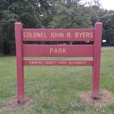
Huntley Meadows Park, Nature reserve in Alexandria, Virginia.

Description

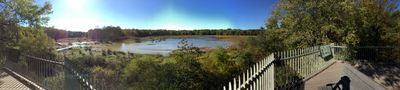
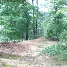
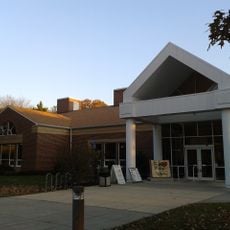
Huntley Meadows Park is a nature reserve featuring wetlands, forests, and meadows situated in a natural depression that filters suburban stormwater through diverse ecosystems. The landscape includes a central marsh accessible by boardwalk and observation platforms, with additional forested trails winding through the surrounding area.

History

The land was originally part of an 18th-century estate and underwent extensive drainage modifications before cultivation could occur. Beaver activity later reshaped the waterways by creating dams, transforming the cleared areas back into the open wetlands visible today.

Culture

The park serves as a gathering place for birdwatchers and nature observers who come to spot migrating species and resident wildlife throughout the year. Local volunteer groups actively monitor and document the plant and animal populations that thrive here.

Practical

The park features a half-mile boardwalk with observation platforms that leads through the central marsh, and additional trails wind through forested sections. Early morning and late afternoon visits offer the best chances for spotting wildlife, as most animals are most active during these quieter hours.

Did you know?

Beavers shaped the current landscape by damming streams and creating open wetlands that now support diverse wildlife including barred owls and prothonotary warblers. This natural reclamation reveals how wildlife can transform abandoned or altered land back into thriving habitat.

Location
Location
Inception
1975
Operator
Fairfax County Park Authority
GPS coordinates
38.76020,-77.09560
Latest update
December 8, 2025 19:57

AroundUs brings together thousands of curated places, local tips, and hidden gems, enriched daily by 60,000 contributors worldwide. Discover all places nearby (Fairfax).

Around this place
Mount Vernon
United States of America

Mount Vernon

5.9 km
George Washington's Mount Vernon
United States of America

George Washington's Mount Vernon

5.9 km
Mount Vernon Trail
United States of America

Mount Vernon Trail

6.3 km
Fred W. Smith National Library for the Study of George Washington
United States of America

Fred W. Smith National Library for the Study of George Washington

5.3 km
Woodlawn
United States of America

Woodlawn

6 km
George Washington's Gristmill
United States of America

George Washington's Gristmill

6.1 km
Pope-Leighey House
United States of America

Pope-Leighey House

5.7 km
River Farm
United States of America

River Farm

4.8 km
Fort Hunt
United States of America

Fort Hunt

6.3 km
Fort Lyon
United States of America

Fort Lyon

4.1 km
Huntley
United States of America

Huntley

606 m
Cameron Run Regional Park
United States of America

Cameron Run Regional Park

5 km
Fort Willard
United States of America

Fort Willard

3.6 km
Fort O'Rourke
United States of America

Fort O'Rourke

3.6 km
National Museum of the United States Army
United States of America

National Museum of the United States Army

7.7 km
Fort Farnsworth
United States of America

Fort Farnsworth

4.2 km
Tower House
United States of America

Tower House

6 km
Tauxemont Historic District
United States of America

Tauxemont Historic District

4.1 km
Tower House
United States of America

Tower House

6 km
Woodlawn Quaker Meetinghouse
United States of America

Woodlawn Quaker Meetinghouse

6.5 km
St. Mark's Episcopal Church
United States of America

St. Mark's Episcopal Church

1.4 km
George Washington's Distillery & Gristmill
United States of America

George Washington's Distillery & Gristmill

6 km
Colonel John R. Byers Park
United States of America

Colonel John R. Byers Park

3.5 km
Regal Springfield Town Center Stadium 12
United States of America

Regal Springfield Town Center Stadium 12

7.5 km
Martha Washington Community Library
United States of America

Martha Washington Community Library

3.2 km
Charles E. Beatley, Jr. Central Library
United States of America

Charles E. Beatley, Jr. Central Library

6.1 km
Sherwood Regional Library
United States of America

Sherwood Regional Library

2.5 km
Kingstowne Community Library
United States of America

Kingstowne Community Library

6.4 km
Show the full map
« Huntley Meadows Park - Nature reserve in Alexandria, Virginia » is provided by Around Us (aroundus.com). Images and texts are derived from Wikimedia project under a Creative Commons license. You are allowed to copy, distribute, and modify copies of this page, under the conditions set by the license, as long as this note is clearly visible.

Discover hidden gems everywhere you go!

From secret cafés to breathtaking viewpoints, skip the crowded tourist spots and find places that match your style. Our app makes it easy with voice search, smart filtering, route optimization, and insider tips from travelers worldwide. Download now for the complete mobile experience.

Around Us App Screenshot

A unique approach to discovering new places

Le Figaro

All the places worth exploring

France Info

A tailor-made excursion in just a few clicks

20 Minutes

Around Us
Travel Guide & Maps
Download

Send to your phone

QR Code
1

Open the camera app on your mobile.

2

Point at the QR code with your camera. A notification will appear.

3

Tap the notification to open the link.