Enable Location

We need your location to show you interesting places around you

Discover nearby places

Find interesting locations and hidden gems around you

Precise directions

Get accurate directions and distances to places

Your location is never shared with other users. It's only used when you tap the location button.

Kuykendall Polygonal Barn

Log in to your account

Join the adventure

Create your free account and start exploring (like 60k+ others)

We will send you a code to connect

or
Continue with Google
Continue with Apple
By continuing, you accept our Terms and Conditions and our Privacy Policy

Check your inbox

We've sent a pincode in your inbox. Please enter the code below.

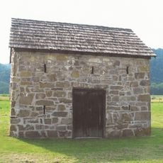
Kuykendall Polygonal Barn, Historic polygonal barn in Romney, West Virginia, United States

Description

The Kuykendall Polygonal Barn is a fifteen-sided structure located near Romney, positioned in the South Branch Potomac River valley. The building features multiple large doors arranged around its perimeter to allow easy access for livestock management and farm storage.

History

John Clowser oversaw the construction of this barn in 1906 on a farm whose land was originally granted by Thomas Fairfax to the Van Meter family in 1749. The building represents the adoption of advanced agricultural methods during the early twentieth century.

Culture

The barn represents a local landmark that demonstrates how farmers adapted building design to improve their work and storage practices. Its distinctive shape reflects the practical thinking that shaped rural communities in this valley.

Practical

The barn sits along South Branch River Road in Romney, making it accessible from this main rural road through the area. The setting provides views of the surrounding river landscape and farmland.

Did you know?

This building stands as the only documented fifteen-sided barn ever built in West Virginia, making it exceptionally rare among American agricultural structures. Its unusual polygon shape was an experimental approach to maximize space and work efficiency for farmers.

Location
GPS coordinates
39.23530,-78.84330
Latest update
December 14, 2025 18:45

AroundUs brings together thousands of curated places, local tips, and hidden gems, enriched daily by 60,000 contributors worldwide. Discover all places nearby (West Virginia).

Around this place
Literary Hall
United States of America

Literary Hall

14.1 km
Sloan–Parker House
United States of America

Sloan–Parker House

8.7 km
Valley View
United States of America

Valley View

15.2 km
Indian Mound Cemetery
United States of America

Indian Mound Cemetery

13.7 km
Washington Bottom Farm
United States of America

Washington Bottom Farm

21.8 km
Confederate Memorial
United States of America

Confederate Memorial

13.7 km
Fort Mill Ridge Civil War Trenches
United States of America

Fort Mill Ridge Civil War Trenches

10.8 km
Fort Pleasant
United States of America

Fort Pleasant

14.5 km
United States of America

Piss Pot Island

12.3 km
Fort Van Meter
United States of America

Fort Van Meter

167 m
Wilson-Wodrow-Mytinger House
United States of America

Wilson-Wodrow-Mytinger House

13.9 km
Hampshire County Courthouse
United States of America

Hampshire County Courthouse

14.1 km
Clifford Hollow Bridge
United States of America

Clifford Hollow Bridge

16 km
Taggart Hall
United States of America

Taggart Hall

13.9 km
Washington Place
United States of America

Washington Place

15.4 km
Garrett VanMeter House
United States of America

Garrett VanMeter House

13.6 km
French's Mill
United States of America

French's Mill

19 km
Weaver's Antique Service Station
United States of America

Weaver's Antique Service Station

13.1 km
Travelers Rest
United States of America

Travelers Rest

16.4 km
Nathaniel and Isaac Kuykendall House
United States of America

Nathaniel and Isaac Kuykendall House

7.5 km
Buena Vista Farms
United States of America

Buena Vista Farms

15 km
Hickory Grove
United States of America

Hickory Grove

11.3 km
P.W. Inskeep House
United States of America

P.W. Inskeep House

20.8 km
Carskadon House
United States of America

Carskadon House

17.2 km
Burlington Historic District
United States of America

Burlington Historic District

13 km
McCoy's Grand Theatre
United States of America

McCoy's Grand Theatre

22.1 km
Old Methodist District Parsonage
United States of America

Old Methodist District Parsonage

14.4 km
169 East Main Street (Romney, West Virginia)
United States of America

169 East Main Street (Romney, West Virginia)

14.1 km
Show the full map
« Kuykendall Polygonal Barn - Historic polygonal barn in Romney, West Virginia, United States » is provided by Around Us (aroundus.com). Images and texts are derived from Wikimedia project under a Creative Commons license. You are allowed to copy, distribute, and modify copies of this page, under the conditions set by the license, as long as this note is clearly visible.

Discover hidden gems everywhere you go!

From secret cafés to breathtaking viewpoints, skip the crowded tourist spots and find places that match your style. Our app makes it easy with voice search, smart filtering, route optimization, and insider tips from travelers worldwide. Download now for the complete mobile experience.

Around Us App Screenshot

A unique approach to discovering new places

Le Figaro

All the places worth exploring

France Info

A tailor-made excursion in just a few clicks

20 Minutes

Around Us
Travel Guide & Maps
Download

Send to your phone

QR Code
1

Open the camera app on your mobile.

2

Point at the QR code with your camera. A notification will appear.

3

Tap the notification to open the link.